Difference between revisions of "Guidance for categorical TMDLs"
| Line 4: | Line 4: | ||
<ol> | <ol> | ||
| + | |||
<li> '''Area approach.''' The WLA can be divided based on the relative area of each MS4. Only the areas within the study watershed should be considered. For example, if two MS4s have a WLA of 100 lbs/day, MS4 A covers 75% of the study area and MS4 B covers 25% of the study area, the target loads would be 75 lbs/day for MS4 A and 25 lbs/day for MS4 B. This is a desirable approach if the pollutant loading per unit area is considered similar across all MS4s. | <li> '''Area approach.''' The WLA can be divided based on the relative area of each MS4. Only the areas within the study watershed should be considered. For example, if two MS4s have a WLA of 100 lbs/day, MS4 A covers 75% of the study area and MS4 B covers 25% of the study area, the target loads would be 75 lbs/day for MS4 A and 25 lbs/day for MS4 B. This is a desirable approach if the pollutant loading per unit area is considered similar across all MS4s. | ||
Revision as of 13:28, 21 October 2019
This is an alert message!
It is not necessary or required for an MS4 to derive an individual waste load allocation (WLA) for a total maximum daily load (TMDL) that developed categorical MS4 (Municipal Separate Storm Sewer System) wasteload allocations (WLAs). However, if you do want to determine your MS4’s portion of the categorical WLA, the following approaches can be used:
- Area approach. The WLA can be divided based on the relative area of each MS4. Only the areas within the study watershed should be considered. For example, if two MS4s have a WLA of 100 lbs/day, MS4 A covers 75% of the study area and MS4 B covers 25% of the study area, the target loads would be 75 lbs/day for MS4 A and 25 lbs/day for MS4 B. This is a desirable approach if the pollutant loading per unit area is considered similar across all MS4s.
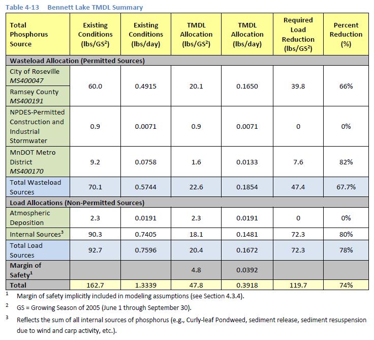
The TMDL report may contain information that is useful for this approach. For example, the Ramsey Washington Metro Watershed District Watershed TMDL report (2017) contains the following table. This information, along with the TMDL table can be used to derive an individual WLA.
MS4 Summary for Bennett Lake
Link to this tableWaterbody MS4 Name MS4 ID Number MS4 Area within the contributing watershed (acres) Bennett Lake City of Roseville MS400047 632 Ramsey County MS400191 45 MnDOT Metro District MS400170 55 The TMDL table below shows that the total WLA minus the WLA for construction and industrial stormwater is 21.7 lbs/yr. According to the table above, Roseville is 86% of the total MS4 area and Ramsey County is 6%, Roseville could assume that 86% of the total WLA, so the individual allocation would be 18.7 lbs/yr and Ramsey County would be 1.3 lbs/yr. MnDOT already has an individual allocation of 1.6 lbs/yr.
If this information is not readily available, the MPCA Stormwater staff can assist your MS4 in determining the areas for each MS4 in the watershed area of the TMDL.
- Land use approach. The WLAs can be apportioned based on land use if the loading from the MS4s differs significantly. For example, assume two MS4s have a categorical WLA of 100 lbs/day. MS4 A has an area of 60 acres that includes 60 acres of commercial land use. MS4 B has an area of 40 acres that consists of residential land use. Assume commercial has a loading factor of 2, and residential 3. Multiplying the loading factors by acres gives a value of 120 for MS4 A and. The MPCA Simple Estimator could be used to determine the existing loading.
- Model approach. A MS4 can replicate the model used for the TMDL to determine its current pollutant load. This can be compared to the estimate of current load for all MS4s. The fraction contribution from the MS4 to overall loading is multiplied by the overall MS4 WLA to derive the individual target loads for the MS4. Contact MPCA Stormwater staff for assistance.
