Difference between revisions of "Virtual tours"
m |
m |
||
| Line 5: | Line 5: | ||
*[http://dakotacounty.maps.arcgis.com/apps/MapTour/index.html?appid=5a423c6931f549a0800fa1eb62238d2b Dakota County Soil and Water Conservation District: Virtual Conservation Tour (2015)]: An annual Virtual Conservation Tour highlighting successful conservation projects installed by the Dakota County Soil and Water Conservation District (SWCD) in 2015. | *[http://dakotacounty.maps.arcgis.com/apps/MapTour/index.html?appid=5a423c6931f549a0800fa1eb62238d2b Dakota County Soil and Water Conservation District: Virtual Conservation Tour (2015)]: An annual Virtual Conservation Tour highlighting successful conservation projects installed by the Dakota County Soil and Water Conservation District (SWCD) in 2015. | ||
*[http://mwmo.org/projects/ Mississippi Watershed Management Organization] | *[http://mwmo.org/projects/ Mississippi Watershed Management Organization] | ||
| − | *[ | + | *[https://rwmwd.org/projects/ Ramsey-Washington Metro Watershed District] |
| − | *[ | + | *[https://www.capitolregionwd.org/projects/ Capitol Region Watershed District] |
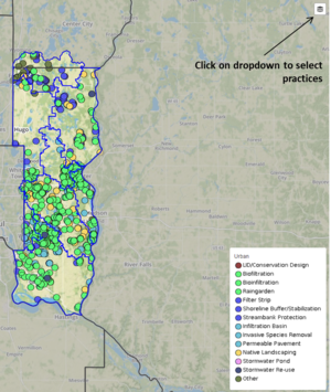
*[https://www.mapfeeder.net/wcdbmp/ Washington Conservation District] - (see image at right) | *[https://www.mapfeeder.net/wcdbmp/ Washington Conservation District] - (see image at right) | ||
*[http://www.minnehahacreek.org/maps Minnehaha Creek Watershed District] | *[http://www.minnehahacreek.org/maps Minnehaha Creek Watershed District] | ||
Revision as of 18:41, 20 July 2022

Enlarged screenshot of map showing management practices within the Washington Conservation District. Note the dropdown button in the upper right portion of the screen, which allows you to select the type of practice you are interested in.
This page includes links to other organization’s web sites in Minnesota that have virtual tours-good maps of their stormwater BMP’s.
- Dakota County Soil and Water Conservation District: Virtual Conservation Tour (2015): An annual Virtual Conservation Tour highlighting successful conservation projects installed by the Dakota County Soil and Water Conservation District (SWCD) in 2015.
- Mississippi Watershed Management Organization
- Ramsey-Washington Metro Watershed District
- Capitol Region Watershed District
- Washington Conservation District - (see image at right)
- Minnehaha Creek Watershed District
- Bassett Creek Watershed Management Commission
- Metro Blooms