Difference between revisions of "Watershed projects and virtual tours"
m |
m |
||
| (One intermediate revision by the same user not shown) | |||
| Line 16: | Line 16: | ||
[[Category:Level 2 - General information, reference, tables, images, and archives/General information]] | [[Category:Level 2 - General information, reference, tables, images, and archives/General information]] | ||
| + | [[Category:Level 2 - General information, reference, tables, images, and archives/Reference]] | ||
| + | [[Category:Level 2 - General information, reference, tables, images, and archives/Links]] | ||
| + | [[Category:Level 2 - Management/Watershed scale and treatment train]] | ||
Latest revision as of 22:46, 8 December 2022

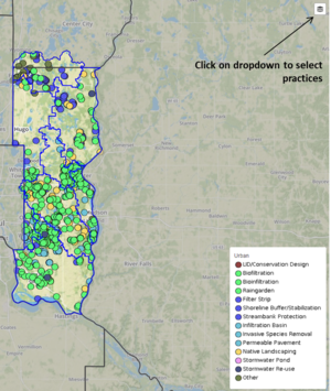
Enlarged screenshot of map showing management practices within the Washington Conservation District. Note the dropdown button in the upper right portion of the screen, which allows you to select the type of practice you are interested in.
This page includes links to other organization’s web sites in Minnesota that have virtual tours and/or good maps of their stormwater BMP’s. Most watershed organizations in Minnesota provide a page summarizing their projects. Link here to access a map showing watershed organizations in Minnesota.
- Dakota County Soil and Water Conservation District: Virtual Conservation Tour (2015): An annual Virtual Conservation Tour highlighting successful conservation projects installed by the Dakota County Soil and Water Conservation District (SWCD) in 2015.
- Mississippi Watershed Management Organization
- Ramsey-Washington Metro Watershed District
- Capitol Region Watershed District
- Washington Conservation District - (see image at right)
- Minnehaha Creek Watershed District
- Bassett Creek Watershed Management Commission
- Metro Blooms
- Comfort Lake Forest Lake Watershed District
- Rice Creek Watershed District
- South Washington Watershed District
Categories:
- Level 2 - General information, reference, tables, images, and archives/General information
- Level 2 - General information, reference, tables, images, and archives/Reference
- Level 2 - General information, reference, tables, images, and archives/Links
- Level 2 - Management/Watershed scale and treatment train
This page was last edited on 8 December 2022, at 22:46.