Difference between revisions of "Stormwater infiltration and setback (separation) distances"
(Created page with "File:Setback distances.jpg|300px|thumb|alt=schematic showing horizontal and vertical setback distances|<font size=3>and vertical separation distances of infiltration BMPs (S...") |
m |
||
| Line 1: | Line 1: | ||
| + | {{alert|This site is under construction. Anticipated completion date is May, 2015.|alert-under-construction}} | ||
| + | |||
[[File:Setback distances.jpg|300px|thumb|alt=schematic showing horizontal and vertical setback distances|<font size=3>and vertical separation distances of infiltration BMPs (Source: CDM Smith)</font size>]] | [[File:Setback distances.jpg|300px|thumb|alt=schematic showing horizontal and vertical setback distances|<font size=3>and vertical separation distances of infiltration BMPs (Source: CDM Smith)</font size>]] | ||
Revision as of 01:48, 27 May 2015
This site is under construction. Anticipated completion date is May, 2015.
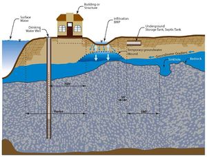
Separation distance is defined as the distance from the closest point of a BMP to the particular feature being considered. Recommended and REQUIRED separation distances for infiltration BMPs, shown in the figure to the right, are discussed below. Specific information on separation distances can be found on pages for individual BMPs. Note that all REQUIRED statements in this section refer to requirements contained in the NPDES/SDS Construction Stormwater (CSW) General Permit (CGP).
Vertical setback distances
Vertical separation distance is the vertical distance from the bottom of a BMP to the top of the feature of concern. The shortest vertical distance is used in measuring the separation distance.
Seasonally Saturated Soils
Under the CGP, a three (3) foot vertical separation is REQUIRED between the bottom of any infiltration BMP and the top of seasonally saturated soils. Seasonally saturated soil is defined as the highest seasonal elevation in the soil that is evidenced by the presence of redoximorphic features or other parameters as assessed by a soils specialist. The temporary [Stormwater infiltration and groundwater mounding groundwater mound] that develops below an operational infiltration BMP is not required to be a minimum of 3 feet below the bottom of the infiltration BMP. However, it is HIGHLY RECOMMENDED that this mound not penetrate into the infiltration BMP which could inhibit the pollutant removal within the media contained in the BMP. The base of the BMP may be raised to achieve the 3 foot separation.
Bedrock
Under the CGP a minimum 3 foot vertical separation is REQUIRED between the base of any constructed infiltration BMP and the top of the bedrock. The base of the BMP may be raised to achieve the 3 foot separation distance
Karst Bedrock
Karst topography is a geological formation shaped by the dissolution of a layer, or layers, of soluble bedrock. Groundwater in karst regions is particularly vulnerable to contamination. There is also concern about the formation of sinkholes resulting from focused infiltration. The CGP prohibits infiltration within areas that are 1,000 feet up gradient or 100 feet down gradient of an identified karst feature, unless approved by a local government with an approved Municipal Separate Storm Sewer System (MS4) NPDES permit. In addition, the 3 foot minimum separation to bedrock is applicable under the CGP. Additional detail on identifying and testing for Karst is detailed here.
