Difference between revisions of "Soils with low infiltration capacity"
m |
m |
||
| Line 3: | Line 3: | ||
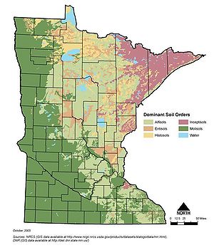
[[File:Minnesota dominant soil orders.jpg|thumb|300px|alt=statewide map illustrating karst areas|<font size=3>Statewide map of soil suborders. While soil infiltration rates vary widely within a suborder, infiltration rates tend to be lower on mollisols, histisols and vertisols compared to entisols, inceptisols, spodosols, and alfisols. Source: [http://www.extension.umn.edu/distribution/cropsystems/dc2331.html]</font size>]] | [[File:Minnesota dominant soil orders.jpg|thumb|300px|alt=statewide map illustrating karst areas|<font size=3>Statewide map of soil suborders. While soil infiltration rates vary widely within a suborder, infiltration rates tend to be lower on mollisols, histisols and vertisols compared to entisols, inceptisols, spodosols, and alfisols. Source: [http://www.extension.umn.edu/distribution/cropsystems/dc2331.html]</font size>]] | ||
| − | [[File:Minnesota soil survey status.png|thumb|300px|alt=statewide map illustrating karst areas|<font size=3>Statewide map illustrating the availability of digital soil surveys. Cook, Koochiching, portions of Pine, and portions of Crow Wing counties are the only remaining areas in Minnesota lacking digital soil surveys. Source: [http://www.bwsr.state.mn.us/maps/Website/Technical%20Services/Soils%20Hydrology%20Vegetaion/Soils_Survey_Status.pdf]</font size>]] | + | [[File:Minnesota soil survey status 2.png|thumb|300px|alt=statewide map illustrating karst areas|<font size=3>Statewide map illustrating the availability of digital soil surveys. Cook, Koochiching, portions of Pine, and portions of Crow Wing counties are the only remaining areas in Minnesota lacking digital soil surveys. Source: [http://www.bwsr.state.mn.us/maps/Website/Technical%20Services/Soils%20Hydrology%20Vegetaion/Soils_Survey_Status.pdf]</font size>]] |
Soils with low infiltration capacity are defined as soils with steady-state infiltration rates equal to or less than 0.06 inches per hour. [http://www.nrcs.usda.gov/wps/portal/nrcs/surveylist/soils/survey/state/?stateId=MN County soil surveys] are useful for initial screening to identify soils that may have low infiltration rates. Most county soil surveys are available digitally from the NRCS (National Resources Conservation Service). These surveys are not accurate enough to determine site-specific characteristics suitable for infiltration systems, so a [https://soilseries.sc.egov.usda.gov/osdname.asp detailed site analysis] should be performed for all proposed infiltration BMPs (Susilo, 2009). Additional information on soils can be found [http://stormwater.pca.state.mn.us/index.php/Soils_and_geology here]. | Soils with low infiltration capacity are defined as soils with steady-state infiltration rates equal to or less than 0.06 inches per hour. [http://www.nrcs.usda.gov/wps/portal/nrcs/surveylist/soils/survey/state/?stateId=MN County soil surveys] are useful for initial screening to identify soils that may have low infiltration rates. Most county soil surveys are available digitally from the NRCS (National Resources Conservation Service). These surveys are not accurate enough to determine site-specific characteristics suitable for infiltration systems, so a [https://soilseries.sc.egov.usda.gov/osdname.asp detailed site analysis] should be performed for all proposed infiltration BMPs (Susilo, 2009). Additional information on soils can be found [http://stormwater.pca.state.mn.us/index.php/Soils_and_geology here]. | ||
Revision as of 12:38, 3 June 2015
This site is under construction. Anticipated completion date is June, 2015.

Soils with low infiltration capacity are defined as soils with steady-state infiltration rates equal to or less than 0.06 inches per hour. County soil surveys are useful for initial screening to identify soils that may have low infiltration rates. Most county soil surveys are available digitally from the NRCS (National Resources Conservation Service). These surveys are not accurate enough to determine site-specific characteristics suitable for infiltration systems, so a detailed site analysis should be performed for all proposed infiltration BMPs (Susilo, 2009). Additional information on soils can be found here.
Stormwater management limitations in areas with low infiltration capacity soils generally preclude large-scale infiltration. These soils will typically be categorized under Hydrologic Soil Group (HSG) D. Design infiltration rates for these soils are conservative estimates of long-term, sustainable infiltration rates that have been documented in Minnesota. They are based on in-situ measurement within existing infiltration practices in Minnesota, rather than national numbers or rates based on laboratory columns.
The Construction general Permit (CGP) prohibits infiltration when an infiltration system will be constructed in areas of predominately Hydrologic Soil Group D (clay) soils unless allowed by a local unit of government with a current MS4 permit.