Difference between revisions of "Guidance and recommendations for conducting a higher level of engineering review for stormwater infiltration in DWSMAs and Wellhead Protection Areas"
m |
|||
| Line 5: | Line 5: | ||
==Description of Emergency Response Areas, DWSMAs, and vulnerability of DWSMAs== | ==Description of Emergency Response Areas, DWSMAs, and vulnerability of DWSMAs== | ||
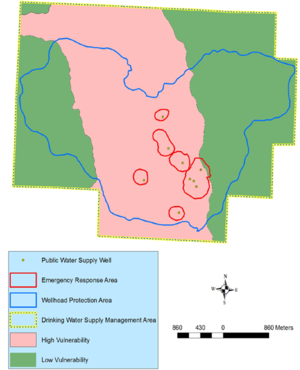
[[file:Wellhead protection example.png|300px|thumb|alt=image illustrating designations for public supply protection|<font size=3>Example map illustrating different protection designations for public supply wells with wellhead protection plans.</font size>]] | [[file:Wellhead protection example.png|300px|thumb|alt=image illustrating designations for public supply protection|<font size=3>Example map illustrating different protection designations for public supply wells with wellhead protection plans.</font size>]] | ||
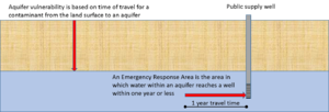
| + | [[File:ERA and vulnerability.png|300px|thumb|alt=schematic|<font size=3>Schematic illustrating the concepts of vulnerability and Emergency Response travel time.</font size>]] | ||
The figure at the right illustrates protection designations used to manage public water supply wells that have wellhead protection plans. | The figure at the right illustrates protection designations used to manage public water supply wells that have wellhead protection plans. | ||
*Drinking Water Supply Management Area (DWSMA) - the surface and subsurface area surrounding a public water supply well, including the wellhead protection area, that must be managed by the entity identified in a wellhead protection plan. This area is delineated using identifiable landmarks that reflect the scientifically calculated wellhead protection area boundaries as closely as possible. | *Drinking Water Supply Management Area (DWSMA) - the surface and subsurface area surrounding a public water supply well, including the wellhead protection area, that must be managed by the entity identified in a wellhead protection plan. This area is delineated using identifiable landmarks that reflect the scientifically calculated wellhead protection area boundaries as closely as possible. | ||
| Line 27: | Line 28: | ||
==Rationale for requiring a higher level of engineering review== | ==Rationale for requiring a higher level of engineering review== | ||
| + | There are two conditions in which infiltration is prohibited under the Construction Stormwater General Permit unless a higher level of engineering review is conducted and demonstrates that a functioning treatment system will prevent adverse impacts to groundwater. | ||
| + | #An Emergency Response Area (ERA) within a DWSMA classified as moderate vulnerability | ||
| + | #Outside of an ERA within a DWSMA classified as having high or very high vulnerability | ||
| − | + | It is important to understand limitations of maps depicting vulnerability. These maps are typically based on a limited number of borings that have been drilled and analyzed by geologic experts. Although in some locations there are numerous well boring logs, these logs are compiled by well drillers. Well logs therefore lack sufficient detail and expert interpretation to provide precise interpretations by geologic experts reviewing the boring logs. In addition, soils and geologic deposits can vary widely over short vertical and horizontal distances, particularly in more complex geologic settings. Consequently, classification of vulnerability represent best professional judgement. | |
| + | |||
| + | In the first condition above, a contaminant will potentially be transported to an underlying aquifer within a moderate time frame (e.g. one year to a decade). The concern is that contaminants reaching an aquifer within the ERA can be transported to a public supply well within a short time (less than one year). It is therefore important to collect additional information about the geologic materials overlying the aquifer or ensure a minimal risk of contaminant exposure in these settings. | ||
| + | |||
| + | In the second condition, contaminants will potentially be transported quickly to an aquifer, but the public supply well is outside the ERA. Determinations of ERA are based on sound geologic analysis and modeling, but other receptors beyond the public water supply well are not considered. Thus, private wells in these settings are at risk. Engineering review in this situation entails either conducting more detailed geologic analysis or modeling or conducting a well receptor survey. | ||
==Guidance and recommendations for conducting a higher level of engineering review== | ==Guidance and recommendations for conducting a higher level of engineering review== | ||
| + | The two conditions requiring higher levels of engineering review differ. | ||
| + | |||
| + | 1. '''Condition 1: Moderate vulnerability overlying an ERA'''. Because there is a high degree of certainty regarding the boundaries of the ERA, the purpose of the engineering review in this case is to conduct a detailed geologic analysis or provide reasonable assurances that risk of contaminant exposure is limited. | ||
| + | |||
*Identify hotspots | *Identify hotspots | ||
*Conduct a hydrogeologic assessment of the proposed location | *Conduct a hydrogeologic assessment of the proposed location | ||
Revision as of 19:59, 31 July 2018
This page is in development
The Construction Stormwater Permit requires a higher level on engineering review for proposed infiltration projects in areas overlying an Emergency Response Area (ERA) where the vulnerability of the DWSMA (Drinking Water Supply Management Area) is classified as moderate, or in areas outside the ERA where the vulnerability of the DWSMA (Drinking Water Supply Management Area) is classified as high or very high. This page provide guidance and recommendations for conducting a higher level of engineering review.
Contents
Description of Emergency Response Areas, DWSMAs, and vulnerability of DWSMAs
The figure at the right illustrates protection designations used to manage public water supply wells that have wellhead protection plans.
- Drinking Water Supply Management Area (DWSMA) - the surface and subsurface area surrounding a public water supply well, including the wellhead protection area, that must be managed by the entity identified in a wellhead protection plan. This area is delineated using identifiable landmarks that reflect the scientifically calculated wellhead protection area boundaries as closely as possible.
- Drinking Water Supply Management Area Vulnerability. An assessment of the likelihood that the aquifer within the DWSMA is subject to impact from overlying land and water uses. It is based upon criteria that are specified under Minnesota Rules, part 4720.5210, subpart 3.
- Emergency Response Area (ERA). The part of the wellhead protection area that is defined by a one-year time of travel within the aquifer that is used by the public water supply well (Minnesota Rules, part 4720.5250, subpart 3). It is used to set priorities for managing potential contamination sources within the DWSMA. This area is particularly relevant for assessing impacts from potential sources of pathogen contamination because this time of travel is believed to closely correspond with the survival period of many pathogens.
- Wellhead Protection Area (WHPA) – the surface and subsurface area surrounding a well or well field that supplies a public water system, through which contaminants are likely to move toward and reach the well or well field (Minnesota Statutes, section 103I.005, subdivision 24).
A public water supply well is vulnerable if:
- the well water contains ten (10) milligrams per liter or more nitrate plus nitrite nitrogen;
- the well water contains quantifiable levels of pathogens as defined in part 7040.0100, subpart 26, or chemical compounds that indicate groundwater degradation as defined in Minnesota Statutes, section 103H.005, subdivision 6;
- the well water contains one tritium unit or more when measured with an enriched tritium detection method; or
- an enriched tritium analysis of the well water has not been performed within the past ten years; and
- information on the well construction is not available; or
- the geological material from the land surface to where the groundwater enters the public water supply well is:
- fractured bedrock;
- solution weathered bedrock;
- sandstone bedrock;
- unconsolidated material 0.062 millimeters (fine sand) or larger; or
- a combination of the materials specified in units (a) to (d).
Five classes of vulnerability exist: very low, low, moderate, high, and very high. Within high and very high vulnerability designations, contaminants at the land surface have the potential to move quickly to the underlying aquifer.
Rationale for requiring a higher level of engineering review
There are two conditions in which infiltration is prohibited under the Construction Stormwater General Permit unless a higher level of engineering review is conducted and demonstrates that a functioning treatment system will prevent adverse impacts to groundwater.
- An Emergency Response Area (ERA) within a DWSMA classified as moderate vulnerability
- Outside of an ERA within a DWSMA classified as having high or very high vulnerability
It is important to understand limitations of maps depicting vulnerability. These maps are typically based on a limited number of borings that have been drilled and analyzed by geologic experts. Although in some locations there are numerous well boring logs, these logs are compiled by well drillers. Well logs therefore lack sufficient detail and expert interpretation to provide precise interpretations by geologic experts reviewing the boring logs. In addition, soils and geologic deposits can vary widely over short vertical and horizontal distances, particularly in more complex geologic settings. Consequently, classification of vulnerability represent best professional judgement.
In the first condition above, a contaminant will potentially be transported to an underlying aquifer within a moderate time frame (e.g. one year to a decade). The concern is that contaminants reaching an aquifer within the ERA can be transported to a public supply well within a short time (less than one year). It is therefore important to collect additional information about the geologic materials overlying the aquifer or ensure a minimal risk of contaminant exposure in these settings.
In the second condition, contaminants will potentially be transported quickly to an aquifer, but the public supply well is outside the ERA. Determinations of ERA are based on sound geologic analysis and modeling, but other receptors beyond the public water supply well are not considered. Thus, private wells in these settings are at risk. Engineering review in this situation entails either conducting more detailed geologic analysis or modeling or conducting a well receptor survey.
Guidance and recommendations for conducting a higher level of engineering review
The two conditions requiring higher levels of engineering review differ.
1. Condition 1: Moderate vulnerability overlying an ERA. Because there is a high degree of certainty regarding the boundaries of the ERA, the purpose of the engineering review in this case is to conduct a detailed geologic analysis or provide reasonable assurances that risk of contaminant exposure is limited.
- Identify hotspots
- Conduct a hydrogeologic assessment of the proposed location
- Evaluate future land use in the area contributing to the proposed infiltration practice

