Difference between revisions of "Precipitation"
| Line 3: | Line 3: | ||
[[File:Minnesota normal annual snowfall.png|center|thumb|300px|alt=map showing normal annual snowfall in Minnesota|<font size=3>Normal annual snowfall in Minnesota. Snowfall is greatest in the northeastern part of the state.</font size>]] | [[File:Minnesota normal annual snowfall.png|center|thumb|300px|alt=map showing normal annual snowfall in Minnesota|<font size=3>Normal annual snowfall in Minnesota. Snowfall is greatest in the northeastern part of the state.</font size>]] | ||
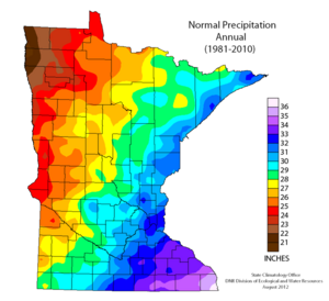
| − | [[File:Precipitation 1981 to 2010.png|thumb|300px|alt=map showing normal annual precipitation across Minnesota.|<font size=3>Normal annual precipitation across Minnesota for the period 1981 to 2010. Generally, precipitation increases from west to east.</font size>]] | + | [[File:Precipitation 1981 to 2010.png|left|thumb|300px|alt=map showing normal annual precipitation across Minnesota.|<font size=3>Normal annual precipitation across Minnesota for the period 1981 to 2010. Generally, precipitation increases from west to east.</font size>]] |
Revision as of 19:25, 30 July 2015
File:Minnesota normal annual snowfall.png
Normal annual snowfall in Minnesota. Snowfall is greatest in the northeastern part of the state.
