Navigation
Main page
Table of contents
Index (Categories)
What's new
Response to comments
Future updates
Events
In the News
Funding
Recent changes
Help
Export to pdf
Tools
Special pages
Printable version
MPCA Links
MPCA Homepage
Stormwater
Policies / Disclaimers
Minnesota Stormwater Manual
Search Help
Log in
Search:
Search
Gallery of new files
Special:NewFiles
This special page shows the last uploaded files.
Filter
Filename (or a part of it):
IP address or username
Show uploads by bots
Media type:
3D
Audio
Bitmap images
Compressed formats
Drawings (vector images)
Executables
Office
Rich media
Textual
Unknown
Videos
From date:
To date:
Search
Litter animal waste control.jpg
PLeegar
16:19, 23 January 2013
150 × 113; 4 KB
Fertilizer pesticide management.jpg
PLeegar
16:19, 23 January 2013
150 × 112; 5 KB
Narrow street example.jpg
PLeegar
16:07, 23 January 2013
1,024 × 768; 661 KB
Better site design practices.jpg
Mtrojan
14:19, 23 January 2013
1,041 × 947; 117 KB
Better site design practices.png
Mtrojan
14:12, 23 January 2013
909 × 974; 234 KB
Changes in cross section during 2002.png
PLeegar
15:45, 17 January 2013
750 × 564; 63 KB
Water depth during September 5 event.png
PLeegar
15:43, 17 January 2013
868 × 643; 64 KB
Water depth during June 21 event.png
PLeegar
15:42, 17 January 2013
869 × 643; 36 KB
Water depth during August 16 event.png
PLeegar
15:41, 17 January 2013
868 × 642; 36 KB
Peak discharge during a wet year.png
PLeegar
15:28, 17 January 2013
900 × 627; 49 KB
100 year 24 hour event.png
PLeegar
14:55, 17 January 2013
866 × 594; 34 KB
10 year 24 hour event.png
PLeegar
14:54, 17 January 2013
750 × 512; 46 KB
2 year 24 hour event.png
PLeegar
14:54, 17 January 2013
871 × 590; 34 KB
1 year 24 hour event.png
PLeegar
14:54, 17 January 2013
871 × 591; 36 KB
Downstream channel sross section.png
PLeegar
14:42, 17 January 2013
750 × 526; 86 KB
Test channel grain size distribution.png
PLeegar
14:37, 17 January 2013
905 × 1,251; 223 KB
Impaired lakes and wetlands 2009.png
Mtrojan
14:14, 17 January 2013
763 × 1,020; 488 KB
Impaired streams 2009.png
Mtrojan
14:11, 17 January 2013
738 × 980; 458 KB
Grapic representation of sizing criteria.png
Mtrojan
22:00, 16 January 2013
728 × 731; 130 KB
AppOTable8.png
PLeegar
20:12, 16 January 2013
775 × 466; 39 KB
Approximate detention basin routing.png
PLeegar
19:48, 16 January 2013
1,500 × 1,122; 1.02 MB
Detention time vs discharge ratios.png
PLeegar
19:44, 16 January 2013
1,500 × 1,044; 490 KB
Unit peak discharge Type 2 rainfall distribution.png
PLeegar
19:38, 16 January 2013
1,500 × 1,131; 314 KB
Example code.png
Mtrojan
19:31, 15 January 2013
1,254 × 560; 235 KB
Rooftop disconnection credit example.png
Mtrojan
22:02, 14 January 2013
428 × 1,092; 254 KB
Surface impervious cover disconnection credit example.png
Mtrojan
22:02, 14 January 2013
384 × 1,093; 241 KB
Grass channel credit example.png
Mtrojan
22:02, 14 January 2013
384 × 1,092; 217 KB
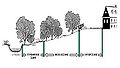
Drainage to stream, wetland, shoreline buffer credit example.png
Mtrojan
22:01, 14 January 2013
384 × 1,096; 203 KB
Site reforestation credit example.png
Mtrojan
20:50, 14 January 2013
388 × 1,088; 121 KB
Natural area conservation credit example.png
Mtrojan
20:32, 14 January 2013
384 × 1,090; 215 KB
Plot impervious vs watershed inches.png
PLeegar
19:29, 14 January 2013
1,008 × 553; 97 KB
Basic water quality sizing for ponds.jpg
PLeegar
19:24, 14 January 2013
904 × 497; 62 KB
Schematic of total storage volume.jpg
PLeegar
19:18, 14 January 2013
935 × 466; 37 KB
Examples of landscaped islands.jpg
Mtrojan
22:15, 10 January 2013
962 × 692; 84 KB
Vegetation in a landscaped island.jpg
Mtrojan
22:10, 10 January 2013
961 × 381; 62 KB
Example of a short driveway.jpg
Mtrojan
22:07, 10 January 2013
963 × 497; 68 KB
Sidewalk draining to adjacent vegetation.jpg
Mtrojan
22:06, 10 January 2013
957 × 722; 59 KB
Turn around options residential streets.jpg
Mtrojan
22:05, 10 January 2013
958 × 376; 35 KB
Example of traditional and bsd road designs.jpg
Mtrojan
22:03, 10 January 2013
961 × 451; 38 KB
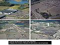
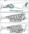
Comparison of predevelopment, conventional and open space designs.jpg
Mtrojan
22:01, 10 January 2013
608 × 723; 66 KB
Schematic of conventional subdivision.jpg
Mtrojan
21:56, 10 January 2013
962 × 718; 109 KB
Three zone stream buffer system.jpg
Mtrojan
21:54, 10 January 2013
959 × 540; 37 KB
Potential planting areas at development site.jpg
Mtrojan
21:52, 10 January 2013
958 × 720; 117 KB
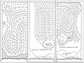
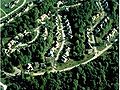
Residential subdivision showing preservation undistrurbed areas.jpg
Mtrojan
21:50, 10 January 2013
958 × 720; 100 KB
Infrequently filled parking lots.jpg
Mtrojan
21:18, 10 January 2013
961 × 722; 100 KB
Empty metro shopping parking lots.jpg
Mtrojan
21:18, 10 January 2013
961 × 721; 134 KB
Better site design principles.jpg
Mtrojan
21:15, 10 January 2013
1,127 × 612; 69 KB
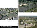
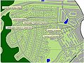
Alternative parking lot collection and treatment.jpg
Mtrojan
21:15, 10 January 2013
959 × 719; 106 KB
Alternative overflow seldom used parking.jpg
Mtrojan
21:15, 10 January 2013
961 × 721; 116 KB
Alternative commercial parking lot designl.jpg
Mtrojan
21:15, 10 January 2013
961 × 721; 142 KB
(
newest
|
oldest
) View (
newer 50
|
older 50
) (
20
|
50
|
100
|
250
|
500
)
Search:
Search
Privacy policy