Requirements, recommendations and information for using bioretention with no underdrain BMPs in the MIDS calculator
This site is currently undergoing revision. For more information, open this link.
The anticipated construction period for this page is through August, 2014
The anticipated construction period for this page is through August, 2014
For a bioinfiltration system, all stormwater runoff captured by the BMP is infiltrated into the underlying soil between rain events. All pollutants in the captured water are credited as being reduced. Pollutants in the stormwater that bypasses the BMP are not reduced.
MIDS calculator user inputs for bioinfiltration
For bioinfiltration systems, the user must input the following parameters to calculate the volume and pollutant load reductions associated with the BMP.
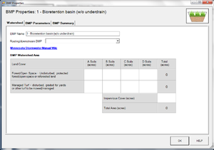
- Watershed tab
- BMP Name: this cell is auto-filled but can be changed by the user.
- Routing/downstream BMP: if this BMP is part of a treatment train and water is being routed from this BMP to another BMP, the user selects the name of the BMP from the dropdown box to which water is being routed. All water must be routed to a single downstream BMP. Note that the User must include the BMP receiving the routed water in the Schematic or the BMP will not appear in the dropdown box.
- BMP Watershed Area: BMP watershed areas are the areas draining directly to the BMP. Values can be added for four soil types (Hydrologic Soil Groups (HSG) A, B, C, D) and for three Land Cover types (Forest/Open Space, Managed Turf and impervious). The surface area of the BMP should be included as a managed turf land cover under the hydrologic soils group of the native soils located under the BMP. Units are in acres.
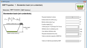
- BMP Parameters tab:
- Overflow surface area (AO): This is the surface area at the lowest outlet point from the BMP. The user inputs this value in square feet.
- Media surface area (AM): This is the surface area at the bottom of the ponded water within the BMP. Therefore, this is the area at the surface of the media. The user inputs this value in square feet.
- Overflow depth (DO): This is the maximum depth of ponded water within the BMP (i.e., distance from the overflow elevation to the top of the soil or media). The user inputs this value in feet. The maximum value allowed for this depth is 1.5 feet or a depth defined by the requirement to drain ponded water within 48 hours, whichever is less.
- Underlying soil - Hydrologic Soil Group: The user selects the most restrictive soil (lowest hydraulic conductivity) within three feet of the soil/media interface in the bioinfiltration basin. There are 14 soil options that fall into 4 different Hydrologic Soil Groups (Hydrologic Soil Group (HSG) A, B, C, or D) for the user. Once a soil type is selected, the corresponding infiltration rate will populate in the Infiltration rate of underlying soils field. The user may also select User Defined. This selection will activate the User Defined Infiltration Rate cell allowing the user to enter a different value from the values in the predefined selection list. The maximum allowable infiltration rate is 1.63 inches per hour.
- Required drawdown time (hrs): This is the time in which the stormwater captured by and ponded within the BMP must drain into the underlying soil/media. The user selects from predefined values of 48 or 24 hours. The MPCA Construction Stormwater General Permit requires drawdown within 48 hours, but 24 hours is highly recommended when discharges are to a trout stream. The calculator uses the underlying soil infiltration rate and the overflow depth to check if the BMP is meeting the drawdown time requirement. The user will encounter an error and be required to enter a new overflow depth if the water stored in the BMP cannot drawdown in the required time.
- BMP Summary Tab: The BMP Summary tab summarizes the volume and pollutant reductions provided by the specific BMP. It details the performance goal volume reductions and annual average volume, dissolved P, particulate P, and TSS load reductions. Included in the summary are the total volume and pollutant loads received by the BMP from its direct watershed, from upstream BMPs and a combined value of the two. Also included in the summary, are the volume and pollutant load reductions provided by the BMP, in addition to the volume and pollutant loads that exit the BMP through the outflow. This outflow load and volume is what is routed to the downstream BMP if one is defined in the Watershed tab. Finally, percent reductions are provided for the percent of the performance goal achieved, percent annual runoff volume retained, total percent annual particulate phosphorus reduction, total percent annual dissolved phosphorus reduction, total percent annual TP reduction, and total percent annual TSS reduction.


