Navigation
Main page
Table of contents
Index (Categories)
What's new
Response to comments
Future updates
Events
In the News
Funding
Recent changes
Help
Export to pdf
Tools
Special pages
MPCA Links
MPCA Homepage
Stormwater
Policies / Disclaimers
Minnesota Stormwater Manual
Search Help
Log in
Search:
Search
Gallery of new files
Special:NewFiles
This special page shows the last uploaded files.
Filter
Filename (or a part of it):
IP address or username
Show uploads by bots
Media type:
3D
Audio
Bitmap images
Compressed formats
Drawings (vector images)
Executables
Office
Rich media
Textual
Unknown
Videos
From date:
To date:
Search
Contaminant feature.png
Mtrojan
18:38, 3 June 2016
1,238 × 560; 152 KB
Checklist for potentially contaminated sites.xlsx
Mtrojan
20:46, 1 June 2016
; 18 KB
Permeable pavement icon.png
Mtrojan
19:45, 31 May 2016
722 × 747; 534 KB
Swale check icon.png
Mtrojan
19:39, 31 May 2016
1,301 × 794; 700 KB
Dry Swale with Check Dam.PNG
PLeegar
18:11, 31 May 2016
901 × 513; 407 KB
Underground infiltration icon.png
Mtrojan
14:55, 31 May 2016
1,237 × 626; 552 KB
Tree trench icon.png
Mtrojan
14:54, 31 May 2016
915 × 465; 441 KB
Tree box icon.png
Mtrojan
14:54, 31 May 2016
1,198 × 649; 599 KB
Infiltration trench icon.png
Mtrojan
14:53, 31 May 2016
908 × 660; 606 KB
Dry well icon.png
Mtrojan
14:53, 31 May 2016
551 × 720; 280 KB
Infiltration basin icon.png
Mtrojan
14:42, 31 May 2016
886 × 336; 240 KB
Error creating thumbnail: File with dimensions greater than 12.5 MP
Infiltration Basin.png
PLeegar
19:42, 26 May 2016
5,274 × 3,359; 320 KB
Tree Trench3.jpg
PLeegar
18:55, 26 May 2016
1,882 × 921; 1.28 MB
Error creating thumbnail: File with dimensions greater than 12.5 MP
Permeable Paver.png
PLeegar
18:52, 26 May 2016
5,100 × 3,300; 540 KB
Dry Swale and Check Dam.jpg
PLeegar
18:48, 26 May 2016
1,266 × 808; 1.3 MB
Error creating thumbnail: File with dimensions greater than 12.5 MP
Underground Infiltration System.png
PLeegar
18:45, 26 May 2016
5,100 × 3,300; 692 KB
Error creating thumbnail: File with dimensions greater than 12.5 MP
Dry Well.png
PLeegar
18:41, 26 May 2016
5,100 × 3,300; 472 KB
Error creating thumbnail: File with dimensions greater than 12.5 MP
Infiltration Trench.png
PLeegar
18:38, 26 May 2016
5,100 × 3,300; 1.08 MB
Error creating thumbnail: File with dimensions greater than 12.5 MP
Bioinfiltration Basin.png
PLeegar
18:30, 26 May 2016
5,274 × 3,359; 469 KB
Calculator screenshot 2.png
Mtrojan
20:55, 25 May 2016
1,189 × 925; 376 KB
Calculator screenshot.png
Mtrojan
20:23, 25 May 2016
1,155 × 871; 318 KB
Screening assessment example 4.png
Mtrojan
16:19, 25 May 2016
1,453 × 1,000; 3.65 MB
CSW search tool result set.PNG
PLeegar
16:07, 25 May 2016
1,231 × 827; 58 KB
CSW search tool.PNG
PLeegar
16:00, 25 May 2016
1,147 × 650; 38 KB
Screening assessment example 3.png
Mtrojan
15:38, 25 May 2016
1,190 × 922; 2.17 MB
Screening assessment example 2.png
Mtrojan
14:44, 25 May 2016
1,280 × 857; 2.71 MB
Screening assessment example 1.png
Mtrojan
13:24, 25 May 2016
1,474 × 1,017; 4.04 MB
Mismanaged drums.png
Mtrojan
20:36, 24 May 2016
1,088 × 725; 832 KB
Stained soil.png
Mtrojan
20:32, 24 May 2016
901 × 671; 1.79 MB
Soil pile.png
Mtrojan
20:29, 24 May 2016
1,085 × 546; 1.41 MB
Port for underground tank.png
Mtrojan
20:16, 24 May 2016
976 × 824; 1.68 MB
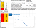
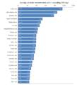
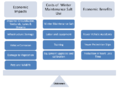
Cost Considerations Related to Winter Maintenance Salt Use.PNG
PLeegar
21:52, 16 May 2016
744 × 546; 44 KB
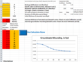
Implementation Strategy to meet the TCMA Chloride TMDLs.PNG
PLeegar
20:52, 16 May 2016
724 × 424; 340 KB
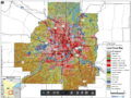
Model schematic for allowable runoff load for stream TMDLs in the TCMA.PNG
PLeegar
18:39, 16 May 2016
703 × 438; 159 KB
Model schematic for allowable runoff load for lake and wetland TMDLs in the TCMA.PNG
PLeegar
18:35, 16 May 2016
727 × 450; 182 KB
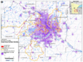
Comparison of Impaired Streams in the TCMA 2003-2013.PNG
PLeegar
16:23, 16 May 2016
757 × 758; 45 KB
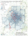
Comparison of Impaired Lakes and Wetlands in the TCMA from 2003-2013.PNG
PLeegar
16:04, 16 May 2016
696 × 767; 48 KB
Percent Impervious in the TCMA.PNG
PLeegar
16:00, 16 May 2016
922 × 692; 1.33 MB
Chloride Impairments and Road Density in the TCMA.PNG
PLeegar
15:54, 16 May 2016
614 × 793; 989 KB
Land Use in the TCMA.PNG
PLeegar
15:46, 16 May 2016
1,164 × 869; 1.66 MB
P1000870.JPG
Mtrojan
17:58, 11 May 2016
3,072 × 2,304; 2.8 MB
Picture 067.JPG
PLeegar
18:51, 5 May 2016
1,496 × 1,122; 1.18 MB
Picture 020.JPG
PLeegar
18:35, 5 May 2016
1,200 × 900; 925 KB
Wetland 2.jpg
PLeegar
18:33, 5 May 2016
1,128 × 610; 180 KB
DSCN8528.JPG
PLeegar
18:31, 5 May 2016
2,592 × 1,944; 4.11 MB
C00026211 025.JPG
PLeegar
18:29, 5 May 2016
1,600 × 1,200; 1.57 MB
Stabilization BMP.png
Mtrojan
16:41, 5 May 2016
902 × 575; 1.09 MB
IMG 1846.jpg
PLeegar
15:38, 5 May 2016
1,024 × 768; 241 KB
DSC00241.JPG
PLeegar
15:35, 5 May 2016
2,592 × 1,944; 2.93 MB
DSC00240.JPG
PLeegar
15:34, 5 May 2016
2,592 × 1,944; 2.9 MB
(
newest
|
oldest
) View (
newer 50
|
older 50
) (
20
|
50
|
100
|
250
|
500
)
Search:
Search
Privacy policy