![]()
Search results
Create the page "Tables" on this wiki! See also the search results found.

File:Stormwater-benton-graniteledge.pdf [[Category:Level 2 - General information, reference, tables, images, and archives/Archives]](53 KB) - 17:26, 16 August 2022File:Stormwater-crow-otsego.pdf [[Category:Level 2 - General information, reference, tables, images, and archives/Archives]](77 KB) - 17:35, 16 August 2022File:Stormwater-misc-mnstate.pdf [[Category:Level 2 - General information, reference, tables, images, and archives/Archives]](84 KB) - 17:42, 16 August 2022File:P-gen3-14a.pdf [[Category:Level 2 - General information, reference, tables, images, and archives/Archives]](9.04 MB) - 16:03, 16 August 2022File:Stormwater-river-marshall.pdf [[Category:Level 2 - General information, reference, tables, images, and archives/Archives]](29 KB) - 17:50, 16 August 2022
File:StormTrap underground storage vault for water stormwater reuse as irrigation.png [[Category:Level 3 - General information, reference, tables, images, and archives/Images/Case studies photos]] [[Category:Level 3 - General information, reference, tables, images, and archives/Images/Infiltration (trench/basin) photos]](1,432 × 1,067 (4.3 MB)) - 14:27, 25 February 2023
File:Infiltration soil being carefully placed to avoid compaction.png [[Category:Level 3 - General information, reference, tables, images, and archives/Images/Case studies photos]] [[Category:Level 3 - General information, reference, tables, images, and archives/Images/Infiltration (trench/basin) photos]](1,432 × 1,067 (3.64 MB)) - 14:27, 25 February 2023
File:Modular Block Sediment Trap.png [[Category:Level 3 - General information, reference, tables, images, and archives/Images/Case studies photos]] [[Category:Level 3 - General information, reference, tables, images, and archives/Images/Infiltration (trench/basin) photos]](1,428 × 808 (2.9 MB)) - 14:27, 25 February 2023
File:Infiltration basin with rough grading complete.png [[Category:Level 3 - General information, reference, tables, images, and archives/Images/Case studies photos]] [[Category:Level 3 - General information, reference, tables, images, and archives/Images/Infiltration (trench/basin) photos]](1,428 × 808 (2.64 MB)) - 14:28, 25 February 2023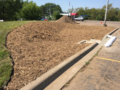
File:Infiltration basin before planting.png [[Category:Level 3 - General information, reference, tables, images, and archives/Images/Case studies photos]] [[Category:Level 3 - General information, reference, tables, images, and archives/Images/Infiltration (trench/basin) photos]](1,024 × 768 (2.1 MB)) - 14:28, 25 February 2023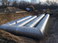
File:Contech infiltration system in native sandy soils.png [[Category:Level 3 - General information, reference, tables, images, and archives/Images/Case studies photos]] [[Category:Level 3 - General information, reference, tables, images, and archives/Images/Infiltration (trench/basin) photos]](1,432 × 1,067 (4.06 MB)) - 01:48, 8 February 2023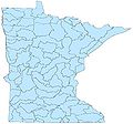
File:Minnesota's major watersheds.jpg [[Category:Level 3 - General information, reference, tables, images, and archives/Images/Maps]](910 × 852 (70 KB)) - 01:58, 14 December 2022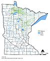
File:Minnesota lakes, rivers and wetlands.jpg [[Category:Level 3 - General information, reference, tables, images, and archives/Images/Maps]](846 × 1,018 (115 KB)) - 01:54, 14 December 2022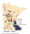
File:Nitrate distribution in MN.png [[Category:Level 3 - General information, reference, tables, images, and archives/Images/Maps]](524 × 591 (234 KB)) - 17:46, 20 December 2022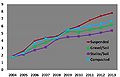
File:Planting technique effect on trunk diameter of Bosque elm.jpg [[Category:Level 3 - General information, reference, tables, images, and archives/Images/Graphs]](729 × 468 (25 KB)) - 20:52, 15 December 2022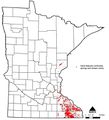
File:Statewide karst areas.jpg [[Category:Level 3 - General information, reference, tables, images, and archives/Images/Maps]](765 × 842 (61 KB)) - 02:00, 14 December 2022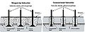
File:Schematic of winged tip and conventional tip subsoiler.jpg [[Category:Level 3 - General information, reference, tables, images, and archives/Images/Schematics]](501 × 190 (18 KB)) - 14:24, 13 December 2022
File:Cap region figure 1.png [[Category:Level 3 - General information, reference, tables, images, and archives/Images/Schematics]](923 × 605 (94 KB)) - 17:35, 15 December 2022
File:Example 1.63 in hr.jpg [[Category:Level 3 - General information, reference, tables, images, and archives/Images/Graphs]](1,001 × 603 (62 KB)) - 20:57, 15 December 2022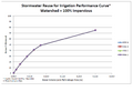
File:Stormwater reuse for irrigation performance curve – watershed 100 percent impervious.png [[Category:Level 3 - General information, reference, tables, images, and archives/Images/Graphs]](896 × 614 (38 KB)) - 20:54, 15 December 2022


