![]()
Search results
Create the page "Tables" on this wiki! See also the search results found.
File:Nitrate distribution in MN.png [[Category:Level 3 - General information, reference, tables, images, and archives/Images/Maps]](524 × 591 (234 KB)) - 17:46, 20 December 2022
File:PSD curve.png [[Category:Level 3 - General information, reference, tables, images, and archives/Images/Graphs]](1,263 × 772 (365 KB)) - 17:43, 20 December 2022
File:Stormwater reuse for irrigation performance curve – watershed 10 percent impervious.png [[Category:Level 3 - General information, reference, tables, images, and archives/Images/Graphs]](901 × 614 (44 KB)) - 20:54, 15 December 2022
File:Cap region figure 1.png [[Category:Level 3 - General information, reference, tables, images, and archives/Images/Schematics]](923 × 605 (94 KB)) - 17:35, 15 December 2022
File:Example 1.63 in hr.jpg [[Category:Level 3 - General information, reference, tables, images, and archives/Images/Graphs]](1,001 × 603 (62 KB)) - 20:57, 15 December 2022
File:Minnesota Anoka sand plain.jpg [[Category:Level 3 - General information, reference, tables, images, and archives/Images/Maps]](840 × 1,012 (64 KB)) - 01:50, 14 December 2022
File:Brown's creek overview map.png [[Category:Level 3 - General information, reference, tables, images, and archives/Images/Maps]](1,287 × 810 (923 KB)) - 01:48, 14 December 2022
File:Stormwater reuse for irrigation performance curve – watershed 30 percent impervious.png [[Category:Level 3 - General information, reference, tables, images, and archives/Images/Graphs]](914 × 634 (46 KB)) - 20:54, 15 December 2022
File:Infiltration rate 0.2 inch hr.jpg [[Category:Level 3 - General information, reference, tables, images, and archives/Images/Graphs]](975 × 581 (73 KB)) - 20:57, 15 December 2022
File:Minnesota bedrock geology.png [[Category:Level 3 - General information, reference, tables, images, and archives/Images/Maps]](1,417 × 754 (692 KB)) - 01:50, 14 December 2022
File:Tanner alum treatment schematic.png [[Category:Level 3 - General information, reference, tables, images, and archives/Images/Schematics]](758 × 1,024 (545 KB)) - 20:59, 15 December 2022
File:Illustration of model calibration2.jpg [[Category:Level 3 - General information, reference, tables, images, and archives/Images/Illustrations]](1,151 × 409 (36 KB)) - 18:37, 13 December 2022
File:Lunds.png [[Category:Level 3 - General information, reference, tables, images, and archives/Images/Schematics]](806 × 541 (315 KB)) - 17:57, 20 December 2022
File:Minnesota Level III and IV Ecoregions.jpg [[Category:Level 3 - General information, reference, tables, images, and archives/Images/Maps]](414 × 600 (42 KB)) - 01:55, 14 December 2022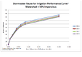
File:Stormwater reuse for irrigation performance curve – watershed 50 percent impervious.png [[Category:Level 3 - General information, reference, tables, images, and archives/Images/Graphs]](884 × 614 (42 KB)) - 20:54, 15 December 2022
File:Minnesota bedrock outcrops.jpg [[Category:Level 3 - General information, reference, tables, images, and archives/Images/Maps]](831 × 1,009 (69 KB)) - 01:53, 14 December 2022
File:Example plume 2.png [[Category:Level 3 - General information, reference, tables, images, and archives/Images/Maps]](1,282 × 678 (369 KB)) - 18:16, 20 December 2022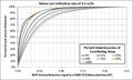
File:Infiltration rate 0.3 inch hr.jpg [[Category:Level 3 - General information, reference, tables, images, and archives/Images/Graphs]](975 × 581 (72 KB)) - 20:57, 15 December 2022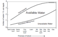
File:Available water capacity.png [[Category:Level 3 - General information, reference, tables, images, and archives/Images/Graphs]](781 × 510 (124 KB)) - 02:27, 15 December 2022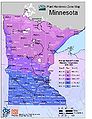
File:Plant hardiness zone map.jpg [[Category:Level 3 - General information, reference, tables, images, and archives/Images/Maps]](615 × 797 (86 KB)) - 01:59, 14 December 2022


