![]()
Search results
Create the page "Tables" on this wiki! See also the search results found.
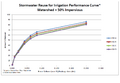
File:Stormwater reuse for irrigation performance curve – watershed 50 percent impervious.png [[Category:Level 3 - General information, reference, tables, images, and archives/Images/Graphs]](884 × 614 (42 KB)) - 20:54, 15 December 2022
File:Tanner alum treatment schematic.png [[Category:Level 3 - General information, reference, tables, images, and archives/Images/Schematics]](758 × 1,024 (545 KB)) - 20:59, 15 December 2022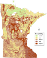
File:Minnesota groundwater sensitivity.png [[Category:Level 3 - General information, reference, tables, images, and archives/Images/Maps]](550 × 691 (586 KB)) - 18:19, 20 December 2022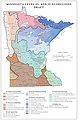
File:Minnesota Level III and IV Ecoregions.jpg [[Category:Level 3 - General information, reference, tables, images, and archives/Images/Maps]](414 × 600 (42 KB)) - 01:55, 14 December 2022
File:Minnesota bedrock outcrops.jpg [[Category:Level 3 - General information, reference, tables, images, and archives/Images/Maps]](831 × 1,009 (69 KB)) - 01:53, 14 December 2022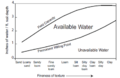
File:Available water capacity.png [[Category:Level 3 - General information, reference, tables, images, and archives/Images/Graphs]](781 × 510 (124 KB)) - 02:27, 15 December 2022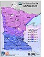
File:Plant hardiness zone map.jpg [[Category:Level 3 - General information, reference, tables, images, and archives/Images/Maps]](615 × 797 (86 KB)) - 01:59, 14 December 2022
File:Example 0.3 in hr.jpg [[Category:Level 3 - General information, reference, tables, images, and archives/Images/Graphs]](995 × 601 (70 KB)) - 20:56, 15 December 2022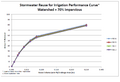
File:Stormwater reuse for irrigation performance curve – watershed 70 percent impervious.png [[Category:Level 3 - General information, reference, tables, images, and archives/Images/Graphs]](902 × 614 (41 KB)) - 20:54, 15 December 2022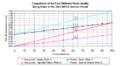
File:Plot impervious vs water quality volume inches.png [[Category:Level 3 - General information, reference, tables, images, and archives/Images/Graphs]](1,007 × 552 (126 KB)) - 20:52, 15 December 2022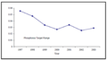
File:Tanner phosphorus reduction graph.png [[Category:Level 3 - General information, reference, tables, images, and archives/Images/Graphs]](1,133 × 632 (80 KB)) - 21:01, 15 December 2022
File:Phosphorus impairments.png [[Category:Level 3 - General information, reference, tables, images, and archives/Images/Maps]](867 × 992 (143 KB)) - 21:16, 15 December 2022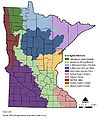
File:Minnesota ecoregion sections.jpg [[Category:Level 3 - General information, reference, tables, images, and archives/Images/Maps]](843 × 1,009 (81 KB)) - 01:53, 14 December 2022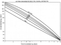
File:Unit peak discharge Type 2 rainfall distribution.png [[Category:Level 3 - General information, reference, tables, images, and archives/Images/Graphs]](1,500 × 1,131 (314 KB)) - 20:55, 15 December 2022
File:Chloride concentrations in runoff.png [[Category:Level 3 - General information, reference, tables, images, and archives/Images/Graphs]](1,209 × 642 (71 KB)) - 17:47, 20 December 2022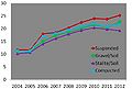
File:Planting technique effect on height of Bosque elm.jpg [[Category:Level 3 - General information, reference, tables, images, and archives/Images/Graphs]](738 × 496 (29 KB)) - 20:51, 15 December 2022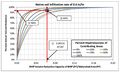
File:Example 0.6 in hr.jpg [[Category:Level 3 - General information, reference, tables, images, and archives/Images/Graphs]](997 × 601 (68 KB)) - 20:57, 15 December 2022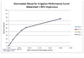
File:Stormwater reuse for irrigation performance curve – watershed 90 percent impervious.png [[Category:Level 3 - General information, reference, tables, images, and archives/Images/Graphs]](890 × 614 (38 KB)) - 20:55, 15 December 2022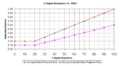
File:Plot impervious vs watershed inches.png [[Category:Level 3 - General information, reference, tables, images, and archives/Images/Graphs]](1,008 × 553 (97 KB)) - 20:52, 15 December 2022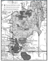
File:Tanners watershed and subwatershed areas.png [[Category:Level 3 - General information, reference, tables, images, and archives/Images/Maps]](822 × 1,024 (670 KB)) - 21:01, 15 December 2022


