![]()
Search results
Create the page "Tables" on this wiki! See also the search results found.
File:Minnesota ecoregion sections.jpg [[Category:Level 3 - General information, reference, tables, images, and archives/Images/Maps]](843 × 1,009 (81 KB)) - 01:53, 14 December 2022
File:Unit peak discharge Type 2 rainfall distribution.png [[Category:Level 3 - General information, reference, tables, images, and archives/Images/Graphs]](1,500 × 1,131 (314 KB)) - 20:55, 15 December 2022
File:Chloride concentrations in runoff.png [[Category:Level 3 - General information, reference, tables, images, and archives/Images/Graphs]](1,209 × 642 (71 KB)) - 17:47, 20 December 2022
File:Planting technique effect on height of Bosque elm.jpg [[Category:Level 3 - General information, reference, tables, images, and archives/Images/Graphs]](738 × 496 (29 KB)) - 20:51, 15 December 2022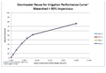
File:Stormwater reuse for irrigation performance curve – watershed 90 percent impervious.png [[Category:Level 3 - General information, reference, tables, images, and archives/Images/Graphs]](890 × 614 (38 KB)) - 20:55, 15 December 2022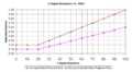
File:Plot impervious vs watershed inches.png [[Category:Level 3 - General information, reference, tables, images, and archives/Images/Graphs]](1,008 × 553 (97 KB)) - 20:52, 15 December 2022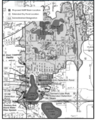
File:Tanners watershed and subwatershed areas.png [[Category:Level 3 - General information, reference, tables, images, and archives/Images/Maps]](822 × 1,024 (670 KB)) - 21:01, 15 December 2022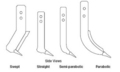
File:Agricultural shank designs.png [[Category:Level 3 - General information, reference, tables, images, and archives/Images/Schematics]](816 × 490 (54 KB)) - 02:26, 15 December 2022
File:MN soil suborders.jpg [[Category:Level 3 - General information, reference, tables, images, and archives/Images/Maps]](361 × 413 (84 KB)) - 15:16, 19 December 2022
File:Process and particle size.jpg [[Category:Level 3 - General information, reference, tables, images, and archives/Images/Schematics]](1,403 × 1,033 (209 KB)) - 02:45, 15 December 2022
File:Minnesota lakes, rivers and wetlands.jpg [[Category:Level 3 - General information, reference, tables, images, and archives/Images/Maps]](846 × 1,018 (115 KB)) - 01:54, 14 December 2022
File:St paul figure 2.png [[Category:Level 3 - General information, reference, tables, images, and archives/Images/Schematics]](956 × 708 (526 KB)) - 17:32, 15 December 2022
File:Minnesota's major watersheds.jpg [[Category:Level 3 - General information, reference, tables, images, and archives/Images/Maps]](910 × 852 (70 KB)) - 01:58, 14 December 2022
File:Statewide karst areas.jpg [[Category:Level 3 - General information, reference, tables, images, and archives/Images/Maps]](765 × 842 (61 KB)) - 02:00, 14 December 2022
File:Planting technique effect on trunk diameter of Bosque elm.jpg [[Category:Level 3 - General information, reference, tables, images, and archives/Images/Graphs]](729 × 468 (25 KB)) - 20:52, 15 December 2022
File:Stormwater reuse for irrigation performance curve – watershed 100 percent impervious.png [[Category:Level 3 - General information, reference, tables, images, and archives/Images/Graphs]](896 × 614 (38 KB)) - 20:54, 15 December 2022
File:Schematic of winged tip and conventional tip subsoiler.jpg [[Category:Level 3 - General information, reference, tables, images, and archives/Images/Schematics]](501 × 190 (18 KB)) - 14:24, 13 December 2022
File:Plot of construction and maintenance costs for wet basin.png [[Category:Level 3 - General information, reference, tables, images, and archives/Images/Graphs]](1,333 × 949 (168 KB)) - 20:52, 15 December 2022
File:Minnesota land cover.jpg [[Category:Level 3 - General information, reference, tables, images, and archives/Images/Maps]](843 × 999 (162 KB)) - 01:54, 14 December 2022
File:Minnesota groundwater sensitivity.png [[Category:Level 3 - General information, reference, tables, images, and archives/Images/Maps]](550 × 691 (586 KB)) - 18:19, 20 December 2022


