![]()
Search results
Create the page "Tables" on this wiki! See also the search results found.
File:Example particle retention curves.png [[Category:Level 3 - General information, reference, tables, images, and archives/Images/Graphs]](736 × 1,061 (293 KB)) - 20:41, 15 December 2022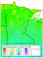
File:Minnesota ET.png [[Category:Level 3 - General information, reference, tables, images, and archives/Images/Maps]](568 × 769 (677 KB)) - 01:54, 14 December 2022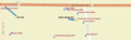
File:CVS Pharmacy.png [[Category:Level 3 - General information, reference, tables, images, and archives/Images/Schematics]](1,373 × 418 (211 KB)) - 17:58, 20 December 2022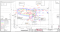
File:Example plume 4.png [[Category:Level 3 - General information, reference, tables, images, and archives/Images/Maps]](1,258 × 667 (434 KB)) - 18:16, 20 December 2022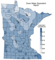
File:Snow water equivalent March.png [[Category:Level 3 - General information, reference, tables, images, and archives/Images/Maps]](845 × 926 (242 KB)) - 01:59, 14 December 2022
File:2012 impaired streams.jpg [[Category:Level 3 - General information, reference, tables, images, and archives/Images/Maps]](957 × 818 (257 KB)) - 01:48, 14 December 2022
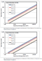
File:PSD curve.png [[Category:Level 3 - General information, reference, tables, images, and archives/Images/Graphs]](1,263 × 772 (365 KB)) - 17:43, 20 December 2022
File:Source water protection areas.jpg <noinclude>[[Category:Level 3 - General information, reference, tables, images, and archives/Images/Maps]]</noinclude>(772 × 863 (62 KB)) - 02:00, 14 December 2022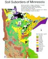
File:Minnesota dominant soil suborders.jpg [[Category:Level 3 - General information, reference, tables, images, and archives/Images/Maps]](608 × 752 (78 KB)) - 17:20, 20 December 2022
File:Green line.png [[Category:Level 3 - General information, reference, tables, images, and archives/Images/Schematics]](1,967 × 882 (1.8 MB)) - 17:57, 20 December 2022
File:Soil density.png [[Category:Level 3 - General information, reference, tables, images, and archives/Images/Graphs]](1,320 × 475 (187 KB)) - 17:43, 20 December 2022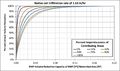
File:Infiltration rate 1.63 inch hr.jpg [[Category:Level 3 - General information, reference, tables, images, and archives/Images/Graphs]](975 × 579 (72 KB)) - 20:58, 15 December 2022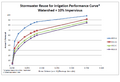
File:Stormwater reuse for irrigation performance curve – watershed 10 percent impervious.png [[Category:Level 3 - General information, reference, tables, images, and archives/Images/Graphs]](901 × 614 (44 KB)) - 20:54, 15 December 2022
File:Minnesota Anoka sand plain.jpg [[Category:Level 3 - General information, reference, tables, images, and archives/Images/Maps]](840 × 1,012 (64 KB)) - 01:50, 14 December 2022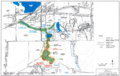
File:Brown's creek overview map.png [[Category:Level 3 - General information, reference, tables, images, and archives/Images/Maps]](1,287 × 810 (923 KB)) - 01:48, 14 December 2022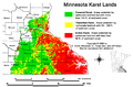
File:Minnesota karst lands.png [[Category:Level 3 - General information, reference, tables, images, and archives/Images/Maps]](1,403 × 927 (494 KB)) - 17:02, 20 December 2022
File:Filtration only facility.jpg [[Category:Level 3 - General information, reference, tables, images, and archives/Images/Schematic - bmps]](635 × 291 (128 KB)) - 14:20, 13 December 2022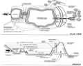
File:Plan and profile view of a wet pond.png [[Category:Level 3 - General information, reference, tables, images, and archives/Images/Schematic - bmps]](902 × 720 (244 KB)) - 18:00, 15 December 2022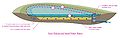
File:Iron enhanced sand filter basin schematic 1.jpg [[Category:Level 3 - General information, reference, tables, images, and archives/Images/Schematic - bmps]](1,430 × 454 (114 KB)) - 20:14, 15 August 2022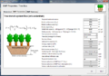
File:Bmp parameters tab tree box.png [[Category:Level 3 - General information, reference, tables, images, and archives/Images/Schematic - MIDs]](975 × 685 (305 KB)) - 12:23, 8 April 2023


