![]()
Search results
Create the page "Tables" on this wiki! See also the search results found.
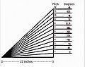
File:Comparison of roof slope expressed as roof pitch vs. roof slope in degrees.jpg [[Category:Level 3 - General information, reference, tables, images, and archives/Images/Graphs]](421 × 335 (21 KB)) - 20:40, 15 December 2022
File:Example plume 2.png [[Category:Level 3 - General information, reference, tables, images, and archives/Images/Maps]](1,282 × 678 (369 KB)) - 18:16, 20 December 2022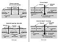
File:Spacing and depth of subsoilers.jpg [[Category:Level 3 - General information, reference, tables, images, and archives/Images/Schematics]](451 × 327 (25 KB)) - 14:24, 13 December 2022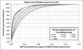
File:Infiltration rate 0.3 inch hr.jpg [[Category:Level 3 - General information, reference, tables, images, and archives/Images/Graphs]](975 × 581 (72 KB)) - 20:57, 15 December 2022
File:Minnesota major river basins.jpg [[Category:Level 3 - General information, reference, tables, images, and archives/Images/Maps]](839 × 1,013 (124 KB)) - 01:55, 14 December 2022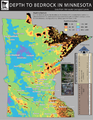
File:MN depth to bedrock.png [[Category:Level 3 - General information, reference, tables, images, and archives/Images/Maps]](816 × 1,056 (553 KB)) - 01:59, 14 December 2022
File:Open Arms.png [[Category:Level 3 - General information, reference, tables, images, and archives/Images/Schematics]](868 × 608 (343 KB)) - 17:57, 20 December 2022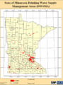
File:Minnesota DWSMAs.png [[Category:Level 3 - General information, reference, tables, images, and archives/Images/Maps]](684 × 926 (301 KB)) - 01:53, 14 December 2022
File:Minnetonka figure 2.jpg [[Category:Level 3 - General information, reference, tables, images, and archives/Images/Schematics]](975 × 549 (108 KB)) - 17:34, 15 December 2022
File:2012 impaired lakes non mercury.jpg [[Category:Level 3 - General information, reference, tables, images, and archives/Images/Maps]](957 × 818 (158 KB)) - 01:40, 14 December 2022
File:Rainfall distribution curves.png [[Category:Level 3 - General information, reference, tables, images, and archives/Images/Graphs]](574 × 398 (66 KB)) - 20:53, 15 December 2022
File:Snow depth at initiation of melt.jpg [[Category:Level 3 - General information, reference, tables, images, and archives/Images/Maps]](1,681 × 1,650 (982 KB)) - 01:59, 14 December 2022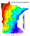
File:Minnesota normal annual precipitation.png [[Category:Level 3 - General information, reference, tables, images, and archives/Images/Maps]](397 × 480 (9 KB)) - 01:56, 14 December 2022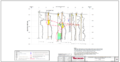
File:Example plume 3.png [[Category:Level 3 - General information, reference, tables, images, and archives/Images/Maps]](1,281 × 657 (318 KB)) - 18:16, 20 December 2022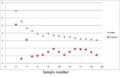
File:Permeameter samples.png [[Category:Level 3 - General information, reference, tables, images, and archives/Images/Graphs]](977 × 630 (37 KB)) - 17:43, 20 December 2022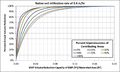
File:Infiltration rate 0.6 inch hr.jpg [[Category:Level 3 - General information, reference, tables, images, and archives/Images/Graphs]](975 × 581 (73 KB)) - 20:57, 15 December 2022
File:Filter strip design schematic 1.png [[Category:Level 3 - General information, reference, tables, images, and archives/Images/Schematic - bmps]](1,975 × 543 (130 KB)) - 17:27, 15 December 2022
File:BMP Summary tab bioretention with underdrain example.png [[Category:Level 3 - General information, reference, tables, images, and archives/Images/Schematic - MIDs]](975 × 687 (204 KB)) - 12:24, 8 April 2023
File:Filtration-stormevent.jpg [[Category:Level 3 - General information, reference, tables, images, and archives/Images/Schematic - bmps]](1,685 × 1,298 (1.49 MB)) - 14:20, 13 December 2022
File:Dry and wet swales.png [[Category:Level 3 - General information, reference, tables, images, and archives/Images/Swale photos]](973 × 325 (856 KB)) - 21:22, 15 December 2022


