Ramsey-Washington Metro Watershed District Living Streets Demonstration Project
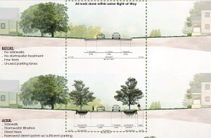
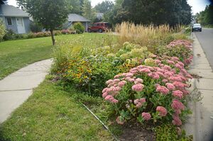
The “Living Streets” project was conceived as part of a larger effort to meet Ramsey-Washington Metro Watershed District’s (RWMWD) goals to reduce the amount of polluted runoff flowing into area lakes and the Mississippi River. The idea behind Living Streets stems from the concept of a street as more than simply a facility for driving and parking cars. In addition to providing typical functions like traffic conveyance, Living Streets improve neighborhood function by incorporating things like sidewalks and trees to shade hot pavement. They also address environmental needs by providing stormwater treatment and improving habitat corridors. When this design approach is applied holistically, neighborhoods are safer because traffic is calmed, pedestrians have dedicated travel routes, and residents have better opportunities for interaction. The neighborhood’s gardens and rows of trees create a pleasant and unified aesthetic, which not only provides visual value, but also reduces stormwater pollution, thereby improving the quality of nearby lakes and streams.
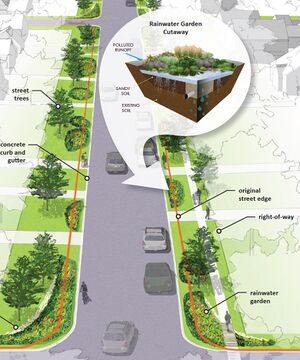
Unlike existing streets that are only designed for cars, living streets are designed for cars, people and the environment. Rainwater gardens and street trees remove pollutants from stormwater before the water enters area lakes, helping to improve lake quality. Narrower streets and trees also slow traffic, creating a safe environment for everyone. Bike trails and sidewalks make it easy for all residents to exercise and connect with neighbors. Living Streets will vary depending on the street function and location in the city. The Living Streets Plan includes design templates for three different types of streets (see residential concept illustration below) and concepts for busier collector streets. Living Streets are designed to balance safety and convenience for everyone using the street.
Elements of a Living Street may include:
- Sidewalks on one side
- Bike lanes (or wide paved shoulders)
- Parking
- Marked street crossings
- Pedestrian signals
- Comfortable and accessible transit stops
- Rainwater gardens
- Trees
- Vegetation
The Maplewood Living Streets project included the reconstruction of two miles of residential streets in the neighborhood east of McKnight Road and north of Minnehaha Avenue as part of the city’s planned Bartelmy-Meyer Street Improvement project.
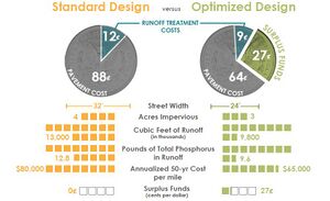
For this project, the streets were designed to be 24 feet wide rather than the typical 30 to 32-foot street width. The project included 32 rainwater gardens and one larger regional basin, 200 boulevard trees and 1.5 miles of sidewalk. Even with the addition of sidewalks, overall pavement was reduced by an acre.
Following project completion, 50 percent of the rainwater runoff is filtered or infiltrated, 40 percent evaporates and only 10 percent of the water runs directly into storm sewers.
Project Highlights:
- Public streets were narrowed from 32’ wide to 24’ and 1.5 miles of sidewalks were added, but overall pavement was reduced by 1 acre, resulting in improved function and livability for the neighborhood.
- System includes 32 rainwater gardens, 200 drought-tolerant trees and one regional filtration basin. Together they sequester 40 tons of CO2 per year.
- 50% of water in the street is filtered/ infiltrated, 10% of the water runs off, and 40% evaporates.
- Project completed in 2012. Operated and maintained by City of Maplewood.
- Total capital construction costs of $4,300,000, including all neighborhood street reconstruction costs. Funding sources included Clean Water Fund grant, District funds, City of Maplewood funds and assessments. Designed by Barr Engineering Company and Kimley-Horn and Associates, Inc.
- Multiple benefits—reduced construction and maintenance costs, safer traffic, reduced stormwater runoff and room for stormwater treatment, retains parking, accommodates pedestrian and bike travel, protects existing trees, shades pavement and improves urban forest, provides bird and butterfly habitat
This page was last edited on 5 December 2022, at 17:44.


