Difference between revisions of "Ecoregions"
(Created page with "This page contains the following maps: *Minnesota MPCA ecoregions *Minnesota ecoregion sections *Minnesota DNR ecoregion provinces {{alert|To view the title of an image hold ...") |
m |
||
| (14 intermediate revisions by the same user not shown) | |||
| Line 1: | Line 1: | ||
| − | This page contains the following | + | {{alert|This page contains the following map showing Minnesota's ecoregions:|alert-info}} |
| − | |||
| − | |||
| − | |||
| − | + | An ecoregion, is a geographical area where the land use (agriculture, forest, prairie, etc.), underlying geology, potential native plant community, and soils are relatively similar. [https://www.rmbel.info/resources/minnesota-ecoregions/ Link here for more information]. | |
| − | [[File:Minnesota | + | [[File:Minnesota Level III and IV Ecoregions.jpg|300px|thumb|alt=map showing ecoregions|<font size=3>Map showing Minnesota Level III and IV Ecoregions. For more information and access to shapefiles and a pdf version, click [http://www.epa.gov/wed/pages/ecoregions/mn_eco.htm#Please note: here]</font size>]] |
| − | [[ | + | |
| − | + | The map to the right replaced previous maps of Minnesota ecoregions. You can link to [[Archived maps|archived maps]]. The following maps have been archived. | |
| + | *Map showing MPCA's ecoregions | ||
| + | *Map showing Minnesota's ecoregions | ||
| + | *Map showing the DNR's ecoregion provinces | ||
| + | |||
| + | [[Category:Level 3 - General information, reference, tables, images, and archives/Images/Maps]] | ||
Latest revision as of 22:18, 19 December 2022
Information: This page contains the following map showing Minnesota's ecoregions:
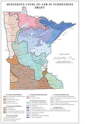
An ecoregion, is a geographical area where the land use (agriculture, forest, prairie, etc.), underlying geology, potential native plant community, and soils are relatively similar. Link here for more information.

Map showing Minnesota Level III and IV Ecoregions. For more information and access to shapefiles and a pdf version, click note: here
The map to the right replaced previous maps of Minnesota ecoregions. You can link to archived maps. The following maps have been archived.
- Map showing MPCA's ecoregions
- Map showing Minnesota's ecoregions
- Map showing the DNR's ecoregion provinces
This page was last edited on 19 December 2022, at 22:18.