![]()
Difference between revisions of "File:Example plume 1.png"
m |
m |
||
| Line 6: | Line 6: | ||
file:Example plume 3.png|alt=image of groundwater plume|North-south cross-section | file:Example plume 3.png|alt=image of groundwater plume|North-south cross-section | ||
</gallery> | </gallery> | ||
| + | |||
| + | [[Category:Level 3 - General information, reference, tables, images, and archives/Images/Case studies photos]] | ||
Latest revision as of 18:15, 20 December 2022
The red square identifies the location of the source, in this case, an underground storage tank. The blue shaded area illustrates the extent of contamination in shallow groundwater beneath the site. This simple image provides information about the horizontal extent of the plume, but does not provide detailed information, such as flow direction, the vertical extent of the plume, concentrations at different locations, and locations of wells that show or do not show contamination. Detailed illustrations, such as those shown below, can provide this information.
- Cross-sections illustrating the extent of the groundwater plume.
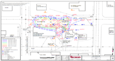
Plan view
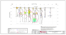
East-west cross-section
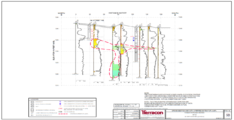
North-south cross-section


File history
Click on a date/time to view the file as it appeared at that time.
| Date/Time | Thumbnail | Dimensions | User | Comment | |
|---|---|---|---|---|---|
| current | 20:20, 7 March 2016 | 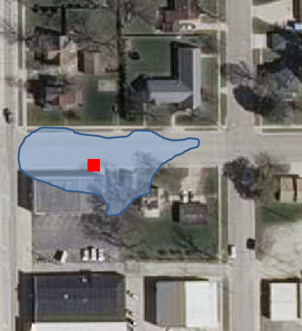 | 604 × 662 (688 KB) | Mtrojan (talk | contribs) |
You cannot overwrite this file.
File usage
The following page uses this file:
Metadata
This page was last edited on 20 December 2022, at 18:15.