![]()
File:Precipitation data retrieval.png

Original file (1,293 × 731 pixels, file size: 543 KB, MIME type: image/png)
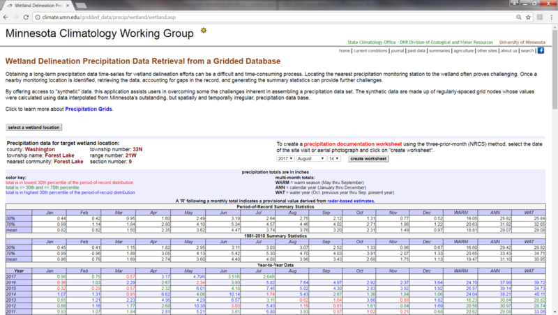
Example screen capture of a precipitation data retrieval from the Minnesota Climatology Working Group Gridded Database for a location near Forest Lake, MN. The gridded database is derived from a monthly precipitation database maintained by the State Climatology Office. To overcome the problems of data gaps across space and time, the State Climatology Office prepares monthly precipitation grids. Grids were prepared using the NWS data from 1891 to 1972. For the period 1973 to the present, Minnesota’s High Spatial Density Precipitation Network (HIDEN) data (which includes NWS data) are used. For each month of each year, monthly precipitation totals are estimated for grid nodes at regularly spaced (10 kilometers) intervals. The estimates are derived using an interpolation technique called "Kriging", which makes use of irregularly spaced precipitation data in the vicinity of the node to assign it a value. This way, all precipitation data provided by a volunteer observer, be it one month or one hundred months, are fully utilized in the creation of a data time-series. A precipitation total is calculated for every grid node, for every month without missing values. Once the grids are created, the calculation of long-term summary statistics such as normals and percentiles can be performed on each grid node.
File history
Click on a date/time to view the file as it appeared at that time.
| Date/Time | Thumbnail | Dimensions | User | Comment | |
|---|---|---|---|---|---|
| current | 18:49, 23 October 2017 | | 1,293 × 731 (543 KB) | Mtrojan (talk | contribs) |
You cannot overwrite this file.
File usage
The following page uses this file:
Metadata
This page was last edited on 23 October 2017, at 18:51.