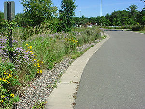
|
|
| Line 18: |
Line 18: |
| | *[[External resources for Infiltration trench ]] | | *[[External resources for Infiltration trench ]] |
| | *[[References for Infiltration trench]] | | *[[References for Infiltration trench]] |
| − |
| |
| − |
| |
| − | ===Design Criteria:===
| |
| − | *Contributing drainage area
| |
| − | *Underlying soil types
| |
| − | *Depth to the water table, bedrock or other impeding layer
| |
| − | *Proximity to buildings, drinking water supplies, [[Glossary#K|Karst]] features, etc.
| |
| − | *Source of stormwater [[Glossary#R|runoff]]
| |
| − |
| |
| − | ===Benefits===
| |
| − | *Reduces volume of stormwater [[Glossary#R|runoff]]
| |
| − | *Increases ground water [[Glossary#R|recharge]]
| |
| − | *Improves surface water quality
| |
| − | *Provides thermal benefits (e.g. to cold water fisheries)
| |
| − | *Mimics pre-development hydrology
| |
| − |
| |
| − | ===Limitations===
| |
| − | *Unusual construction considerations
| |
| − | *Potential for [[Glossary#G|ground water]] contamination
| |
| − | *Tendency to lose effectiveness over time due to clogging – if not properly constructed or maintained
| |
| − | *Not recommended for areas with steep slopes
| |
| − | *May require landscaping: consideration should be given to periods on inundation and drought
| |
| − |
| |
| − | ===Description===
| |
| − | <p>In general terms, [[Glossary#I|infiltration]] systems can be described as natural or constructed depressions located in permeable soils that capture, store and infiltrate stormwater runoff within 48 hours. These depressions can be located at the surface of the ground (e.g. infiltration basin) or they can be designed as underground facilities (e.g. structural chamber or excavated pit filled with aggregate such as an infiltration trench). Typically, infiltration systems are designed with one or more [[Glossary#P|pre-treatment]] facilities or they are designed as off-line facilities.</p>
| |
| − | {{alert|[[glossary#I|Infiltration]] systems should be located in permeable soils and a minimum 3-foot distance is ''REQUIRED'' from the bottom of the seasonally high water table, bedrock or other impeding layer per the [http://www.pca.state.mn.us/index.php/water/water-types-and-programs/stormwater/construction-stormwater/index.html Minnesota Pollution Control Agency Construction General Permit (CGP)]]|alert-danger}}
| |
| − |
| |
| − | <p>Dry wells and Trenches should be designed to handle the smaller, more frequent rainfall events. Stormwater associated with the larger rainfall events should bypass these practices by a separate pipe or an overflow device. Infiltration basins and underground infiltration systems should be designed to handle both the [[Glossary#W|water quality volume]] and as the water quantity volume.</p>
| |
| − | <p>Infiltration systems can be designed to address a number of stormwater management issues including: water quality, stormwater [[Glossary#G|runoff]] reduction, flow attenuation, [[Glossary#T|thermal impacts]] to cold water fisheries, and [[Glossary#G|groundwater]] [[Glossary#R|recharge]].</p>
| |
| − |
| |
| − | ===Maintenance Requirements===
| |
| − | *Establishment of native vegetation may require weeding, watering, pumping, replacement of plants and tree/shrub trimming
| |
| − | *Inspection and removal of [[Glossary#S|sediment]] accumulation
| |
| − | *Street sweeping of impervious areas adjacent to infiltration practices
| |
| − | *Avoid the application of fertilizer or herbicide in or near [[Glossary#I|infiltration]] practices
| |
| − |
| |
| − | ===SITE FACTORS===
| |
| − | [[file:Trench-storm.jpg|thumb|300px|alt=Schematic of Start of Storm Event - Initial runoff & storage|Schematic of Start of Storm Event - Initial runoff & storage]]
| |
| − | [[file:Trench-storage.jpg|thumb|300px|alt=Schematic of Duration of Storm Event - Storage & filtration/infiltration|Schematic of Duration of Storm Event - Storage & filtration/infiltration]]
| |
| − | [[file:Trench-infiltration.jpg|thumb|300px|alt=Schematic of inflitration trench following storm event - Remaining storage drawdown|Schematic of inflitration trench following storm event - Remaining storage drawdown]]
| |
| − |
| |
| − | *Max Drainage Areas: Dry Well/ Trench/ Basin = 1/ 5/ 50 Acres
| |
| − | *Max. Site Slope = 20 percent
| |
| − | *Min. Depth to Bedrock = 3 feet
| |
| − | *Min. Depth to Seasonally High Water Table = 3 feet
| |
| − | *NRCS Soil Type *C & D soils have limited infiltration ability but can be used to match predevelopment conditions = A,B,C*,& D
| |
| − | *Freeze/ Thaw Suitability = Poor - Good
| |
| − | *Potential [[Glossary#H|Hotspot]] [[Glossary#R|Runoff]] = NO
| |
| − |
| |
| − | ===MANAGEMENT SUITABILITY===
| |
| − | *Water Quality (V<sub>wq</sub>) = High
| |
| − | *Med. Channel Protection (V<sub>cp</sub>)
| |
| − | *[[Glossary#O|Overbank Flood Protection]] (Vp<sub>10</sub>) = Low/Med.
| |
| − | *[[Glossary#E|Extreme Flood]] Protection (Vp<sub>100</sub>) = Low
| |
| − | *[[Glossary#R|Recharge]] Volume (V<sub>re</sub>) = High
| |
| − |
| |
| − | ===MECHANISMS===
| |
| − | *Screening/ [[Glossary#F|Filtration]]
| |
| − | *Temperature Control
| |
| − | *Transpiration *if vegetated
| |
| − | *Soil [[Glossary#A|Adsorption]]
| |
| − | *Biological/ Micro. Uptake
| |
| − |
| |
| − | ===POLLUTION REMOVAL*===
| |
| − | *Total Suspended Solids [[Glossary#T|(TSS)]] = 100 percent
| |
| − | *Nutrients - [[Glossary#T|Total Phosphorus]]/ = 100 percent
| |
| − | *Total Nitrogen = 100 percent
| |
| − | *Metals - Cadmium, Copper, Lead, and Zinc = 100 percent
| |
| − | *Pathogens - Coliform, Streptococci, E. Coli = 100 percent
| |
| − | *Toxins - Hydrocarbon = 100 percent
| |
| − | <p>Pollution removal addresses only the impact on surface water, as there could be some transfer of pollution to the soil layer and [[Glossary#G|groundwater]].</p>
| |


