When infiltration is not authorized under a stormwater permit


Designed infiltration of stormwater is highly encouraged and generally preferred by regulatory agencies and stormwater practitioners. However, under certain conditions designed infiltration of stormwater presents an unacceptable risk to groundwater. Section 16 of the Construction Stormwater permit includes several prohibitions to infiltration of stormwater.
Infiltration is prohibited when the infiltration system will be constructed in
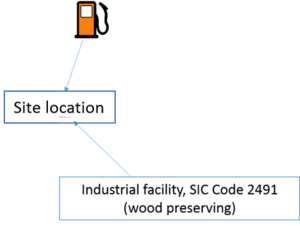
- areas that receive discharges from vehicle fueling and maintenance;
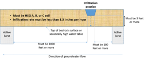
- areas with less than three (3) feet of separation distance from the bottom of the infiltration system to the elevation of the seasonally saturated soils or the top of bedrock;
- areas that receive discharges from industrial facilities which are not authorized to infiltrate industrial stormwater under an NPDES/SDS Industrial Stormwater Permit issued by the MPCA;
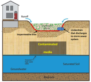
- areas where high levels of contaminants in soil or groundwater will be mobilized by the infiltrating stormwater;
- areas of predominately Hydrologic Soil Group D (clay) soils;
- areas within 1,000 feet up‐gradient, or 100 feet down‐gradient of active karst features;
- areas within a Drinking Water Supply Management Area (DWSMA) as defined in Minn. R. 4720.5100, subp. 13., if the system will be located:
- in an Emergency Response Area (ERA) within a DWSMA classified as having high or very high vulnerability as defined by the Minnesota Department of Health; or
- in an ERA within a DWSMA classified as moderate vulnerability unless a regulated MS4 Permittee performed or approved a higher level of engineering review sufficient to provide a functioning treatment system and to prevent adverse impacts to groundwater; or
- outside of an ERA within a DWSMA classified as having high or very high vulnerability, unless a regulated MS4 Permittee performed or approved a higher level of engineering review sufficient to provide a functioning treatment system and to prevent adverse impacts to groundwater; and
- areas where soil infiltration rates are more than 8.3 inches per hour unless soils are amended to slow the infiltration rate below 8.3 inches per hour.
Each of these is discussed in greater detail below.
Contents
- 1 Discharges from vehicle fueling areas
- 2 Shallow bedrock and shallow water table
- 3 Discharges from industrial facilities where infiltration is prohibited
- 4 Sites where high levels of contaminants may be mobilized
- 5 Areas with Hydrologic Soil Group D soils
- 6 Areas near active karst
- 7 Areas within a Drinking Water Supply Management Area
- 8 Areas in soils with very high infiltration rates
Discharges from vehicle fueling areas
Vehicle fueling areas represent a relatively high risk for spills involving highly mobile and toxic chemicals. Gasoline compounds in particular are mobile and contain chemicals that represent a significant risk to human health and the environment (e.g. benzene). Standard designs for infiltration practices will not be adequate to treat runoff with high concentrations of these chemicals and the chemicals will readily leach through the underlying soil, thus representing a risk to groundwater. For more information, see the section on potential stormwater hotspots.
Shallow bedrock and shallow water table
Stormwater infiltrating below an infiltration practice may require additional treatment even after passing through the media or soil in the infiltration practice. The distance needed to provide adequate treatment varies with soil and pollutants in the infiltrating water. For example, soils with high clay or organic matter contents typically retain pollutants better than sandy soils having little organic matter. A separation distance of 3 feet is commonly used for other types of infiltrating water, such as water infiltrating from a septic drain field. A separation distance of 5 feet is recommended, particularly in sandy soils, but a minimum of 3 feet separation from either bedrock or the seasonally high water table is required. For more information see the pages on shallow soils and depth to bedrock and shallow groundwater.
Discharges from industrial facilities where infiltration is prohibited
Infiltration is prohibited at certain industrial facilities where infiltration represents a potential risk for groundwater contamination. This prohibition exists for 5 Standard Industry Code (SIC) sectors.
- Sector A (SIC 2491) - wood preserving.
- Sector K - hazardous waste treatment, storage, or disposal facilities
- Sector M - automobile salvage yards
- Sector N - scrap waste materials
- Sector S - air transportation with deicing
Although the prohibition on infiltration at these sites does not apply to infiltration practices operating prior to April 5, 2010, the prohibition in the construction stormwater permit applies to all facilities operating under these 5 sectors. Infiltration is not allowed at any site receiving stormwater discharges from a facility operating within one of these 5 sectors. For more information, see the page on stormwater infiltration at permitted stormwater industrial sites.
Sites where high levels of contaminants may be mobilized

Infiltrating stormwater that passes through contaminated soils or comes into contact with contaminated groundwater has a high potential to mobilize those contaminants. In addition to representing a risk to human health and the environment, mobilizing contaminants creates legal liability risks for the owner and operator of the infiltration facility. It is difficult to define what high levels of contaminants are and it is often difficult to determine if infiltration will come into contact with contaminated soil or groundwater. An example of a site where infiltration is prohibited is shown on the right.
The manual contains guidance on infiltration at sites that are or may be contaminated, including a screening assessment for contamination at potential stormwater infiltration sites.
Areas with Hydrologic Soil Group D soils
D soils have very low infiltration rates (0.06 inches per hour in the manual). Over a 48 hour drawdown period, a soil with an infiltration rate of 0.06 inches per hour would only infiltrate 2.88 inches of water. Consequently, infiltration practices, such as bioinfiltration, permeable pavement with no underdrain, and infiltration basins are not feasible. Low infiltration rates result in extended surface ponding of water, which may damage vegetation, lead to mosquito breeding, damage soil structure, and reduce pollutant treatment by the BMP.
Areas near active karst
Active karst is defined as a terrain having distinctive landforms and hydrology created primarily from the dissolution of soluble rocks within 50 feet of the land surface [Minn. R. 7090]. A site with active karst has the greatest potential for development of a sinkhole below a BMP. Sinkholes can lead to catastrophic failure of a BMP. In addition, focused infiltration and recharge that results from collecting and infiltrating large amounts of stormwater at a discrete site can enhance sinkhole development. Infiltration practices must therefore be a minimum of 1000 feet upgradient or 100 feet downgradient of active karst. This diminishes the likelihood that the infiltration practice will contribute to sinkhole development. For more information, read the section on karst.
Areas within a Drinking Water Supply Management Area
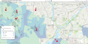
A Drinking Water Supply Management Area (DWSMA) is the surface and subsurface area surrounding a public water supply well, including the wellhead protection area, that must be managed by the entity identified in a wellhead protection plan. Because stormwater infiltrating through soil may reach groundwater and impact an aquifer containing a public supply well, infiltration is prohibited within a DWSMA under the following conditions:
- the DWSMA is classified as highly or very highly vulnerable and the proposed infiltration practice overlies the Emergency Response Area (ERA);
- the DWSMA is classified as highly or very highly vulnerable and the proposed infiltration practice does overlie within the ERA, unless a higher engineering review sufficiently provides a functioning treatment system that prevents adverse impacts to groundwater; or
- the DWSMA is classified as moderately vulnerable and overlies an ERA, unless a higher engineering review sufficiently provides a functioning treatment system that prevents adverse impacts to groundwater.
For more information see the section on stormwater and wellhead protection.
Areas in soils with very high infiltration rates
Soils with very high infiltration rates have limited ability to attenuate pollutants since water is moving rapidly through the soil. A value of greater than 8.3 inches per hour is used to identify soils where infiltration is prohibited. These will typically be well sorted medium- to coarse-sands and gravels. These soils typically have low concentrations of organic matter, which makes them further susceptible to pollutant leaching. These soils must be amended to slow the infiltration rate below 8.3 inches per hour.

