|
|
| (34 intermediate revisions by the same user not shown) |
| Line 1: |
Line 1: |
| − | {{alert|This page provides the following information on rainfall frequency distributions for Minnesota:|alert-info}} | + | {{alert|Precipitation frequency information (Atlas 14) has been updated by the National Oceanic and Atmospheric Administration (NOAA). We recommend using Atlas 14.|alert-info}} |
| − | *Rainfall frequency curves for the 1, 2, 5, 10, 25, 50, and 100 year 24-hour rainfall events for Minnesota. The source of the data is Technical Paper 40 ([http://www.nws.noaa.gov/oh/hdsc/PF_documents/TechnicalPaper_No40.pdf National Oceanic and Atmospheric Administration])
| |
| − | *Rainfall frequency and volume percentiles as a function of precipitation depth for ten locations in Minnesota. Rainfall frequency specifies the number of 24-hour rain events, expressed as a percent of all events, that are less than a certain depth. Volume represents the total annual volume of rain that is associated with a particular rain depth. For example, 88 percent of rain events in Cloquet are 1 inch or less, while rain events of one inch or less account for 60 percent of the annual volume.
| |
| | | | |
| − | {{alert|To view the title of an image hold the mouse over the image. To view the image click on the image. Most views show higher resolution depictions of the image.|alert-info}}
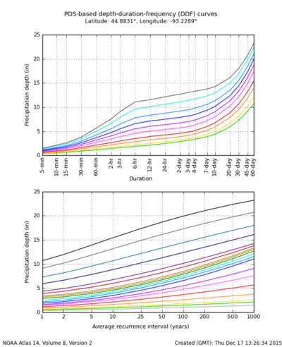
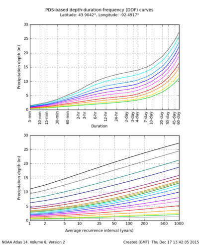
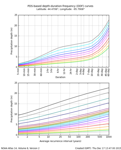
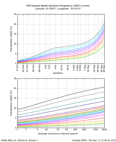
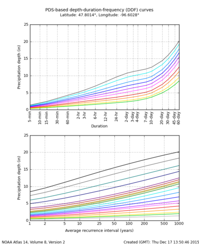
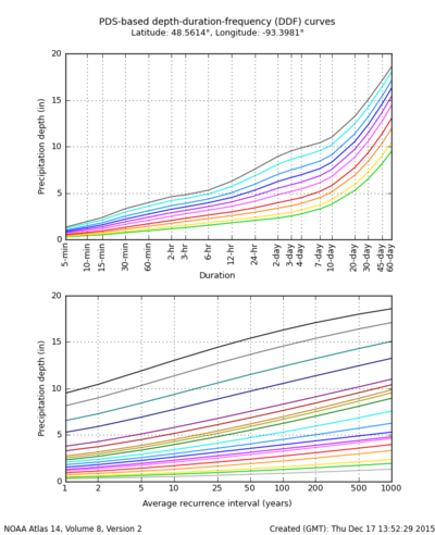
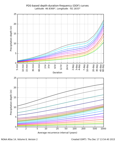
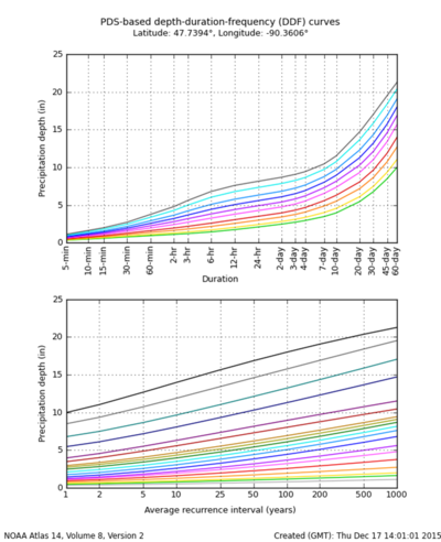
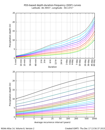
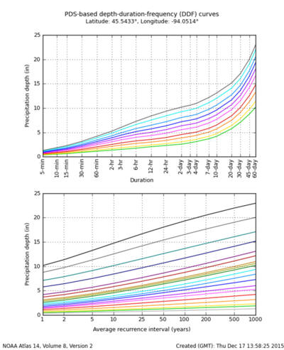
| + | NOAA's Atlas 14, Volume 8 precipitation frequency information can be found on [https://hdsc.nws.noaa.gov/hdsc/pfds/pfds_map_cont.html?bkmrk=mn NOAA's precipitation frequency data server]. Rainfall frequency maps from [https://www.weather.gov/gyx/TP40s.htm Technical Paper 40] have been moved to [[Technical Paper 40 rainfall frequency maps|this page]]. Although we recommend going to the NOAA site for rainfall information, we've provided rainfall frequency plots for several locations in Minnesota. To see a comparison of Atlas 14 and TP-40, [http://stormwater.pca.state.mn.us/index.php/File:Atlas_14_and_TP_40_comparison.png link here]. For additional information on Atlas 14 and comparisons with TP-40, see the following pages. |
| | + | *[http://www.ceam.org/vertical/Sites/%7BD96B0887-4D81-47D5-AA86-9D2FB8BC0796%7D/uploads/8SessionRainfallAtlas.pdf Rainfall Atlas 14: Replacement of Technical Paper 40] |
| | + | *[https://www.weather.gov/owp/hdsc_faqs Frequently Asked Questions about Atlas 14] |
| | | | |
| − | [[File:1 year 24 hour rainfall.jpg|300 px|alt=map showing 1-year 24-hour rainfall distribution across Minnesota|map showing 1-year 24-hour rainfall distribution across Minnesota]] | + | To see information on frequency-volume relationships, see [http://stormwater.pca.state.mn.us/index.php/Rainfall_volume-frequency_maps this page] or [http://stormwater.pca.state.mn.us/images/a/a8/Issue_paper_B_-_precipitation_frequency_analysis_and_use.pdf Issue Paper B]. |
| − | [[File:2 year 24 hour rainfall.jpg|300 px|alt=map showing 2-year 24-hour rainfall distribution across Minnesota|map showing 1-year 24-hour rainfall distribution across Minnesota]]
| + | |
| − | [[File:5 year 24 hour rainfall.jpg|300 px|alt=map showing 5-year 24-hour rainfall distribution across Minnesota|map showing 1-year 24-hour rainfall distribution across Minnesota]] | + | [[file:Atlas 14 MSP airport.png|400px|left|thumb|alt=MSP airport Atlas 14 graphs|<font size=3>'''Minneapolis-St. Paul International Airport'''</font size>]] |
| − | [[File:10 year 24 hour rainfall.jpg|300 px|alt=map showing 10-year 24-hour rainfall distribution across Minnesota|map showing 1-year 24-hour rainfall distribution across Minnesota]] | + | |
| − | [[File:25 year 24 hour rainfall.jpg|300 px|alt=map showing 25-year 24-hour rainfall distribution across Minnesota|map showing 1-year 24-hour rainfall distribution across Minnesota]] | + | [[file:Atlas 14 Rochester airport.png|400px|right|thumb|alt=Rochester airport Atlas 14 graphs|<font size=3>'''Rochester International Airport'''</font size>]] |
| − | [[File:50 year 24 hour rainfall.jpg|300 px|alt=map showing 50-year 24-hour rainfall distribution across Minnesota|map showing 1-year 24-hour rainfall distribution across Minnesota]] | + | |
| − | [[File:100 year 24 hour rainfall.jpg|300 px|alt=map showing 100-year 24-hour rainfall distribution across Minnesota|map showing 1-year 24-hour rainfall distribution across Minnesota]]
| + | [[file:Atlas 14 Marshall.png|400px|left|thumb|alt=Marshall Atlas 14 graphs|<font size=3>'''Marshall'''</font size>]] |
| − | [[File:Cloquet rainfall frequencies.png|500px|alt=map showing rainfall frequency and volume percentiles as a function of precipitation depth for Cloquet|Map showing rainfall frequency and volume percentiles as a function of precipitation depth for Cloquet]] | + | |
| − | [[File:Fargo rainfall frequencies.png|500px|alt=map showing rainfall frequency and volume percentiles as a function of precipitation depth for Fargo|Map showing rainfall frequency and volume percentiles as a function of precipitation depth for Fargo]] | + | [[file:Atlas 14 Morris.png|400px|right|thumb|alt=Morris Atlas 14 graphs|<font size=3>'''Morris'''</font size>]] |
| − | [[File:Grand Forks rainfall frequencies.png|500px|alt=map showing rainfall frequency and volume percentiles as a function of precipitation depth for Grand Forks|Map showing rainfall frequency and volume percentiles as a function of precipitation depth for Grand Forks]] | + | |
| − | [[File:Grand Marais rainfall frequencies.png|500px|alt=map showing rainfall frequency and volume percentiles as a function of precipitation depth for Grand Marais|Map showing rainfall frequency and volume percentiles as a function of precipitation depth for Grand Marais]] | + | [[file:Atlas 14 Crookston.png|400px|left|thumb|alt=Crookston Atlas 14 graphs|<font size=3>'''Crookston'''</font size>]] |
| − | [[File:Itasca rainfall frequencies.png|500px|alt=map showing rainfall frequency and volume percentiles as a function of precipitation depth for Itasca|Map showing rainfall frequency and volume percentiles as a function of precipitation depth for Itasca]] | + | |
| − | [[File:Lamberton rainfall frequencies.png|500px|alt=map showing rainfall frequency and volume percentiles as a function of precipitation depth for Lamberton|Map showing rainfall frequency and volume percentiles as a function of precipitation depth for Lamberton]]
| + | [[file:Atlas 14 International Falls.png|400px|right|thumb|alt=International Falls Atlas 14 graphs|<font size=3>'''International Falls'''</font size>]] |
| − | [[File:Minneapolis St. Paul rainfall frequencies.png|500px|alt=map showing rainfall frequency and volume percentiles as a function of precipitation depth for Minneapolis and St. Paul|Map showing rainfall frequency and volume percentiles as a function of precipitation depth for Minneapolis and St. Paul]] | + | |
| − | [[File:Rochester rainfall frequencies.png|500px|alt=map showing rainfall frequency and volume percentiles as a function of precipitation depth for Rochester|Map showing rainfall frequency and volume percentiles as a function of precipitation depth for Rochester]]
| + | [[file:Atlas 14 Duluth.png|400px|left|thumb|alt=Duluth Atlas 14 graphs|<font size=3>'''Duluth'''</font size>]] |
| − | [[File:St. Cloud rainfall frequencies.png|500px|alt=map showing rainfall frequency and volume percentiles as a function of precipitation depth for St. Cloud|Map showing rainfall frequency and volume percentiles as a function of precipitation depth for St. Cloud]]
| + | |
| − | [[File:Thief River Falls rainfall frequencies.png|500px|alt=map showing rainfall frequency and volume percentiles as a function of precipitation depth for Thief River Falls|Map showing rainfall frequency and volume percentiles as a function of precipitation depth for Thief River Falls]] | + | [[file:Atlas 14 Grand Marais.png|400px|right|thumb|alt=Grand Marais Atlas 14 graphs|<font size=3>'''Grand Marais'''</font size>]] |
| | + | |
| | + | [[file:Atlas 14 Brainerd.png|400px|left|thumb|alt=Brainerd Atlas 14 graphs|<font size=3>'''Brainerd'''</font size>]] |
| | + | |
| | + | [[file:Atlas 14 St Cloud.png|400px|right|thumb|alt=St. Cloud Atlas 14 graphs|<font size=3>'''St. Cloud'''</font size>]] |
| | + | |
| | + | <noinclude> |
| | + | [[Category:Level 3 - General information, reference, tables, images, and archives/Images/Maps]] |
| | + | </noinclude> |

