Difference between revisions of "High-gradient stormwater step-pool swale"
m |
m |
||
| Line 28: | Line 28: | ||
*[https://stormwater.pca.state.mn.us/index.php?title=Requirements,_recommendations_and_information_for_using_swale_with_an_underdrain_as_a_BMP_in_the_MIDS_calculator Requirements, recommendations and information for using dry swale (grass swale) with an underdrain in the MIDS calculator] | *[https://stormwater.pca.state.mn.us/index.php?title=Requirements,_recommendations_and_information_for_using_swale_with_an_underdrain_as_a_BMP_in_the_MIDS_calculator Requirements, recommendations and information for using dry swale (grass swale) with an underdrain in the MIDS calculator] | ||
*[[Requirements, recommendations and information for using swale side slope as a BMP in the MIDS calculator]] | *[[Requirements, recommendations and information for using swale side slope as a BMP in the MIDS calculator]] | ||
| + | |||
| + | <noinclude> | ||
| + | [[Category:swale]] | ||
| + | </noinclude> | ||
Revision as of 13:32, 21 May 2018
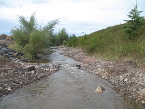
Stormwater step pools are defined by its design features that address higher energy flows due to more dramatic slopes than dry or wet swales. Using a series of pools, riffle grade control, native vegetation and a sand seepage filter bed, flow velocities are reduced, treated, and, where applicable, infiltrated. to shallow groundwater. The physical characteristics of the stormwater step pools are similar to Rosgen A or B stream classification types, where “bedform occurs as a step/pool, cascading channel which often stores large amounts of sediment in the pools associated with debris dams” (Rosgen, 1996). These structures feature surface/subsurface runoff storage seams and an energy dissipation design that is aimed at attenuating the flow to a desired level through energy and hydraulic power equivalency principles (Anne Arundel County, 2009). Stormwater step pools are designed with a wide variety of native plant species depending on the hydraulic conditions and expected post-flow soil moisture at any given point within the stormwater step pool.
High-gradient stormwater step-pool swale articles
- Terminology for high-gradient stormwater step-pool swale
- Overview for high-gradient stormwater step-pool swale
- Types of infiltration
- Types of filtration
- Design criteria for high-gradient stormwater step-pool swale
- Construction specifications for high-gradient stormwater step-pool swale
- Operation and maintenance of high-gradient stormwater step-pool swale
- Assessing the performance of high-gradient stormwater step-pool swale
- Check dams for stormwater swales
- Plants for swales
- Calculating credits for high-gradient stormwater step-pool swale
- Cost considerations
- External resources for high-gradient stormwater step-pool swale
- References for high-gradient stormwater step-pool swale
- High-gradient stormwater step-pool swale and interesting websites
Stormwater step pools are currently not included as a BMP in the MIDS calculator. The swale main channel BMP can be used, but the maximum allowable slope is 4 percent. To dtermine volume retention for slopes greater than 4 percent, you will need to develop a relationship between the slope and volume retained. To do this, determine volume retention at 0.5 percent slope increments for your site at slopes ranging from 0.5 to 4 percent. Determine the appropriate regression for volume retention and slope and calculate the volume retained at the slope for your site. The relationship is not linear. Links to MIDS calculator information are provided below.
- Requirements, recommendations and information for using dry swale (grass swale) without an underdrain in the MIDS calculator
- Requirements, recommendations and information for using dry swale (grass swale) with an underdrain in the MIDS calculator
- Requirements, recommendations and information for using swale side slope as a BMP in the MIDS calculator
