Difference between revisions of "Soil physical properties and processes"
m (→Soil color) |
m () |
||
| Line 1: | Line 1: | ||
= = | = = | ||
| − | + | Physical properties of soil include color, <span title="Soil texture (such as loam, sandy loam or clay) refers to the proportion of sand, silt and clay sized particles that make up the mineral fraction of the soil."> '''texture'''</span>, <span title="Soil structure describes the arrangement of the solid parts of the soil and of the pore space located between them. It is determined by how individual soil granules clump, bind together, and aggregate, resulting in the arrangement of soil pores between them."> '''structure'''</span>, <span title="Porosity or void fraction is a measure of the void (i.e. empty) spaces in a material, and is a fraction of the volume of voids over the total volume, between 0 and 1, or as a percentage between 0% and 100%."> '''porosity'''</span>, <span title="the weight of soil in a given volume"> [https://stormwater.pca.state.mn.us/index.php/Alleviating_compaction_from_construction_activities '''density''']</span>, consistence, and temperature. These properties affect processes such as infiltration, erosion, and biologic activity. These properties also affect suitability of soil for different uses, such as stormwater infiltration, subgrade for roads, and strength for building. | |
| − | + | This page provides an overview of soil physical properties, processes they affect, effects of human activities, and where appropriate, discussion of stormwater applications. | |
| − | |||
| − | This page provides an overview of soil physical properties, processes they affect, and | ||
==Soil texture== | ==Soil texture== | ||
| Line 10: | Line 8: | ||
[[File:Soil texture triangle.jpg|300px|thumb|alt=image of soil texture triangle]|<font size>Soil texture triangle showing the [https://en.wikipedia.org/wiki/United_States_Department_of_Agriculture USDA] classification system based on grain size. Click on image to enlarge.</font size>]] | [[File:Soil texture triangle.jpg|300px|thumb|alt=image of soil texture triangle]|<font size>Soil texture triangle showing the [https://en.wikipedia.org/wiki/United_States_Department_of_Agriculture USDA] classification system based on grain size. Click on image to enlarge.</font size>]] | ||
| − | Soil texture (such as loam, sandy loam or clay) refers to the proportion of sand, silt and clay sized particles that make up the mineral fraction of the soil. Soil texture is determined with one of the following methods. | + | Soil texture (such as loam, sandy loam or clay) refers to the proportion of <span title="Particles with a diameter of between 0.074 and 4.75 millimeters."> '''sand'''</span>, <span title="Fine-grained soil particles with a diameter between 0.002 mm and 0.06 mm."> '''silt'''</span> and <span title="Fine-grained soil particles with a particle diameter less than 0.002 mm"> '''clay'''</span> sized particles that make up the mineral fraction of the soil. Soil texture is determined with one of the following methods. |
*Mechanical sieving, if particle size > 0.05 mm | *Mechanical sieving, if particle size > 0.05 mm | ||
| − | *Sedimentation if size < 0.05 mm. Sedimentation measures the settling rate of particles in liquid medium and relates this rate to the particle mass by use of the [https://en.wikipedia.org/wiki/Stokes%27_law | + | *<span title="Sedimentation is the process by which solids are removed from the water column by settling. Sedimentation practices include dry ponds, wet ponds, wet vaults, and other devices."> [https://stormwater.pca.state.mn.us/index.php?title=Stormwater_sedimentation_Best_Management_Practices '''Sedimentation''']</span> if size < 0.05 mm. Sedimentation measures the settling rate of particles in liquid medium and relates this rate to the particle mass by use of the [https://en.wikipedia.org/wiki/Stokes%27_law <span title="The force required to move a sphere through a given viscous fluid at a low uniform velocity is directly proportional to the velocity and radius of the sphere."> '''Stoke's Law'''</span>]. Forces acting on soil particle are gravitation, buoyancy and drag forces, all of which depend on particle size. Larger particles settle first. The particle mass is determined by density and particle size. Soils must be dispersed prior to measurement. Two methods are commonly used. |
**Hydrometer method ([https://lter.kbs.msu.edu/protocols/108 see here for description]) | **Hydrometer method ([https://lter.kbs.msu.edu/protocols/108 see here for description]) | ||
**Pipette method ([https://www.youtube.com/watch?v=vmgFjL0GR5A see this video for a description]) | **Pipette method ([https://www.youtube.com/watch?v=vmgFjL0GR5A see this video for a description]) | ||
Revision as of 21:12, 16 June 2021
Contents
Physical properties of soil include color, texture, structure, porosity, density, consistence, and temperature. These properties affect processes such as infiltration, erosion, and biologic activity. These properties also affect suitability of soil for different uses, such as stormwater infiltration, subgrade for roads, and strength for building.
This page provides an overview of soil physical properties, processes they affect, effects of human activities, and where appropriate, discussion of stormwater applications.
Soil texture
![image of soil texture triangle]](/images/thumb/7/79/Soil_texture_triangle.jpg/300px-Soil_texture_triangle.jpg)
Soil texture (such as loam, sandy loam or clay) refers to the proportion of sand, silt and clay sized particles that make up the mineral fraction of the soil. Soil texture is determined with one of the following methods.
- Mechanical sieving, if particle size > 0.05 mm
- Sedimentation if size < 0.05 mm. Sedimentation measures the settling rate of particles in liquid medium and relates this rate to the particle mass by use of the Stoke's Law. Forces acting on soil particle are gravitation, buoyancy and drag forces, all of which depend on particle size. Larger particles settle first. The particle mass is determined by density and particle size. Soils must be dispersed prior to measurement. Two methods are commonly used.
- Hydrometer method (see here for description)
- Pipette method (see this video for a description)
Other methods are used to determine texture, but these employ qualitative approaches. They include the feel method, ball and ribbon methos, and ball throwing method. These are described here. These methods may be satisfactory for some applications, such as determining if a soil may be suitable for infiltration, but they must be conducted by an experienced person, such as a professional soil scientist.
The following particle size distribution, based on sieve analysis, is commonly used to define soil particles.
- gravel > 2 mm
- sand 0.05 - 2 mm
- very coarse 1 - 2 mm
- coarse 0.5 - 1 mm
- medium 0.25 - 0.5 mm
- fine 0.1 - 0.25 mm
- very fine 0.05 - 0.1 mm
- silt 0.002 - 0.05 mm
- clay < 0.002 mm (< 2 micrometer)
Soil texture describes the distribution of these different size particles in a soil. There are twelve soils based on the distribution of sand, silt and clay. The adjacent image displays the soil texture triangle, which assigns soil type based on the distribution of sand, silt, and clay.
Texture affects many soil processes, including infiltration, drainage (water and air distribution), erosion, chemical processes, and biologic processes. These are discussed generally below.
- Sand: limited structural development, rapid infiltration, rapid drainage, low water holding capacity, leaching of minerals and organic material, reduced chemical and biological processing compared to soils with high clay content
- Silt: poor structural development, moderate infiltration rates, well drained, moderate rates of chemical and biological processing, easily eroded and compacted
- Clay: slow infiltration rates, poorly drained, high water holding capacity, high rates of chemical processing when not compacted or saturated, easily compacted
- Loam: since these are a mixture of sand, silt, and clay, these soils are generally well drained, have good water holding capacity, are chemically and biologically diverse and active
Soil structure
This page provides a nice overview and discussion of soil structure.
Soil structure describes the arrangement and organization of soil particles in the soil, and the tendency of individual soil particles to bind together in aggregates. Aggregation affects water and air transport, which affects the movement of solutes and pollutants and affects biologic activity, including plant growth.
Structure development is influenced by
- the amount and type of clay, as well as the exchangeable ions on the clay;
- the amount and type of organic matter, which provides food for soil fungi and bacteria and their secretion of cementing agents (polysaccharides)
- the presence of cementing agents such as iron and aluminum oxides; and
- vegetation, which produces organic matter and binds soil particles together through rooting.
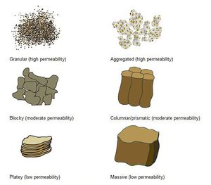
Soil structure is typically divided into one of the following groups, as illustrated in the adjacent image.
- Granular – roughly spherical, like grape nuts. Usually 1-10 mm in diameter. Most common in A horizons, where plant roots, microorganisms, and sticky products of organic matter decomposition bind soil grains into granular aggregates
- Aggregated - this structural type is often not included in classifications, but represents a soil where some granular components have aggregated, but not to the extent found in prismatic or columnar structures.
- Platy – flat peds that lie horizontally in the soil. Platy structure can be found in A, B and C horizons. It commonly occurs in an A horizon as the result of compaction.
- Blocky – roughly cube-shaped, with more or less flat surfaces. If edges and corners remain sharp, we call it angular blocky. If they are rounded, we call it subangular blocky. Sizes commonly range from 5-50 mm across. Blocky structures are typical of B horizons, especially those with a high clay content. They form by repeated expansion and contraction of clay minerals.
- Prismatic – larger, vertically elongated blocks, often with five sides. Sizes are commonly 10-100mm across. Prismatic structures commonly occur in fragipans.
- Columnar – the units are similar to prisms and are bounded by flat or slightly rounded vertical faces. The tops of columns, in contrast to those of prisms, are very distinct and normally rounded.
Soil structure affects water and air movement in soil and is therefore important to soil biota. Platy and massive soils have restricted air and water movement, while granular and aggregated soils have enhanced air and water transport.
Soil structure can be altered by human activity, including the following.
- Compaction, which leads to platy and blocky structure
- Cultivation, which breaks up aggregates in the plow layer but can compact deeper layers
- Removal of vegetation, which reduces aggregation
- Excessive moving and handling of soil, which can destroy aggregates or lead to compaction
- Excessive sodium, often through irrigation, which disperses soil and breaks down structure
Soil density
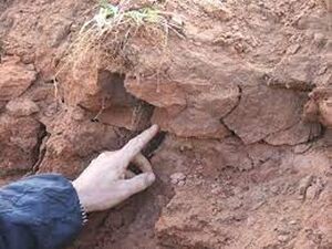
Soil density is related to the mineral and organic composition of a soil and to soil structure. The standard measure of soil density is bulk density, defined as the proportion of the weight of a soil relative to its volume. It is expressed as a unit of weight per volume, and is commonly measured in units of grams per cubic centimeters (g/cm3). Bulk density is an indicator of the amount of pore space available within individual soil horizons, as it is inversely proportional to pore space:
Pore space = 1 – bulk density/particle density
where particle density is the weight/volume of the solid material. Typical particle densities are 2.65 g/cm3 for minerals and 1.3 g/cm3 for organic matter.
For example, at a bulk density of 1.60 g/cm3, pore space equals 0.40 or 40%. At a bulk density of 1.06 g/cm3, pore space equals 0.60 or 60%.
Because of the lower particle density of organic matter compared to minerals, soils with higher concentrations of organic matter have lower bulk densities. Typical bulk densities of different soils are illustrated in the adjacent table.
Comparison of bulk densities for undisturbed soils and common urban conditions. (Source: Schueler, T. 2000. The Compaction of Urban Soils: Technical Note #107 from Watershed Protection Techniques. 3(2): 661-665. Center for Watershed Protection, Ellicott City, MD.)
For information on alleviating soil compaction, see Alleviating compaction from construction activities
Link to this table
| Undisturbed soil type or urban condition | Surface bulk density (grams / cubic centimeter |
|---|---|
| Peat | 0.2 to 0.3 |
| Compost | 1.0 |
| Sandy soil | 1.1 to 1.3 |
| Silty sands | 1.4 |
| Silt | 1.3 to 1.4 |
| Silt loams | 1.2 to 1.5 |
| Organic silts / clays | 1.0 to 1.2 |
| Glacial till | 1.6 to 2.0 |
| Urban lawns | 1.5 to 1.9 |
| Crushed rock parking lot | 1.5 to 2.0 |
| Urban fill soils | 1.8 to 2.0 |
| Athletic fields | 1.8 to 2.0 |
| Rights of way and building pads (85% compaction) | 1.5 to 1.8 |
| Rights of way and building pads (95% compaction) | 1.6 to 2.1 |
| Concrete pavement | 2.2 |
| Quartzite (rock) | 2.65 |
Bulk density affects water and air transport in soils. Soils with high densities resist water and air transport. Soils with high density may also impede root growth.
Several human activities affect bulk density. Soils at construction sites are generally compacted as a result of excavation, mixing, stockpiling, equipment storage, and equipment traffic. In addition, exposed subsoil is susceptible to compaction. Clay soils and wet soils are more susceptible to compaction. Even at sites where selective grading is employed, compaction occurs as a result of construction equipment, stockpiling and vehicle traffic (Randrup, 1998; Lichter and Lindsay, 1994).
When soil is compacted, porosity decreases and bulk density increases. Typical increases in bulk density are shown in the adjacent table, with other compacting activities included for comparison. As a result, permeability of air and water in soil decreases, soil water-holding capacity is reduced, and root growth is impeded. On a watershed scale, soil compaction leads to increased runoff and erosion.
Increase in soil bulk density as a result of different land uses or activities.
Link to this table
| Land use or activity | Increase in bulk density (grams / cubic centimeter | Source (link to Reference list) |
|---|---|---|
| Grazing | 0.12 to 0.20 | Smith, 1999 |
| Crops | 0.25 to 0.35 | Smith, 1999 |
| Construction, mass grading | 0.34 to 0.35 | Randrup, 1998; Lichter and Lindsey, 1994 |
| Construction, no grading | 0.20 | Lichter and Lindsey, 1994 |
| Construction traffic | 0.17 to 0.40 | Lichter and Lindsey, 1994; Smith, 1999; Friedman, 1998 |
| Athletic fields | 0.38 to 0.54 | Smith, 1999 |
| Urban lawn and turf | 0.30 to 0.40 | Various sources |
The effects of compaction are difficult to overcome and may persist for decades. Natural processes such as freeze-thaw cycles, animal burrowing, and root growth only slowly diminish compaction. These natural processes are typically limited to the upper foot or two of soil. Even when bulk densities decrease, the original soil structure may not be achieved (Randrup, 1997; Schueler and Holland, 2000).
The following table summarizes results for different activities designed to alleviate compaction. The results suggest compost amendment is an effective method for alleviating compaction, while tillage is considerably less effective. Note however, this is an area of on-going research and some recent studies suggest properly conducted tillage can be effective at reducing compaction. For an example, link here.
Reported Activities that Restore or Decrease Soil Bulk Density
Link to this table
| Land use or activity | Decrease in bulk density (gms/cc) | Source |
|---|---|---|
| Tilling of soil | 0.00 to 0.02 | Randrup, 1918. Patterson and Bates, 1994 |
| Spedialized soil loosening | 0.05 to 0.15 | Rolf, 1998 |
| Selective grading | 0.00 | Randrup, 1998 and Lichter and Linsy, 1994 |
| Soil amendments | 0.17 | Patterson and Bates, 1994 |
| Compost amendments | 0.25 to 0.35 | Kolsti et al. 1995 |
| Time | 0.20 | Legg et al, 1996 |
| Reforestration | 0.25 to 0.35 | Article 36 |
Soil porosity
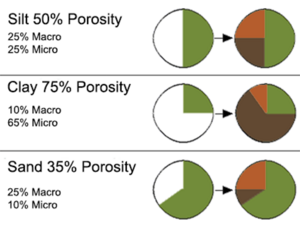
Pore space is that part of the bulk volume of soil that is not occupied by either mineral or organic matter but is open space occupied by either gases or water. As discussed above, soil porosity is inversely related to bulk density. In a productive, medium-textured soil the total pore space is typically about 50% of the soil volume.
Although porosity is related to density, pore size is an important factor affecting soil processes. Soils with similar porosity may have different distributions of pore sizes. The smallest pores (<0.1 μm diameter) hold water too tightly for use by plant roots. Plant-available water is held in pores 0.1–75 μm in diameter. Macropores (>75 μm diameter) are generally air-filled when the soil is at field capacity, but they can rapidly transport water and solutes to deeper depths in the soil profile. Clay soils have smaller pores, but more total pore space than sands. Soils with extensive biologic activity have greater macroporosity (e.g. plant roots, animal burrows).
The pore size distribution affects the ability of plants and other organisms to access water and oxygen; large, continuous pores allow rapid transmission of air, water and dissolved nutrients through soil, and small pores store water between rainfall or irrigation events. Pore size variation also promotes biologic activity by compartmentalizing pore space, which reduces competition between organisms, including microbes.
The same human activities affecting soil structure and density affect porosity. Porosity can be enhanced in compacted soils by addition of organic material and through tillage. Macroporosity can be promoted with deeper rooting vegetation.
Soil consistence (plasticity)
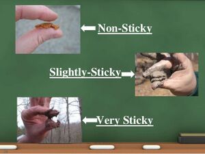
Soil consistence refers to the ease with which an individual ped can be crushed by the fingers. Soil consistence, and its description, depends on soil moisture content. Terms commonly used to describe consistence include the following.
- loose – noncoherent when dry or moist; does not hold together in a mass
- friable – when moist, crushed easily under gentle pressure between thumb and forefinger and can be pressed together into a lump
- firm – when moist crushed under moderate pressure between thumb and forefinger, but resistance is distinctly noticeable Wet soil
- plastic – when wet, readily deformed by moderate pressure but can be pressed into a lump; will form a “wire” when rolled between thumb and forefinger sticky – when wet, adheres to other material and tends to stretch somewhat and pull apart rather than to pull free from other material
- soft – when dry, breaks into powder or individual grains under very slight pressure
- hard – when dry, moderately resistant to pressure; can be broken with difficulty between thumb and forefinger
Soil consistency is useful in estimating the ability of soil to support structures, such as buildings and roads. The measurement is not widely used for stormwater applications.
Soil temperature
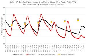
Soil temperature is affected by climate, water content of a soil, soil color, soil cover (e.g. presence or absence of mulch), depth in the soil profile, and air and water flow within a soil. Minnesota soils are generally slow to warm in spring due to climate, but the following conditions affect temperature.
- Dark colored soils warm more quickly and attain higher temperatures than light colored soils
- Organic matter imparts a darker color to soil, leading to increased warming, but also retains water, which can slow warming
- Soils with high porosity and well connected pores will warm faster and cool quicker
- Soils on south facing slopes are subject to greater thermal inputs compared to north facing soils
- Soil temperatures fluctuate less with depth in the soil profile
- Soil temperatures fluctuate daily
Soil temperatures are an important consideration in vegetated systems. Human activities that affect temperature include the following.
- Adding organic matter and mulch will slow warming but also increase heat retention
- Activities that improve soil structure, reduce compaction, and increase pore connectivity increase heat transfer
- Vegetation can result in shading
- Light colored soil coverings reflect solar radiation and decrease heating
Soil color
Soil color is largely determined by the organic matter content, drainage conditions, degree of oxidation, and in some cases, presence of specific minerals. Soil color is not a widely used factor in stormwater applications.
Recommended links
- Food and Agricultural Organization
- University of Nevada, Reno
- University of California, Davis
- USDA-NRCS
- Wikipedia
- What is Soil Structure and Why is it Important? - Deeproot
- RHS Gardening
- Soil temperature resources - University of Nebraska, Lincoln
