Stormwater infiltration and setback (separation) distances
This site was recently updated and is undergoing review. Please submit comments to Mike Trojan at the MPCA. Anticipated completion date is August, 2015.
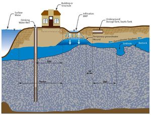
Separation distance is defined as the distance from the closest point of a BMP to the particular feature being considered. Recommended and REQUIRED separation distances for infiltration BMPs, shown in the figure to the right, are discussed below. Specific information on separation distances can be found on pages for individual BMPs. Note that all REQUIRED statements in this section refer to requirements contained in the NPDES/SDS Construction Stormwater (CSW) General Permit (CGP).
Contents
Vertical setback distances
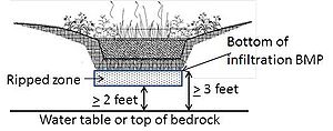
Vertical separation distance is the vertical distance from the bottom of a BMP to the top of the feature of concern. The shortest vertical distance is used in measuring the separation distance.
Seasonally Saturated Soils
Under the CGP, a three (3) foot vertical separation is REQUIRED between the bottom of any infiltration BMP and the top of seasonally saturated soils. Seasonally saturated soil is defined as the highest seasonal elevation in the soil that is evidenced by the presence of redoximorphic features or other parameters as assessed by a soils specialist. The temporary groundwater mound that develops below an operational infiltration BMP is not required to be a minimum of 3 feet below the bottom of the infiltration BMP. However, it is HIGHLY RECOMMENDED that this mound not penetrate into the infiltration BMP which could inhibit the pollutant removal within the media contained in the BMP. The base of the BMP may be raised to achieve the 3 foot separation.
Bedrock
Under the CGP a minimum 3 foot vertical separation is REQUIRED between the base of any constructed infiltration BMP and the top of the bedrock. The base of the BMP may be raised to achieve the 3 foot separation distance
Karst Bedrock
Karst topography is a geological formation shaped by the dissolution of a layer, or layers, of soluble bedrock. Groundwater in karst regions is particularly vulnerable to contamination. There is also concern about the formation of sinkholes resulting from focused infiltration. The CGP prohibits infiltration within areas that are 1,000 feet up gradient or 100 feet down gradient of an identified karst feature, unless approved by a local government with an approved Municipal Separate Storm Sewer System (MS4) NPDES permit. In addition, the 3 foot minimum separation to bedrock is applicable under the CGP. Additional detail on identifying and testing for Karst is detailed here.
Horizontal Separation Distances
Horizontal separation distance is the horizontal distance from the closest point of a BMP to the feature of concern. The shortest horizontal distance is used in determining the separation.
Drinking Water Wells
A 100 foot horizontal separation is REQUIRED between any infiltration BMP and drinking water well. This is to ensure there is adequate removal of pollutants before the infiltrating water reaches the drinking water well. The CGP prohibits infiltration in areas within a Drinking Water Supply Management Area (DWSMA) as defined in Minn. R. 4720.5100, subp. 13., unless approved by a local unit of government that has a current NPDES MS4 permit. Maps of DWSMA areas are available through the MN Department of Health.
Building or Other Structural Foundations
A horizontal separation of 10 feet is HIGHLY RECOMMENDED between any infiltration BMP and a structural foundation. Despite this recommended separation distance, the designer is encouraged to model the groundwater flow in the area using an unsaturated flow model to ensure that the infiltration BMP will not impact any surrounding structural foundations. Additional modeling is critical if the site contains a fill material which may result in a greater separation distance related to the greater void space often present in fill material which allows the infiltrating water to migrate laterally to the building foundation.
Surface Waters
Infiltration BMPs are not recommended if the infiltrating water contains a soluble pollutant that is likely to be transported via groundwater to a surface water impaired for that pollutant (e.g. chloride). There may also be local zoning or shoreline restrictions. Prior to the designing of any infiltration BMP that may impact surface waters, the user should consult the local city or county zoning office and watershed management organization, or the Soil and Water Conservation District.
Septic System Tank/Leach Field
A 35 foot horizontal separation is recommended between any infiltration BMP and a septic tank or leach field.
Potential Contamination Sources
The CGP PROHIBITS infiltration when the infiltration system will be constructed in areas where high levels of contaminants in the soil or groundwater will be mobilized by the infiltrating water. At all other sites not regulated by the CGP, infiltration is not generally recommended in areas of contaminated soils for the same reason that the infiltrating water may mobilize the contamination. Stormwater infiltration may be feasible, however, on sites where the infiltration BMP can be isolated from the contaminants.
It is HIGHLY RECOMMENDED that stormwater infiltration BMPs not be installed in areas with contaminated groundwater down-gradient of the BMP, unless barriers or other devices that maintain a separation between the water infiltrating from the BMP and the contaminants are present. More information regarding stormwater management in contaminated areas can be found here.
Site Topography and Slopes
Unless slope stability analyses demonstrate otherwise, it is HIGHLY RECOMMENDED that infiltration practices be located a minimum horizontal distance of 200 feet up-gradient from the toe of a slope that is greater than 20 percent, and that the slopes in contributing drainage areas be limited to 15 percent. Guidance for managing infiltration and runoff to minimize the likelihood of slope erosion and slumping can be found at the Toronto and Region Conservation website and The University of Wisconsin Sea Grant Institute website.
Methods for Determining Separation Distances
Horizontal separation distances can be determined using simple measurement devices such as a GPS, survey, or even something as basic as a tape measure or measuring wheel. Distances should be measured from the edge of the BMP to the edge of the area of interest.
Vertical separation distances require subsurface investigations. Information on determining the vertical distance to bedrock or groundwater can be found here.
Related pages
- Overview
- Pre-treatment considerations for stormwater infiltration
- BMPs
- Pollutant fate and transport in stormwater infiltration systems
- Surface water and groundwater quality impacts from stormwater infiltration
- Groundwater mounding
- Karst
- Shallow soils and shallow depth to bedrock
- Shallow groundwater
- Soils with low infiltration capacity
- Potential stormwater hotspots
- Wellhead protection
- Contaminated soils and groundwater
- Decision tools
- Research needs
- References for stormwater infiltration

