TCMA Chloride TMDL - TMDL Development
Contents
TMDL Development
This section presents the methodology used to develop the TCMA chloride TMDLs and the resulting load capacity and various components of the TMDL, including load allocations (LA), wasteload allocations (WLA), MOS, seasonal variation, and future growth/reserve capacity.
Chloride TMDL Methodology
The TMDLs were developed for each of the lakes, wetlands and streams in the TCMA impaired by chloride. A TMDL quantifies the allowable pollutant loading to a lake or stream that will result in water quality standards being attained. The WQT for the TMDLs was set to the chronic water quality criterion for chloride of 230 mg/L. The total allowable load, or the TMDL, is allocated to the various sources contributing chloride as well as a MOS and, in general, a RC. The TMDL equation can be written as:
- TMDL = WLA + LA + MOS + RC
Where:
- WLA = wasteload allocation for permitted sources, including MS4s and treatment facilities
- LA = load allocation for natural background and other non-permitted sources (mainly, runoff from rural and non-permitted areas)
- MOS = margin of safety
- RC = reserve capacity
Several approaches were considered for developing the TMDLs. A simple 0-dimensional, steady-state modeling approached was selected through consultation with the Technical Advisory Committee for calculating the allowable load from runoff, including the permitted MS4 areas and non-permitted areas. This approach assumes that chloride from winter maintenance activities and all other sources eventually makes its way to surface waterbodies through runoff. This approach was chosen for the following reasons: 1) chloride is a conservative substance and is in the dissolved phase in the water environment; therefore, complex fate and transport assessments are not needed; 2) determining the time for a system to respond to reduced chloride loads was not necessary to inform the TMDL or the CMP; and 3) the large number of lakes and streams needing a TMDL and the limited data available for a significant portion of them prohibited a more complex approach. This approach assumes eventual complete flushing in an impaired waterbody over the long-term.
The WQT for the waterbodies included in this TMDL is Minnesota’s chronic water quality standard for chloride, 230 mg/L. On this basis, the TMDL components were calculated as described below, with additional discussion following later in this section. It should be noted that the “WLA for MS4 areas” and “LA for runoff from non-permitted areas” are exclusive and do not overlap.
- Total allowable runoff load = runoff volumeTOTAL x WQT
- Margin of Safety (MOS) = 10% of the total allowable runoff load (both MS4 and non-permitted areas)
- = 10% x runoff volume x WQT
- LA for natural background sources (LABG) = runoff volumeTOTAL x natural background concentration
- WLA for MS4 areas (WLAMS4) = runoff volumeMS4 x WQT - LABG - MOS
- WLA for WWTPs (WLAWWTP) = WWTP design flow x WQT
- LA for runoff from non-permitted areas (LAnon-permitted )= runoff volumenon-permitted x WQT - LABG - MOS
- Reserve Capacity (RC) = set to zero for this TMDL
In light of the above, the Metro Area chloride TMDL is more explicitly expressed as below:
- TMDL = WLAMS4 + WLAWWTP + LAnon-permitted + LABG + MOS
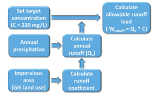
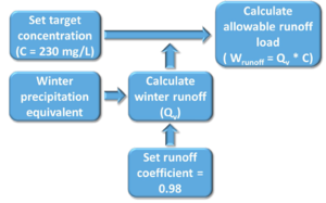
A simple schematic of the modeling approach for lakes and wetlands is shown in Figure 8 and for streams in Figure 9. The primary differences between the approaches for lakes and streams was that annual runoff was considered for lakes because of the longer retention times in lakes and subsequent mixing, whereas only winter-season runoff was considered for streams. Since the winter-season runoff was considered for the streams, the runoff coefficients were set to 0.98 to account for frozen ground conditions based on best professional judgment. The basic premise of this approach is to constrain runoff from having greater than 230 mg/L of chloride on average throughout the year in an impaired lake, and throughout the winter and spring snow melt season in an impaired stream. To express the TMDLs on an average daily basis, the annual lake and seasonal stream allowable loadings are divided by 365 days per year and by 151 days per winter season (November-March), respectively (see below).
Modeling approach – Lakes and Wetlands
The 0-dimensional modeling approach for lakes and wetlands takes into account the total tributary watershed area, percentage of impervious surface within the watershed area, and average annual precipitation. Based on these variables, an average annual runoff was calculated using the Simple Method (Schueler, 1987). The allowable runoff load was then calculated by multiplying the average annual runoff by the chronic water quality standard for chloride (230 mg/L).
Runoff coefficient
- 𝑅𝑣=0.05+0.9×𝐼𝐼𝑎𝑎
- Where: Ia = impervious fraction
- Rv = runoff coefficient
Average annual runoff
- 𝑅v = 𝑃 × 𝑃𝑗 × 𝑅𝑣
- Where: P = Annual rainfall (inches/yr) (30.6 inches/year for the TCMA)
- Pj = Fraction of annual rainfall events that produce runoff (usually 0.9)
- Rv = runoff coefficient
- R = Average annual runoff (inches)
Average annual runoff volume
- 𝑄𝑣 = 𝐴 × 𝑅 / 12
- Where: R = Annual runoff (inches/yr)
- A = total tributary watershed area (acres)
- Qv = average annual runoff volume (ac-ft/yr)
Allowable Annual Runoff Load (L, lbs/year)
- 𝐿 = 𝑄𝑣 × 𝐶 × 2.72
- Where: Qv = average annual runoff volume (ac-ft/yr)
- C = chronic water quality standard (230 mg/L)
- 2.72 = conversion factor
Modeling approach - Streams
A slightly modified approach was taken for the streams. The streams tend to exhibit the highest chloride concentrations during the spring snowmelt, which is then flushed through the system. The approach was modified to account for frozen ground conditions and seasonal runoff volume. The runoff coefficient was adjusted to 0.98 over the entire tributary watershed area to account for frozen ground conditions. The seasonal runoff volume is considered to be the total precipitation equivalent for the period from November 1 through March 31 (season is 151 days per year). This period is typically when salt is being applied and is expected to accumulate and run off during the spring snowmelt (as well as occasional winter melts). A seasonal precipitation equivalent for the period of November 1 through

