Event mean concentrations of total suspended solids in stormwater runoff
This page is under review
| Land use | Recommended emc TSS (mg/L) |
| Commercial | 75 |
| Industrial | 93 |
| Residential | 73 |
| Freeways/transportation | 87 |
| Mixed | 76 or calculate |
| Open space | 21 |
| Conventional roof | < 20 |
| |
This page provides information on event mean concentrations of total suspended solids (TSS) in urban stormwater runoff. For a discussion of TSS in stormwater runoff, including information on sources, fate, and water quality impacts, see Total Suspended Solids (TSS) in stormwater.
Contents
- 1 Objective
- 2 Methodology
- 3 Recommended event mean concentrations for total suspended solids
- 4 Factors affecting total suspended solid emcs in stormwater runoff
- 5 Adjusting event mean concentrations
- 6 Effect of emc on pollutant loading
- 7 Accounting for differences in pollutant loading
- 8 Example using the Minimal Impact Design Standards (MIDS) Calculator
- 9 References
Objective
Event mean concentrations (emcs) are used in models for predicting water quality impacts from stormwater runoff and stormwater treatment practices or pollution prevention practices. Pollutant loads, which are typically used to assess water quality impacts, including establishing total maximum daily loads (TMDLs), are a function of pollutant concentration and volume of runoff. It is therefore important to accurately determine appropriate event mean concentrations when assessing water quality impacts from stormwater runoff.
This page provides summary information that can be used for selecting or calculating appropriate emcs for total suspended solids.
Methodology
We conducted a review of literature to develop the EMCs shown on this page. Nearly all studies provided summary information; we therefore did not analyze raw data with the exception of data from Capitol Region Watershed District (see discussion below) and the National Stormwater Quality Database. We compiled the summary information into a spreadsheet and conducted simple statistical analysis of the information.
Data from the following studies were used to generate emcs for total suspended solids.
- National Stormwater Quality Database. This dataset provides data from several nationwide studies. We used only data from region 1, which includes Minnesota and states with similar rainfall patterns. Data were compiled for four land uses: Commercial (n=165), industrial (n=84), residential, (n=249), and open space (n=6).
- Lin (Review of Published Export Coefficient and Event Mean Concentration (EMCs) Data. This report includes summaries of multiple studies conducted in North America. Data existed for all land uses included in the table presenting recommended emcs.
- Washington District Department of the Environment - Selection of Event Mean Concentrations (EMCs). This study summarized data from studies in the Washington D.C. area. Land uses included commercial, roadway/highway, industrial, forest/open, and residential.
- U.S. Environmental Protection Agency, 1983, Results of the Nationwide Urban Runoff Program—Executive summary. Land uses included commercial and residential.
- Urban Stormwater Quality, Event-Mean Concentrations, and Estimates of Stormwater Pollutant Loads, Dallas-Fort Worth Area, Texas, 1992–93. Included commercial (n=42), residential (n=77), industrial (n=63) land uses.
- A review of sediment and nutrient concentration data from Australia for use in catchment water quality models . A compilation of multiple studies from Australia. Included forest (n=68) and mixed (n=36) land uses.
- Characterization of Urban Runoff Pollution between Dissolved and Particulate Phases . Study of five sites in China. Land uses included roof and transportation (roads).
- Quality Of Wisconsin Stormwater, 1989-94. Samples from mixed land use in Wisconsin (n=204).
- Analysis of Nonpoint Source Pollution Runoff from Urban Land Uses in South Korea. 23 samples in Korea from high density residential, medium desntiy residential, industrial, institutional land uses.
- Seasonal Performance Variations for Storm-Water Management Systems in Cold Climate Conditions. 15 samples from transportation land use in New Hampshire.
- Determination of event mean concentrations and first flush criteria in urban runoff. 31 samples from transportation land use in Los Angeles.
- Multiple linear regression models of urban runoff pollutant load and event mean concentration considering rainfall variables. 45 samples from commercial, industrial, and high density land uses.
- Stormwater runoff driven phosphorus transport in an urban residential catchment: Implications for protecting water quality in urban watersheds. 29 events from low density land use in Florida.
- Sources of phosphorus and street dirt from Two Urban Residential Basins in Madison, Wisconsin, 1994-95. 25 samples from medium density land use in Wisconsin.
- Nutrient Sources in Urban Areas – A Literature Review. Report summarizing multiple studies in Colorado. Land uses include residential, mixed, commercial, and open space.
- Contribution of surface runoff from forested areas to the chemistry of a through-flow lake. Forested land use in Poland.
- Brezonik and Stadelman, (2002). Analysis and predictive models of stormwater runoff volumes, loads, and pollutant concentrations from watersheds in the Twin Cities metropolitan area, Minnesota, USA.
In addition to the above sources, we compiled water quality monitoring data from 10 storm sewer outfalls in the Capitol Region Watershed in Minnesota. The data period for each outlet varied but generally spanned the period from about 2005 to 2019. The following information was compiled for each monitoring location.
- Date
- Total suspended solids in mg/L.
- Sample type, which included runoff samples during precipitation events, snowmelt samples, and baseflow samples for those locations where groundwater contributed to flow.
We also downloaded the 2015 National Stormwater Quality Database. The dataset includes information from across the U.S. We selected only data from Region 1, which includes Minnesota, for analysis. Four land uses included commercial, industrial, residential, and open space, with the number of samples for each land use varying.
For both of these data sets, we conducted simple statistical analyses.
Recommended event mean concentrations for total suspended solids
Emcs for TSS vary by land use. This section provides recommended emcs for different land uses. A discussion of factors affecting emcs and potential adjustments to emcs are provided in separate sections below.
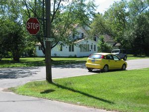
Residential land use
Studies from the literature frequently provide concentrations for residential land use or occasionally for different types of residential land use, typically low-, medium-, or high-density residential. Most studies do not define criteria for dividing residential land use into these subcategories. Various definitions can be found in the literature, including the following.
- Residential: "Residential land use means any real property or portion thereof which is used for housing human beings. This term includes property used for schools, day care centers, nursing homes, or other residential-style facilities or recreational areas." (Law Insider accessed December 31, 2019).
- High-density residential: More than 10 units per acre; can include multiple-occupant dwellings
- Medium-density residential: 1-10 dwellings per acre; can include multiple-occupant dwellings
- Low-density residential: one dwelling per 1-5 acres; can include multiple-occupant dwellings
Note that residential land uses can include other land uses, such as commercial and industrial. Many studies therefore classify land uses as mixed or urban, even though a specific land use may dominate a particular area.
Because of the variable and arbitrary manner in which residential land use is classified, we provide a single recommended value for event mean concentrations in residential land uses. We provide additional discussion below so that users can adjust this recommended value depending on local conditions. We used the following references for generating a recommended value for residential land use.
- Wisconsin; 10 sites; n=25; median=46
- Korea; 6 sites; n=23; median=63.3
- LA; 2 sites; 4 samples; median = 91.2
- NURP median = 101
- Dallas median = 78
- China median = 68
- NSQD 250 sites; median = 92 (region 1)
- Line = 42
We chose these studies because they contained large amounts of data and they were located in humid and sub-humid areas of the U.S. The median of the above 7 values is 73 mg/L.
Commercial land use
"Commercial land use is the use of land for commercial purposes including building offices, shops, resorts and restaurants as opposed to construction of a residential house" (Reference, accessed December 24, 2019). Commercial areas considered in this analysis do not include areas used for commercial crop production.
We used the following studies in our analysis. Commercial
- NSQD; n=164; median = 97.15
- NURP median = 69
- Dallas median = 42
- L.A.; n=5; mean = 49.6
- China Median = 81
- Harper = 87.7
The median concentration from these studies is 75 mg/L.
Industrial land use
We used the following studies in our analysis.
- NSWD; n=84; median=70
- Dallas median = 104
- Korea median = 78.8; 6 sites
- LA median = 92.2; 6 sites
- Harper = 93.3
- Line = 170
The median TSS concentration from these studies is 93 mg/L. TSS concentrations do not appear to vary much across different industrial land uses, with the primary sources likely being road salt and atmospheric deposition. However, the following may contribute to higher TSS loads in industrial areas.
- Cleaning and washing operations
- Heavy vehicle traffic
- Specific industries such as food processing plants, meat packing plants and lockers, metal finishing facilities, and industries that generate or handle animal waste (including human sources)
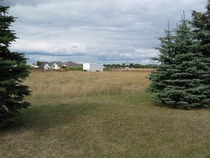
Open space
Open space consists of land that is undeveloped. Typically it will not contain buildings or other built structures. Many open spaces are accessible to the public. Open space generally consists of green space (land that is partly or completely covered with grass, trees, shrubs, or other vegetation). Abandoned parcels lacking structures may be considered open space, but it is generally more accurate to include these areas in the land use that existed prior to the parcel being vacant, or including it in adjacent land use categories. The following references were used to generate a recommended value a TSS emc for open space.
- NSQD; n=6; median = 20.5
- NURP median = 70
- Harper = 11.1
Parks and recreation areas are generally included in open space.
Transportation corridors, highways, and freeways
This land use includes major transportation corridors where the land use is exclusively transportation. These areas are typically highly impervious and may include only small vegetated areas consisting of swales or medians, and relatively small right-of-way areas. This land use does not include arterial streets in residential, commercial, and industrial areas. The following references were used to generate a recommended value a TSS emc for open space.
- China median=86.72
- Fort Worth median =90; n=27
- New Hampshite median = 55.54; n=27
- LA median = 87.54; n=39
- Harper = 50.3
The median value from these studies is 87 mg/L.
TSS concentrations from transportation corridors are highly variable depending on inputs. The primary inputs include road salt, sediment, and vehicle-related wastes, including oil. The recommended value should be adjusted based on vehicle traffic and likely suspended solids sources and inputs.
Roofs
Mixed land use
- DC median = 47.25; 4 sites
- Australia; n=49; median=105
- Korea median = 153.3
- Korea median =76; n=45
- WI median = 188; 2 sites
- NURP median=67
- Capitol Region Watershed District (9 outfalls) median = 97 mg/L
- Sullen median = 54.5
- L.A. median = 65.1
Overall median = 76 mg/L
An emc can be calculated if the total area of interest (Atotal), the area of each land use in the area of interest, and the emc for each land use in the area of interest are known.
Site emc = Σ1n ((AArea 1 * emcArea 1)/ (Atotal) + ... ((AArea n * emcArea n) / (Atotal)
where A = area in acres.
Example calculation
- 10 acres of residential; emc = mg/L
- 10 acres of commercial; emc = mg/L
- 10 acres of industrial' emc = mg/L
- 1 acre of transportation; emc = mg/L
Overall emc = (73 * 10/31) + (75 * 10/31) + (93 * 10/31) + (1 * 10/31) = 80.5 mg/L
NOTE: To calculate loads for a mixed land use, a curve number or runoff coefficient must be calculated based on the impervious surface for each of the land uses.
Summary table for event mean concentrations by land use
Event mean concentrations for total suspended solids.
Link to this table
| Land cover/land use | Range (mg/L) | Recommended value (mg/L) | Notes |
|---|---|---|---|
| Commercial | 42-164 | 75 | If applicable to models being used, adjust curve numbers/runoff coefficients when calculating loads |
| Industrial | 70-170 | 93 |
|
| Residential | 42-101 | 73 | |
| High-density/Multi-family residential | Calculate |
|
|
| Medium density residential | Calculate |
|
|
| Low density residential | Calculate |
|
|
| Freeways/transportation | 50-90 | 87 | |
| Mixed | 47-188 | 76 or calculate |
|
| Parks and recreation | Use value for open space or calculate |
|
|
| Open space | 11-70 | 21 | |
| Conventional roof | <20 | ||
| Institutional | 17-140 | 80 | |
| Forest/shrub/grassland | 26-140 | 72 | Sediment concentrations from forested areas vary widely with factors such as slope and forest condition. Concentrations may be very high, but the annual volume of runoff is typically much less than non-forested areas. |
| Open water and wetlands | see Notes (next column) |
|
|
| Cropland (row crops) | 50-160 | Literature review was not adequate to recommend an emc | |
| Pasture | 75-150 | 84 | Concentrations are a function of intensity of use. |
Factors affecting total suspended solid emcs in stormwater runoff
Concentrations of TSS show considerable variability within land uses. Using data from Region 1 of the National Stormwater Quality Database, mean concentrations are 50% greater than median concentrations for commercial, industrial, and residential land uses, indicating data are skewed toward higher concentrations. The mean for open space was only 7% greater than the median, indicating more uniform TSS concentrations.
Several factors affect concentrations of total suspended solids in stormwater runoff. The following bullet list summarizes some of the most important factors. Note these are general conclusions and not applicable to all local situations.
- Rainfall intensity and depth, including the maximum intensity and timing of this maximum. Most studies show emcs increase with rainfall intensity and depth during the initial period of runoff, but at some intensity emcs begin to decline due to dilution (Gong et al., 2016; Acharya and Piechota, 2010). Other studies show little or no effect of rain intensity (Schiff et al., 2016). During the latter part of a runoff event, TSS emcs and rain intensity are inversely related (Schiff et al., 2016).
- Interval between runoff events. As the number of days between runoff events increases, pollutants build up on impervious surfaces, resulting in greater TSS loading when runoff does occur. The effect on emcs is less certain and appears to vary with climate. This effect appears to be smaller in humid and sub-humid climates compared to arid and semi-arid climates (Gong et al., 2016; Acharya and Piechota, 2010; Li et. al, 2015).
- Length of runoff event. Typically, pollutant concentrations decrease after an initial peak associated with first flush. Studies suggest that, for runoff events lasting roughly 40 minutes or more, depending on intensity, TSS concentrations reach a relatively stable or slowly decreasing concentration that is 25-50% of the peak concentration (Li et. al, 2015; Schiff et al., 2016; Stenstrom and Kayhanian, 2005).
- Nature of watershed contributing to runoff and impervious connectedness. This effect relates to the phenomenon of first flush in which the greatest pollutant loading occurs in the early stages of runoff (Gong et al., 2016; Acharya and Piechota, 2010).
- First flush is more pronounced in smaller watersheds.
- First flush is more pronounced when the length of time between runoff events increases.
- First flush is less pronounced when there is greater directly connected impervious surface, since runoff can reach a specific discharge point from greater distances.
- First flush is more pronounced with higher rainfall intensities in the early part of a runoff event.
- First flush is less pronounced when there is treatment up in a watershed, including pretreatment
- Land use. Data on this page illustrates differences in TSS emcs between land uses. Several factors affect concentrations within a specific land use.
- Emcs increase in areas with extensive lawns on compacted soils and where lawns are directly adjacent to impervious surfaces.
- Emcs increase in areas with greater loading of organic debris, such as leaves and yard clippings. This is associated with seasonal effects.
- Emcs increase in areas with heavy vehicle traffic. Vehicle debris may be an important component of TSS in these areas.
- Emcs will be elevated in areas receiving winter applications of sand and deicers.
- Construction activity within the watershed. Extensive construction activity can increase emcs during the construction period, particularly in watersheds with well-connected impervious surface. Construction activity (e.g. individual residences) not covered an NPDES permit will contribute more sediment on a per area basis due to less stringent or no erosion protection or sediment control practices.
Adjusting event mean concentrations
Several factors affect emcs, as discussed above. Emcs can and should be adjusted when supporting data exist. Local monitoring data should be used to support different emcs than those recommended on this page, but the following guidelines may be used to adjust emcs.
- In areas where sand and/or deicers are applied, adjust emcs upward if calculating pollutant loads for winter and early spring.
- In areas with extensive tree canopy, adjust emcs upward if calculating pollutant loads for fall.
- Adjust emcs upward if there is extensive construction activity occurring during the period when pollutant loads are calculated.
- Adjust emcs as appropriate if certain management activities, such as street sweeping, are implemented.
Effect of emc on pollutant loading
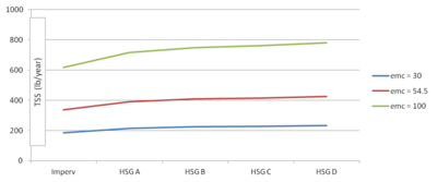
To assess the effect of changing the TSS emc, we ran several scenarios using the Minimal Impact Design Standards Calculator. For each model run we assumed 31.9 inches of precipitation annually. We varied the emc as follows
- 30 mg/L
- 54.5 mg/L (MIDS Calculator default)
- 100 mg/L
We varied land use as follows
- 1 acre of impervious
- 1 acre of impervious and 1 acre of turf on hydrologic group soil (HSG) A soil
- 1 acre of impervious and 1 acre of turf on B soil
- 1 acre of impervious and 1 acre of turf on C soil
- 1 acre of impervious and 1 acre of turf on D soil
The results, illustrated in the adjacent graph, indicate a small effect of soil. Changing the emc within a specific land use scenario, however, results in significant changes in loading. The change in loading is linear and equal to the following.
- impervious: 6.18 lbs/acre/yr increase in TSS load for each 1 mg/L increase in TSS
- A soil: 7.16 lbs/acre/yr increase in TSS load for each 1 mg/L increase in TSS
- B soil: 7.48 lbs/acre/yr increase in TSS load for each 1 mg/L increase in TSS
- C soil: 7.61 lbs/acre/yr increase in TSS load for each 1 mg/L increase in TSS
- D soil: 7.81 lbs/acre/yr increase in TSS load for each 1 mg/L increase in TSS
This exercise illustrates the importance of selecting an appropriate emc.
Accounting for differences in pollutant loading
Pollutant loads are a function of pollutant concentrations in runoff and the volume of runoff. Consequently, when calculating pollutant loads it is necessary to adjust both the emcs and volume of runoff. Volumes are typically calculated using curve numbers or runoff coefficients. The MPCA Simple Estimator, for example, employs a default runoff coefficient of 0.8 for commercial areas, compared to 0.44 for residential areas. The tables below may be used to determine the proper curve number or runoff coefficient. Percent impervious can be converted to a curve number using the following formula.
Curvenumber=(Impervious∗98)+((1−impervious)∗(openspacecurvenumberingoodconditionforthespecificsoil))
where impervious is given as a fraction (not a percent).
For example, if an area on B soils is 50 percent impervious, the curve number is given as (0.5 * 98) + ((1 - 0.50)(61)) = 79.5.
Curve numbers for urban and agricultural areas. Source: [USDA Urban Hydrology for Small Watersheds - TR-55. USDA Urban Hydrology for Small Watersheds - TR-55].
Link to this table
| Cover type and hydrologic condition | Soil Group A | Soil Group B | Soil Group C | Soil Group D |
|---|---|---|---|---|
| Open space poor condition (<50% cover) | 68 | 79 | 86 | 89 |
| Open space average condition (50-75% cover) | 49 | 69 | 79 | 84 |
| Open space good condition (>75% cover) | 39 | 61 | 74 | 80 |
| Impervious surfaces | 98 | 98 | 98 | 98 |
| Commercial (85% impervious) | 89 | 92 | 94 | 95 |
| Industrial (72% impervious) | 81 | 88 | 91 | 93 |
| Residential (65% impervious) | 77 | 85 | 90 | 92 |
| Residential (30% impervious) | 57 | 72 | 81 | 86 |
| Residential (12% impervious) | 46 | 65 | 77 | 82 |
| Pervious, no vegetation (newly graded) | 77 | 86 | 91 | 94 |
| Fallow with residue cover | 74-76 | 83-85 | 88-90 | 90-93 |
| Row crop, no residue | 67-72 | 78-81 | 85-88 | 89-91 |
| Row crop with residue | 64-71 | 75-80 | 82-87 | 85-90 |
| Pasture, good condition | 39 | 61 | 74 | 80 |
| Pasture, poor condition | 68 | 79 | 86 | 89 |
| Meadow | 30 | 58 | 71 | 78 |
| Woods, good condition | 32 | 58 | 72 | 79 |
| Woods, poor condition | 57 | 73 | 82 | 86 |
Runoff coefficients for different soil groups and slopes. Coefficients are for recurrence intervals less than 25 years. Source: Hydrologic Analysis and Design (4th Edition) (McCuen, 2017).
Link to this table
| Land use | Soil Group A | Soil Group B | Soil Group C | Soil Group D | ||||||||
|---|---|---|---|---|---|---|---|---|---|---|---|---|
| 0-2% | 2-6% | >6% | 0-2% | 2-6% | >6% | 0-2% | 2-6% | >6% | 0-2% | 2-6% | >6% | |
| Residential (65% impervious) | 0.25 | 0.28 | 0.31 | 0.27 | 0.30 | 0.35 | 0.30 | 0.33 | 0.38 | 0.33 | 0.36 | 0.42 |
| Residential (30% impervious) | 0.19 | 0.23 | 0.26 | 0.22 | 0.26 | 0.30 | 0.25 | 0.29 | 0.34 | 0.28 | 0.32 | 0.39 |
| Residential (12% impervious) | 0.14 | 0.19 | 0.22 | 0.17 | 0.21 | 0.26 | 0.20 | 0.25 | 0.31 | 0.24 | 0.29 | 0.35 |
| Commercial | 0.71 | 0.71 | 0.72 | 0.71 | 0.72 | 0.72 | 0.72 | 0.72 | 0.72 | 0.72 | 0.72 | 0.72 |
| Industrial | 0.67 | 0.68 | 0.68 | 0.68 | 0.68 | 0.69 | 0.68 | 0.69 | 0.69 | 0.69 | 0.69 | 0.70 |
| Streets | 0.70 | 0.71 | 0.72 | 0.71 | 0.72 | 0.74 | 0.72 | 0.73 | 0.76 | 0.73 | 0.75 | 0.78 |
| Parking | 0.85 | 0.86 | 0.87 | 0.85 | 0.86 | 0.87 | 0.85 | 0.86 | 0.87 | 0.85 | 0.86 | 0.87 |
| Open space | 0.05 | 0.10 | 0.14 | 0.08 | 0.13 | 0.19 | 0.12 | 0.17 | 0.24 | 0.16 | 0.21 | 0.28 |
| Cultivated land | 0.08 | 0.13 | 0.16 | 0.11 | 0.15 | 0.21 | 0.14 | 0.19 | 0.26 | 0.18 | 0.23 | 0.31 |
| Pasture | 0.12 | 0.20 | 0.30 | 0.18 | 0.28 | 0.37 | 0.24 | 0.34 | 0.44 | 0.30 | 0.40 | 0.50 |
| Meadow | 0.10 | 0.16 | 0.25 | 0.14 | 0.22 | 0.30 | 0.20 | 0.28 | 0.36 | 0.24 | 0.30 | 0.40 |
| Forest | 0.05 | 0.08 | 0.11 | 0.08 | 0.11 | 0.14 | 0.10 | 0.13 | 0.16 | 0.12 | 0.16 | 0.20 |
There are numerous studies summarizing TSS exports for different land uses. Examples include the following.
- Shaver et al. (2007) reported export rates of 1000 lb/ac/yr for commercial, 670 lb/ac/yr for industrial, 420 lb/ac/yr for high-density residential, 250 lb/ac/yr for medium density residential, and 65 lb/ac/yr for low density residential land use.
- Using the data from the National Stormwater Quality Database, median TSS export is 242 lb/ac/yr for commercial, 193 lb/ac/yr for industrial, 76 lb/ac/yr for residential, and 35 lb/ac/yr for open space.
- Baldys et al. (1998) reported TSS export of 4430 lbs/mi2/yr for industrial land uses, compared to 2000 lb/mi2 for commercial land use and 1440 lb/mi2/yr for residential land use in the Dallas-Fort Worth area
The studies illustrate the importance of estimating runoff volume, since loading from commercial areas, for example, is greater than from residential areas even though the emc for commercial areas is lower (0.20 mg/L compared to 0.325 mg/L for residential).
Example using the Minimal Impact Design Standards (MIDS) Calculator
| Example MIDS Calculator with and without adjusted emcs | ||||||
| Land use | % impervious | Impervious acres | Pervious acres | emc (mg/L) | Total TSS load (lb/yr) | TSS export (lb/ac/yr) |
| Residential (>40% canopy) | 30 | 0.90 | 2.1 | 80 | 663.8 | 221.3 |
| Residential (<10% canopy) | 30 | 0.6 | 1.4 | 70 | 387.2 | 193.6 |
| Commercial | 85 | 0.85 | 0.15 | 75 | 408.8 | 408.8 |
| Industrial | 72 | 0.72 | 0.28 | 93 | 447.8 | 447.8 |
| Open space | 10 | 0.10 | 0.90 | 21 | 37.6 | 37.6 |
| Total suspended solids load with adjusted emcs = 1945.2 pounds/yr | ||||||
| MIDS unadjusted | 39.6 | 3.17 | 4.83 | 54.5 | 1410.7 | 176.3 |
The following example illustrates how a variable land use setting may be modeled using the MIDS Calculator.
Site conditions.
- 31.9 inches annual precipitation
- B soils with turf
- 5 acres of residential consisting of the following
- 3 acres of residential land use with high tree canopy coverage (> 50%) and 30% impervious
- 2 acres of residential with low tree canopy coverage (<10%) and 30% impervious
- 1 acre of commercial land and 85% impervious
- 1 acre if industrial land and 72% impervious
- 1 acre of open space and 10% impervious
EMCs are as follows.
- The recommended TSS emc for residential land use is 73 mg/L. We assumed the following for the two residential areas described above.
- For the high canopy area, we assumed 80 mg/L
- For the low canopy area, we assumed 70 mg/L
- Commercial = 75 mg/L
- Industrial = 93 mg/L
- Open space = 21 mg/L
Total load with the variable land uses (1945.2 pounds) is much greater than the default MIDS scenario (1410.7 pounds). This is primarily due to the higher emcs and partly due to the higher impervious acreages in the variable land use scenario. The effect of impervious acreage is shown, for example, by reducing the percent impervious for industrial land use from 72% to 50%. This results in a total load of 348 pounds, or a reduction of about 100 pounds (22.3% reduction for a 22% change in impervious). This example also demonstrates the importance of accurately identifying land use within a modeled area.
References
- Acharya, A., and T. Piechota. 2010. Characterization of First Flush Phenomenon in an Urban Stormwater Runoff: A Case Study of Flamingo Tropicana Watershed in Las Vegas Valley. World Environmental and Water Resources Congress 2010: Challenges of Change. American Society of Civil Engineers. p 3365-3375. 10.1061/41114(371)347.
- Baldys III, S., T.H. Raines, B.L. Mansfield, and J.T. Sandlin. 1998. Urban Stormwater Quality, Event-Mean Concentrations, and Estimates of Stormwater Pollutant Loads, Dallas-Fort Worth Area, Texas, 1992–93. U.S. Geological Survey Water-Resources Investigations Report 98–4158.
- Bannerman, Roger T., Andrew D. Legg, and Steven R. Greb. 1996. Quality Of Wisconsin Stormwater, 1989-94. U.S. Geological Survey. Open-File Report 96-458.
- Bannerman, R.T., D. W.Owens,R. B.Dodds, and N. J. Hornewer. 1993. Sources of Pollution in Wisconsin Stormwater. Wac Sci tech 28:3-5. pp. 241-259.
- Bartley, Rebecca, and William Speirs. 2010. A review of sediment and nutrient concentration data from Australia for use in catchment water quality models. eWater Cooperative Research Centre Technical Report.
- Brezonik PL, Stadelmann TH.. 2002. Analysis and predictive models of stormwater runoff volumes, loads, and pollutant concentrations from watersheds in the Twin Cities metropolitan area, Minnesota, USA. Water Res. Apr;36(7):1743-57. DOI: 10.1016/s0043-1354(01)00375-x
- California Regional Water Quality Control Board. 2014. ENHANCED WATERSHED MANAGEMENT PROGRAM WORK PLAN FOR THE DOMINGUEZ CHANNEL WATERSHED MANAGEMENT AREA GROUP.
- Capitol Region Watershed District. 2016. May 18, 2016 Board Packet.
- Erickson, A.J., P.T. Weiss, J.S. Gulliver, R.M. Hozalski. Analysis of individual storm events, Stormwater Treatment: Assessment and Maintenance. Accessed December 31, 2019.
- Gong, Y., X. Liang, X. Li, J. Li, X. Fang, and R. Song. 2016. Influence of Rainfall Characteristics on Total Suspended Solids in Urban Runoff: A Case Study in Beijing, China. Water 2016, 8(7), 278; https://doi.org/10.3390/w8070278
- Hallberg, M., G. Renman. 2008. Suspended Solids Concentration in Highway Runoff during Summer Conditions. Pol. J. Environ. Stud. 17(2):237–241.
- Jung, Jae-Woon, Ha-Na Park, Kwang-Sik Yoon, Dong-Ho Choi, Byung-Jin Lim. 2013. Event mean concentrations (EMCs) and first flush characteristics of runoff from a public park in Korea. Journal of the Korean Society for Applied Biological Chemistry. October 2013, Volume 56, Issue 5, pp 597–604.
- Kieser and Associates. 2008. Urban and Build-out and Stormwater BMP Analysis in the Paw Paw River Watershed. For the Southwest Michigan Planning Commission. 36 p.
- Kim, Lee-Hyung. 2003. Determination of event mean concentrations and first flush criteria in urban runoff. Environ. Eng. Res. 8:4:163-176.
- Li D, Wan J, Ma Y, Wang Y, Huang M, Chen Y. 2015. Stormwater Runoff Pollutant Loading Distributions and Their Correlation with Rainfall and Catchment Characteristics in a Rapidly Industrialized City. PLoS ONE 10(3): e0118776. doi:10.1371/journal.pone.0118776
- Maniquiz, Marla C. , Soyoung Lee, Lee-Hyung Kim. 2010. Multiple linear regression models of urban runoff pollutant load and event mean concentration considering rainfall variables. Jour Environ. Sci. 22:6:946-852.
- Maniquiz, Marla C., Jiyeon Choi, Soyoung Lee, Hye Jin Cho, Lee-Hyung Kim. 2010. Appropriate Methods in Determining the Event Mean Concentration and Pollutant Removal Efficiency of a Best Management Practice. 15:215-223.
- McKee, Paul W., and Harry C. McWreath. 2001. Computed and Estimated Pollutant Loads, West Fork Trinity River, Fort Worth, Texas, 1997. U.S. GEOLOGICAL SURVEY Water-Resources Investigations Report 01–4253.
- Olson, Chris, Tyler Dell, and Jason Brim. 2017. Nutrient Sources in Urban Areas – A Literature Review. Prepared for the City of Fort Collins, Colorado.
- Rhee, Han-Pil, CG Yoon, S.J. Lee, and JH Choi. 2012. Analysis of Nonpoint Source Pollution Runoff from Urban Land Uses in South Korea. Environmental Engineering Research 17(1):47-56. DOI: 10.4491/eer.2012.17.1.047.
- Schiff, Kenneth C., and Liesl L. Tiefenthaler. 2011. Seasonal flushing of pollutant concentrations and loads in urban stormwater. Jour. Amer. Water Works Assoc. 47:1:136-143
- Schiff, Kenneth C., and Liesl L. Tiefenthaler. 2016. Effects of Rainfall Intensity and Duration on the First Flush from Parking Lots. Water. 8(8), 320. https://doi.org/10.3390/w8080320
- Sharma, D., R. Gupta, R.K. Singh, and A. Kansal. 2012. Characteristics of the event mean concentration (EMCs) from rainfall runoff on mixed agricultural land use in the shoreline zone of the Yamuna River in Delhi, India. Applied Water Science. 2:55-62.
- Smullen, James T., Amy L. Shallcross, Kelly A.Cave. 1999. Updating the U.S. Nationwide urban runoff quality data base. Water Science and Technology. Volume 39, Issue 12, Pages 9-16. https://doi.org/10.1016/S0273-1223(99)00312-1.
- Stein, Eric D., Liesl L. Tiefenthaler and Kenneth C. Schiff. 2008. Comparison of stormwater pollutant loading by land use type. Southern California Coastal Water Research Project, AR08-015-027.
- Stein, Eric D., Liesl L. Tiefenthaler and Kenneth C. Schiff. 2007. SOURCES, PATTERNS AND MECHANISMS OF STORM WATER POLLUTANT LOADING FROM WATERSHEDS AND LAND USES OF THE GREATER LOS ANGELES AREA, CALIFORNIA, USA. Technical Report 510.
- Stenstrom, M.K., and M. Kayhanian. 2005. First Flush Phenomenon Characterization. Prepared for: California Department of Transportation. 81 p.
- U.S. Environmental Protection Agency. 1983. Results of the Nationwide Urban Runoff Program—Executive summary: U.S. Environmental Protection Agency, Water Planning Division, National Technical Information Service PB84–185545, 24 p.
- U.S. Environmental Protection Agency. 1983. Results of the Nationwide Urban Runoff Program: Volume I – Final Report. National Technical Information Service Number PB84-185552.
- University of Wisconsin at Milwaukee. Phosphorus Speciation and Loads in Stormwater and CSOs of the MMSD Service Area (2000 – 2008) Final Report: February, 2011
- Wang, Shumin, Qiang Hea, Hainan Aia, Zhentao Wanga, and Qianqian Zhang. 2013. Pollutant concentrations and pollution loads in stormwater runoff from different land uses in Chongqing. Journal of Environmental Sciences. Volume 25, Issue 3, Pages 502-510. https://doi.org/10.1016/S1001-0742(11)61032-2.
- Washington District Department of the Environment. 2014. Selection of Event Mean Concentrations (EMCs).
- Yang, Yun-Ya, and Gurpal S. Toor. 2018. runoff driven phosphorus transport in an urban residential catchment: Implications for protecting water quality in urban watersheds. Scientific Reports. 8:1-10

