Case study for using WINSLAMM to meet TMDL permit requirements
The following case study highlights an example total maximum daily load (TMDL) and describes how a Municipal Separate Storm Sewer System (MS4) permittee can use the Source Loading and Management Model (WinSLAMM) to evaluate wasteload allocation (WLA) compliance. For guidance on using WinSLAMM to meet TMDL permit requirements, link here.
TMDL Description: South Metro Mississippi River TSS TMDL
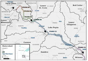
The South Metro Mississippi River TSS TMDL report (MPCA, 2015) was approved in 2016 to address aquatic life impairment related to excess total suspended solids (TSS). The report established TSS TMDLs for five stream reaches in the South Metro – Mississippi River (South Metro) watershed, extending from River Mile 844 (the confluence with the Minnesota River), to River Mile 780 (downstream of the confluence with the Rush River in Wisconsin). All known sources of TSS loading were considered in the development of the TMDL and general implementation strategy. These sources include:
- Stormwater runoff from MS4s
- Permitted point sources other than MS4s (e.g., wastewater treatment facilities)
- Agricultural sources
- Internal loading (i.e., resuspension of sediments)
- Streambank erosion
- Natural background loading
A large number of MS4s exist within the area tributary to the impaired reaches. For this reason, rather than develop individual WLAs for each MS4, the TMDL establishes a categorical WLA for all MS4s within the impaired watersheds. Specifically, based on review of the 2011 National Land Cover Database (NLCD) and review of allowable average sediment export rates from a variety of sources, the TMDL established the categorical WLA for all MS4s based on an estimated annual median export of 154 pounds of TSS per acre (154 lbs/acre/year) for all developed land uses. The TMDL and WLAs developed in the TMDL document include an estimate of existing loading (pounds of TP per year, lbs/yr), WLA TP loading, and pounds of TP reduction required by each MS4 to achieve the WLAs. TMDLs structured in this way provide clear guidance and reduction targets for included MS4s.
MS4 Compliance: Roseville
The following subsections provide an overview of reporting related to TMDL requirements and how the City of Roseville could use WinSLAMM to evaluate and demonstrate progress towards TMDL compliance. The links below provide information presented in the following subsections.
General TMDL Reporting Information:
Related to City of Roseville / South Metro Mississippi River TSS TMDL:
- South Metro Mississippi River TSS TMDL
- City of Roseville SWPPP Reauthorization Form (2013)
- City of Roseville TMDL Annual Report Form (2017)
Using WinSLAMM to Demonstrate WLA Compliance: Roseville
To track progress towards achieving their WLA target reduction goal, the City of Roseville may choose to use WinSLAMM to both track existing water quality BMP performance and evaluate implementation of proposed BMPs. WinSLAMM can be used to produce annual removal estimates for a large inventory of BMPs from a variety of land uses or source areas, and is therefore an acceptable model for evaluating WLA compliance. An overview of general steps which could be taken by Roseville to demonstrate compliance with the South Metro Mississippi River TSS TMDL using WinSLAMM is included below. More detailed information related to each step can be found in the links included in the TMDL reporting links table. Note: the case study example developed in this section is provided as an example of how an individual MS4 can demonstrate WLA compliance using WinSLAMM, and was not developed with input or coordination with the MS4 permittees.
1. Review applicable WLAs developed in the TMDL
The TMDL established the categorical WLA for all MS4s based on an estimated annual median export of 154 pounds of TSS per acre for all developed land uses.
2. Review the drainage area used to develop the TMDL
It is critical to determine the drainage area the TMDL applies to, as the WLA and required pollutant reduction apply only to the area tributary to the impaired waterbody. Because the WLA applies to the impaired water, pollutant reduction achieved within the MS4 but not within the tributary area to the impaired water does not apply to the required reduction targets developed by the WLA. Note: for TMDLs developed for large, regional waterbodies, the tributary MS4 area may be the entire municipal area (as is the case for Roseville within the watershed for the South Metro Mississippi River TSS TMDL). If the applicable MS4 area is not clearly outlined within the TMDL, mapping and associated digital files can be requested directly from the MPCA.
3. Review the TMDL modeling period and existing BMPs incorporated into the TMDL (i.e., determine the baseline condition used to establish the WLA
Before selecting an annualized model (i.e., models that produce annualized, rather than continuous results), it is critical to first make sure that applicable TMDLs are also developed on an annualized basis (e.g., required pounds of TP reduction per year). Review of the South Metro Mississippi River TSS TMDL shows that existing loading and TMDL loading was developed annually based on annual median export of 154 pounds of TSS per acre for all developed land uses. Because WinSLAMM estimates annual loading and BMP removal for any long-term precipitation records, it is a good candidate model for evaluating and demonstrating WLA compliance for this TMDL.
4. Develop an inventory of existing water quality BMPs related to the TMDL pollutant
There are many large wet ponds, wetlands, and lakes within Roseville that are tributary to South Metro Mississippi River impairments. Any BMPs constructed or implemented can be modeled and counted towards Roseville’s WLA reduction target. For this reason, it is critical that MS4s develop an inventory of all structural (e.g., infiltration BMPs) and non-structural BMPs (e.g., street sweeping) within the portion of the MS4 tributary to the impaired water body. For maintenance and tracking purposes, some MS4s may already have an established BMP inventory, while others will need to create a BMP inventory for the purposes of WLA compliance evaluation and tracking.
Examples of structural BMPs to inventory related to TSS reduction:
- Wet ponds
- Bioretention (i.e., rain gardens)
- Infiltration basins and trenches
- Sand filters and iron-enhanced sand filters
- Hydrodynamic separators (i.e., grit chambers)
- Alum and ferric chloride treatment plants
- Spent lime filtration
Some examples of non-structural BMPs to inventory related to TSS reduction:
- Street sweeping
- City ordinances (e.g., related to fertilizer application)
- Public education and outreach
5. Develop WinSLAMM model to evaluate WLA compliance
After review of the TMDL and development of the existing BMP inventory, the next step is to develop a WinSLAMM model for the drainage area outlined in the TMDL (see step #2). Note: a number of methods (e.g., monitoring) and models (e.g., the MPCA Simple Estimator) can be used to evaluate TMDL compliance, however, because this section focuses on the WinSLAMM, the following steps reference model development and analysis using the WinSLAMM.
- a. Develop inputs for existing BMPs and incorporate into the model
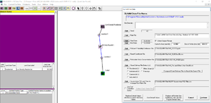
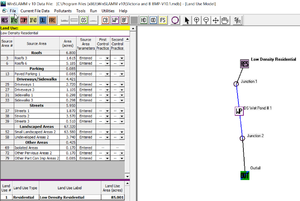
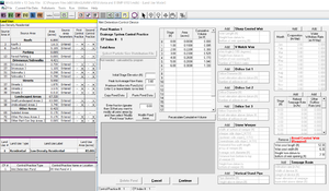
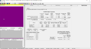
- An example of WinSLAMM job control parameters and drainage area inputs for a wet pond in Roseville treating stormwater runoff are shown in the adjourning image. The watershed and BMP inputs for the wet pond are assumed for the purposes of this example case study.
- Note: although this example illustrates a model set up to review one (1) BMP, typically, an MS4 will use one model to evaluate either (a) the entire municipal area, (b) individual models for major watersheds within the MS4 boundary, or (c) the MS4 area tributary to the impaired waterbody, meaning that WinSLAMM can model and produce results for many water quality BMPs.
- b. Determine existing load reduction and compare to WLA
- After generating inputs for all BMPs incorporated into the WinSLAMM model, the WinSLAMM model can be run to determine existing load reduction. In the case of the South Metro Mississippi River TSS TMDL, it is recommended that any additional TSS reduction beyond the existing conditions model represent progress towards the target WLA load reduction, and can be counted towards achieving the WLA target reduction value established in the TMDL. For the wet pond example shown in the adjourning figures, based on the assumed drainage area and BMP dimensions, Roseville could take credit for the 4,881 lbs/yr of particulate solids removal calculated at this BMP (as the difference between yield without controls, and with controls, shown in the adjourning figure) and apply this reduction to their target WLA of 154 pounds of TSS per acre for all developed land uses by comparison with the “Outfall Total with Controls” yield.
6. Review the TMDL implementation plan, Watershed Restoration and Protection Strategies report, Use Attainability Analysis (UAA) report, or other relevant watershed planning documents (if applicable)
If the TMDL does not include an implementation plan or does not develop specific recommendations related to BMP implementation, results for the existing conditions WinSLAMM can be used to target areas for BMP implementation. One method of identifying and targeting areas of high pollutant loading within the modeled watershed for BMP implementation is to calculate the “watershed pollutant areal loading (pre-treatment) (lbs/acre/year)” and “outflow pollutant areal loading (post-treatment) (lbs/acre/year)” as outlined in this table. Joining these results to modeled subcatchment areas allows the user to visualize “hot spots” of pollutant loading generated from the watershed without controls (pre-treatment) and leaving the modeled BMP with controls (post-treatment). An example showing watershed pollutant areal loading for the existing conditions for a different TMDL and lake area, the Lake Riley RP TMDL, is shown here. As can be seen, watershed pollutant loading is correlated to land use, with more-developed portions of the watershed generating more TP loading than less-developed areas.
7. Utilize model to track progress towards meeting the WLA (e.g., use the model to evaluate BMPs and incorporate BMPs as they are implemented)
As discussed in item #6, above, the existing conditions WinSLAMM model can be used to identify areas to target for BMP implementation, and can be updated as BMPs are constructed to track progress towards attaining WLA compliance. The TMDL implementation plan provides cost estimates guidance regarding the implementation of rain gardens throughout developed portions of the watershed.
This page was last edited on 22 November 2022, at 22:03.

