Navigation
Main page
Table of contents
Index (Categories)
What's new
Response to comments
Future updates
Events
In the News
Funding
Recent changes
Help
Export to pdf
Tools
User contributions
Logs
View user groups
Special pages
Printable version
MPCA Links
MPCA Homepage
Stormwater
Policies / Disclaimers
Minnesota Stormwater Manual
Search Help
Log in
Search:
Search
Uploads by PLeegar
2020 MS4 General Permit TMDL Application
>
Special:WhatLinksHere/File:Minnesota surficial geology.jpg
>
Bacteria in stormwater
>
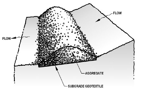
Infiltration trench
>
Special:ListFiles
This special page shows all uploaded files.
File list
Items per page:
20
50
100
250
500
Search for media name:
Username:
Include old versions of files
Go
First page
Previous page
Next page
Last page
Date
Name
Thumbnail
Size
Description
Versions
20:22, 21 June 2016
Topsoil thickness.png
(
file
)
34 KB
1
19:03, 16 July 2015
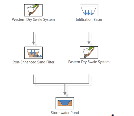
New Development Varied BMP Treatment Train MIDS Calculator Schematic.PNG
(
file
)
35 KB
1
15:59, 15 March 2016
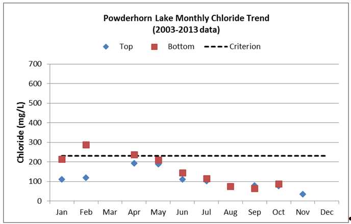
Average monthly chloride concentrations in top and bottom samples in Powderhorn Lake.PNG
(
file
)
36 KB
1
14:54, 17 January 2013
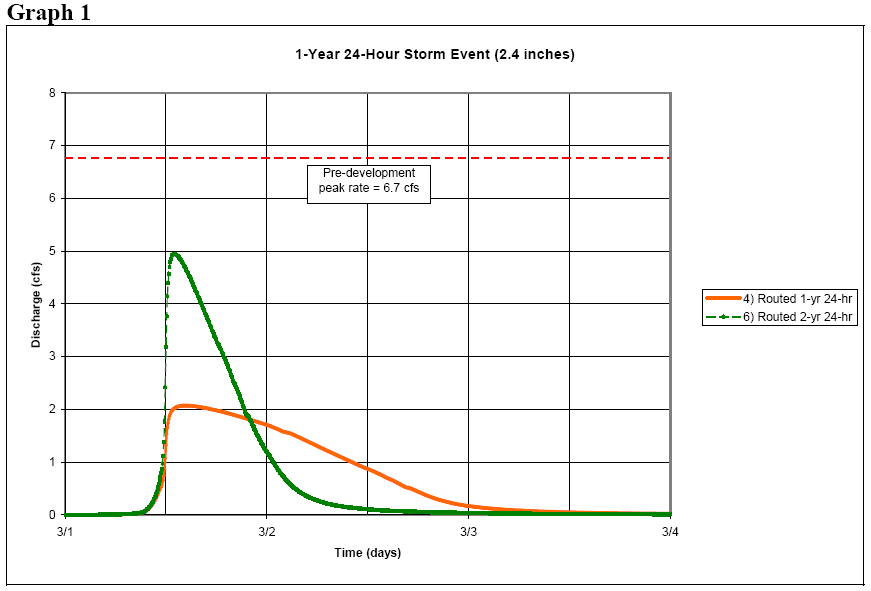
1 year 24 hour event.png
(
file
)
36 KB
1
15:42, 17 January 2013
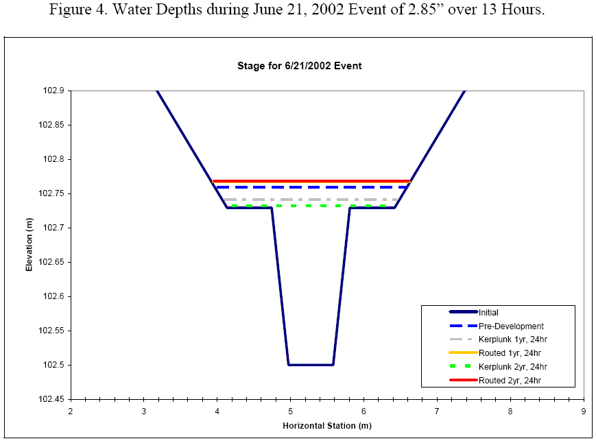
Water depth during June 21 event.png
(
file
)
36 KB
1
15:41, 17 January 2013
Water depth during August 16 event.png
(
file
)
36 KB
1
20:09, 1 February 2016
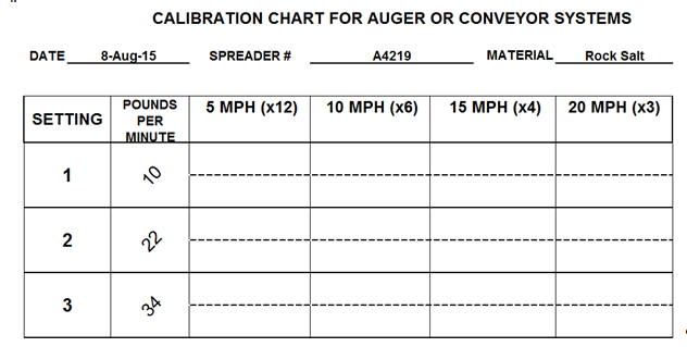
Steps for Calebrating an auger or conveyor system.png
(
file
)
37 KB
1
19:18, 14 January 2013
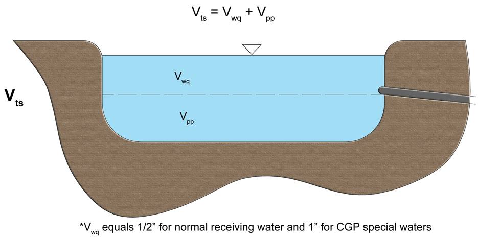
Schematic of total storage volume.jpg
(
file
)
37 KB
2
20:18, 1 March 2016
Slope tracking roughens the surface of a slope and decreases the velocity of runoff.PNG
(
file
)
37 KB
1
21:12, 24 October 2016
Space check dams in a channel so the crest of the downstream dam is at the elevation of the toe of the upstream dam.jpg
(
file
)
38 KB
1
19:07, 17 August 2016
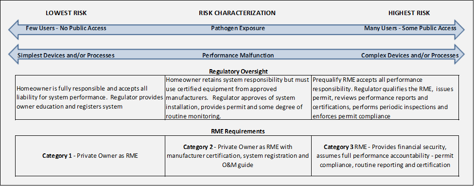
Risk characterization stormwater reuse.png
(
file
)
38 KB
1
19:12, 4 September 2013
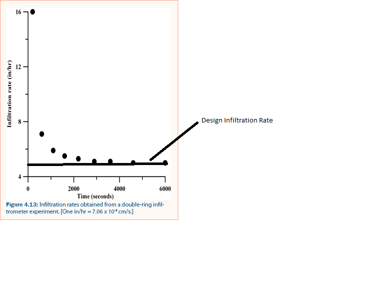
Infiltration Rate - double-ring infiltrometer.png
(
file
)
38 KB
1
19:10, 18 June 2013
Stormwater reuse for irrigation performance curve – watershed 90 percent impervious.png
(
file
)
38 KB
1
19:10, 18 June 2013
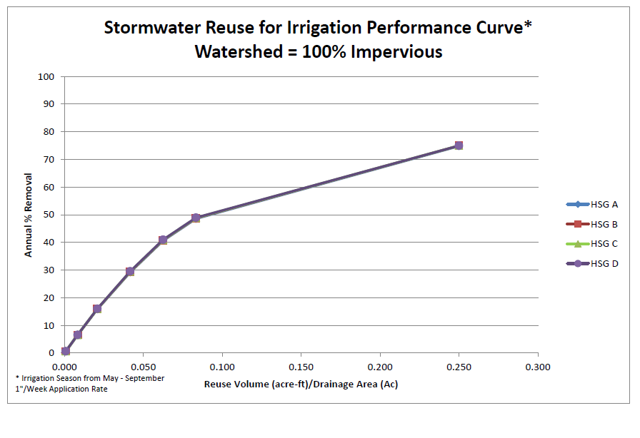
Stormwater reuse for irrigation performance curve – watershed 100 percent impervious.png
(
file
)
38 KB
2
16:00, 25 May 2016
CSW search tool.PNG
(
file
)
38 KB
1
20:12, 16 January 2013
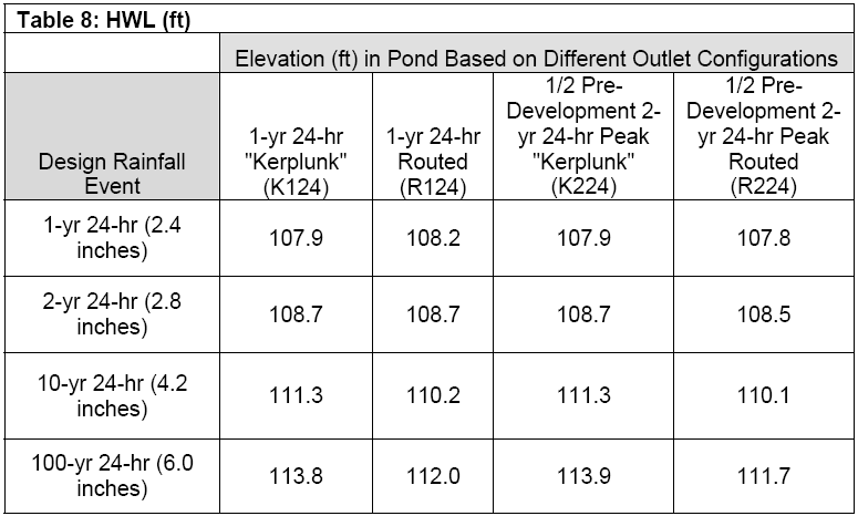
AppOTable8.png
(
file
)
39 KB
1
19:46, 14 March 2016
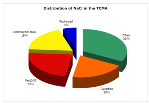
Distribution of NaCl in the TCMA (Figure adapted from Sander et al.PNG
(
file
)
40 KB
1
19:09, 18 June 2013
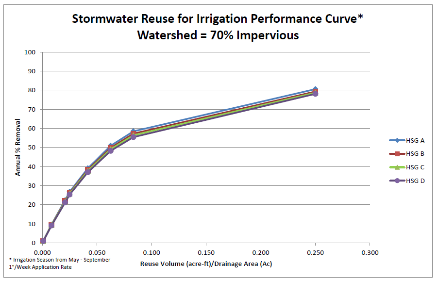
Stormwater reuse for irrigation performance curve – watershed 70 percent impervious.png
(
file
)
41 KB
2
17:05, 29 January 2016
Roadsalt-goodhuepolicy.pdf
(
file
)
41 KB
1
18:58, 24 October 2016
Example perimeter control berm.jpg
(
file
)
41 KB
1
15:04, 15 March 2016
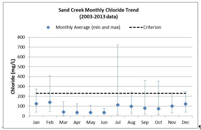
Monthly chloride concentrations (average, maximum, and minimum) in Sand Creek.PNG
(
file
)
41 KB
1
16:31, 10 January 2013
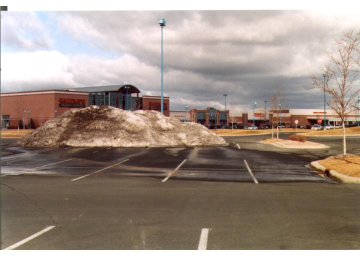
Snow plowed and piled in parking lot.jpg
(
file
)
41 KB
1
19:38, 14 March 2016
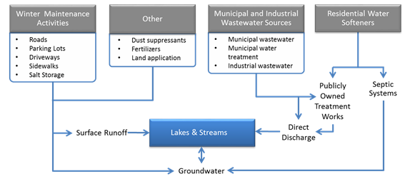
Conceptual model of anthropogenic sources of chloride and pathways.PNG
(
file
)
41 KB
1
15:09, 15 March 2016
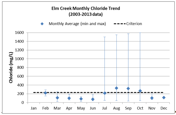
Monthly chloride concentrations (average, maximum, and minimum) in Elm Creek.PNG
(
file
)
42 KB
1
18:14, 23 September 2016
FINAL Guidance Document 08-25-16 Clean.docx
(
file
)
42 KB
1
17:09, 29 January 2016
Roadsalt-eaganpolicy.pdf
(
file
)
42 KB
1
20:08, 21 June 2016
Grain Size.PNG
(
file
)
42 KB
1
19:09, 18 June 2013
Stormwater reuse for irrigation performance curve – watershed 50 percent impervious.png
(
file
)
42 KB
1
21:04, 10 January 2013
Snow collected in off site large storage area.jpg
(
file
)
43 KB
1
19:25, 28 January 2013
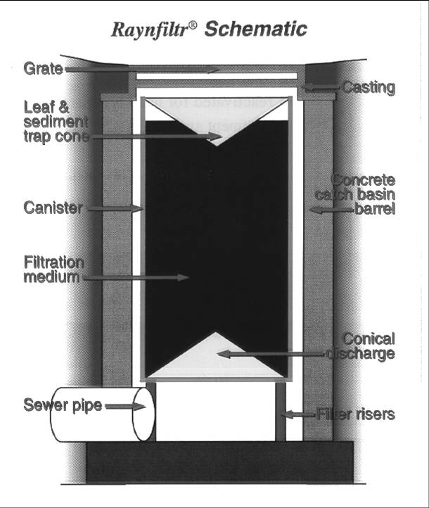
Image of proprietary device 2.jpg
(
file
)
43 KB
1
20:40, 1 February 2016
Calibration chart for auger or conveyor systems step 2.PNG
(
file
)
43 KB
1
20:03, 18 October 2016
Example riprap stilling basin plunge pool installation.jpg
(
file
)
43 KB
1
21:52, 16 May 2016
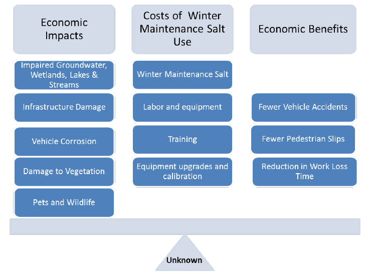
Cost Considerations Related to Winter Maintenance Salt Use.PNG
(
file
)
44 KB
1
19:08, 18 June 2013
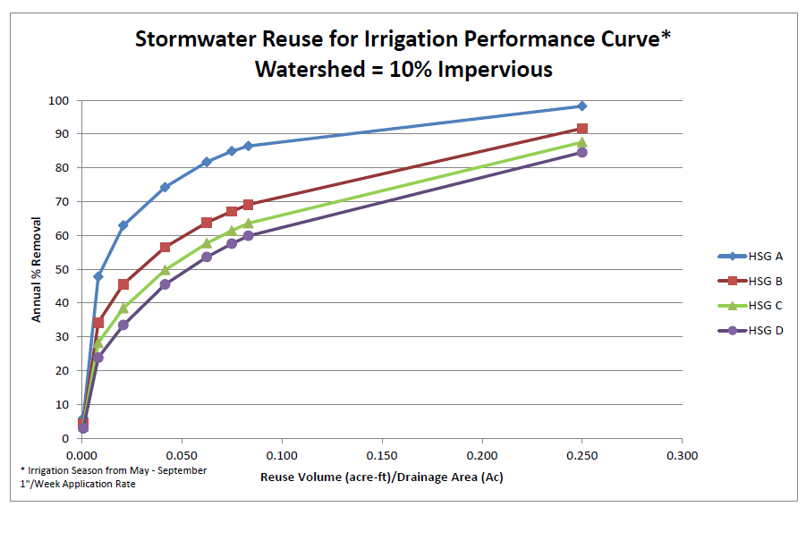
Stormwater reuse for irrigation performance curve – watershed 10 percent impervious.png
(
file
)
44 KB
1
19:33, 18 June 2015
Urban Retrofit BMP Treatment Train MIDS Calculator Schematic.PNG
(
file
)
44 KB
1
16:23, 23 January 2013
Emission regulation.jpg
(
file
)
44 KB
1
20:48, 18 August 2016
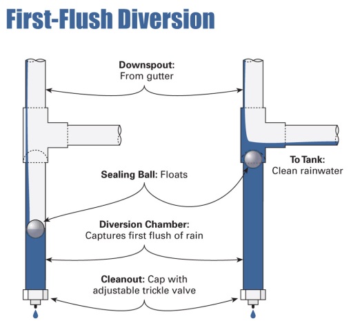
First Flush Device.jpg
(
file
)
44 KB
1
19:08, 18 June 2013
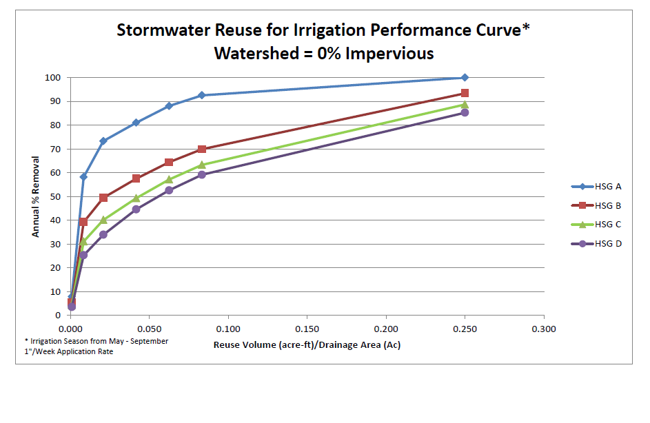
Stormwater reuse for irrigation performance curve – watershed 0 percent impervious.png
(
file
)
45 KB
1
15:56, 20 December 2017
Normal distribution.png
(
file
)
45 KB
1
16:23, 16 May 2016
Comparison of Impaired Streams in the TCMA 2003-2013.PNG
(
file
)
45 KB
1
19:08, 18 June 2013
Stormwater reuse for irrigation performance curve – watershed 30 percent impervious.png
(
file
)
46 KB
1
19:52, 18 October 2016
Design of outlet protection for a round pipe flowing full with minimum tailwater condition.png
(
file
)
46 KB
1
19:01, 5 February 2013
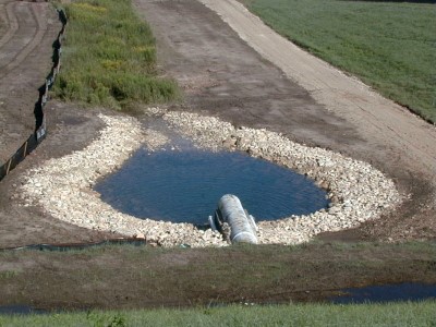
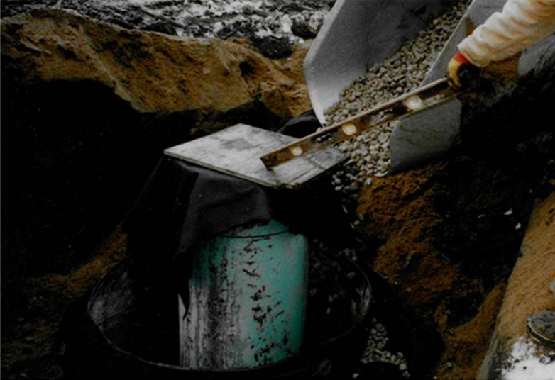
Construction of infiltration trench 2.jpg
(
file
)
46 KB
1
14:54, 17 January 2013
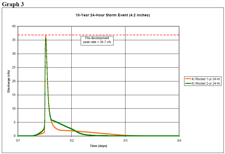
10 year 24 hour event.png
(
file
)
46 KB
1
19:05, 29 June 2016
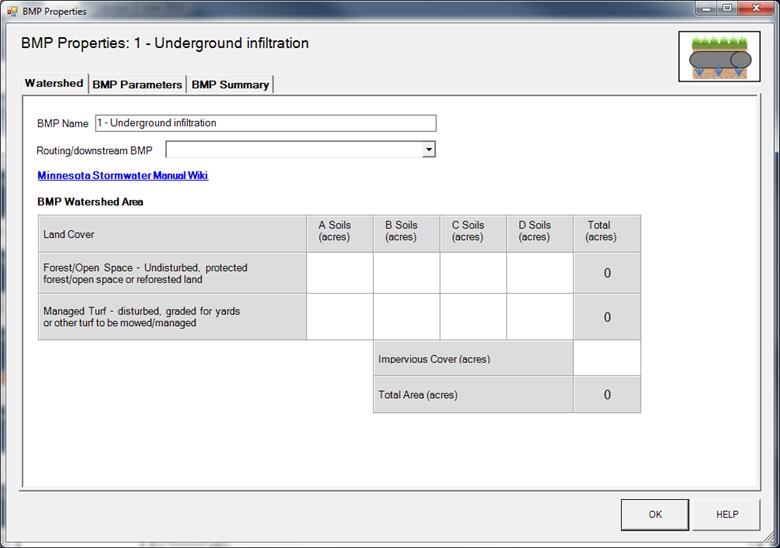
BMP Properties 1 - Underground infiltration.jpg
(
file
)
47 KB
1
16:04, 16 May 2016
Comparison of Impaired Lakes and Wetlands in the TCMA from 2003-2013.PNG
(
file
)
48 KB
1
20:12, 22 June 2015
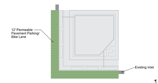
Permeable Pavement Layout.PNG
(
file
)
48 KB
1
21:03, 9 January 2013
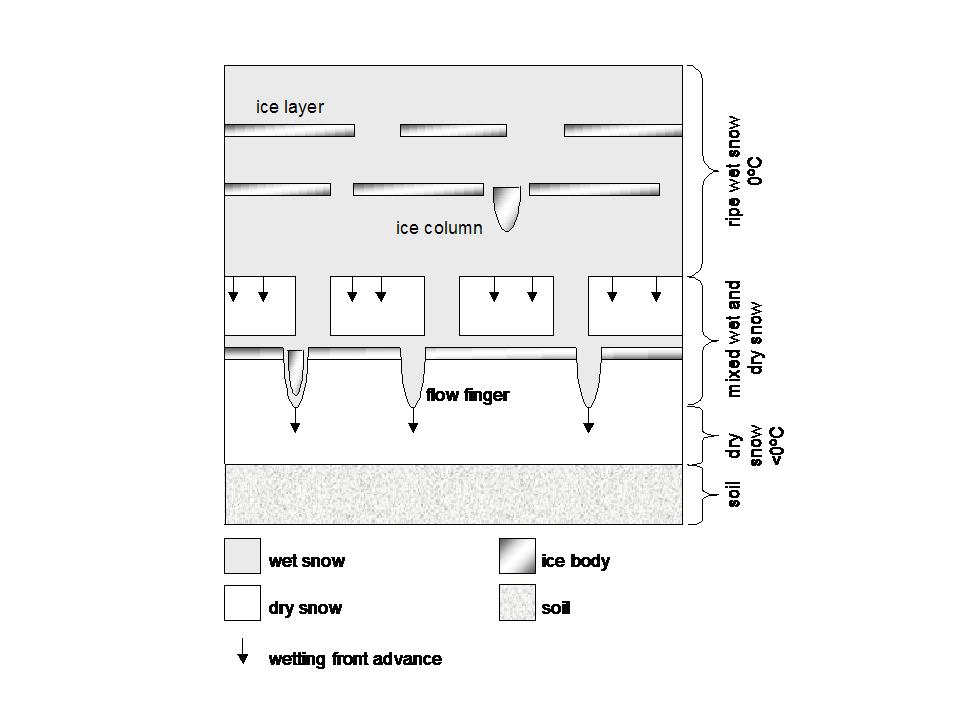
Percolation of water through snowpack.jpg
(
file
)
48 KB
1
22:10, 15 July 2015
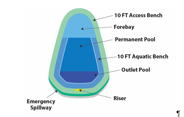
Stormwater Pond Level 3 Design Parameters.PNG
(
file
)
49 KB
1
19:25, 28 January 2013
Image of proprietary device 1.jpg
(
file
)
49 KB
1
First page
Previous page
Next page
Last page
Search:
Search
Privacy policy


_in_Sand_Creek.PNG)


_in_Elm_Creek.PNG)


