Screening assessment for contamination at potential stormwater infiltration sites Revision as of 22:29, 16 February 2023 by Mtrojan (talk | contribs) (→Conducting a property review)
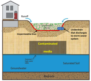
The Minnesota Construction Stormwater permit states "Permittees must design and construct a permanent stormwater treatment system to treat the water quality volume if the project's ultimate development replaces vegetation and/or other pervious surfaces creating a net increase of one (1) or more acres of cumulative impervious surface. Permittees must calculate the water quality volume as one (1) inch times the net increase of impervious surfaces created by the project. Permittees must first consider volume reduction practices on-site (e.g., infiltration or other) when designing the permanent stormwater treatment system ... For projects where the full volume reduction requirement cannot be met on-site, (e.g., the site has infiltration prohibitions), permittees must document the reasons in the SWPPP."
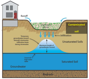
The Minnesota Construction Stormwater permit prohibits infiltration in areas where high levels of contaminants in soil or groundwater will be mobilized by the infiltrating stormwater. At sites not covered by the permit, infiltration should not be used to manage stormwater if high levels of contaminants will be mobilized by infiltrating stormwater. Stormwater infiltration that mobilizes high levels of contaminants is a permit violation and may result in liability concerns.
Disregarding other potential prohibitions on infiltration, the language in the permit indicates that one inch of runoff must be retained on site unless high levels of contaminants will be mobilized. High levels of contaminants and mobilize are not clearly defined. This page provides information to help determine if stormwater infiltration could mobilize high levels of contaminants that may exist at a site. The guidance presents a screening level process that is not intended to confirm the presence or absence of contamination, but identify sites where there is a reasonable potential for contamination to exist and be mobilized by stormwater infiltration. This discussion is not intended for sites with known contamination (see Stormwater infiltration guidance for sites with known or high potential for soil or groundwater contamination on or off-site). For additional information, see Brownfield Program Response Action Plans for guidance on sites with known contamination.
Contents
- 1 Checklist for determining appropriateness of stormwater infiltration
- 2 Information for conducting a screening assessment
- 2.1 Does the site have soil or groundwater contamination or a history of contamination at levels of concern?
- 2.2 Has a contaminated site been remediated to acceptable levels?
- 2.3 Conducting a property review
- 2.4 Conducting a site visit and determining an influence zone
- 2.5 Determining if adequate separation can be achieved between a potential contamination source and the BMP
- 3 Example screening assessments
- 4 What if I want to pursue infiltration even if my site may be contaminated?
- 5 Liability issues
- 6 Related pages
Checklist for determining appropriateness of stormwater infiltration
A checklist was developed to assist in determining whether infiltration could potentially mobilize contaminants at a site. Information that may assist in completing the checklist is provided in the following sections on this page. The checklist can be accessed at the following link.
- Checklist: File:Contamination screening checklist for stormwater infiltration.xlsx or File:Contamination screening checklist for stormwater infiltration July 2018.xlsx
Note that infiltration is prohibited when the infiltration system will be constructed in areas that receive discharges from vehicle fueling and maintenance. The spreadsheet mentioned above and the guidance on this page are not applicable to vehicle fueling and maintenance sites.
Information for conducting a screening assessment
The goal of this screening assessment is to provide sufficient information to make a determination about whether or not to infiltrate at a site without having to conduct a Phase 1 Environmental Site Assessment (ESA). Phase 1 ESAs are typically recommended at sites that have a reasonable likelihood of being contaminated and involves a review of records, a site inspection, and interviews with owners, occupants, neighbors and local government officials.
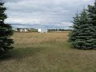
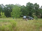
The following screening assessment is primarily for sites that are less likely or unlikely to have contaminated soils or groundwater. Examples of sites that typically represent low risk are undisturbed lands, residential areas, light commercial areas, and most agricultural areas. Examples of land uses that typically represent low risk or moderate risk are shown in the two photo galleries below. This section provides information and links to resources that can be used to complete a screening assessment and the screening checklist.
- Examples of different land uses that typically represent a low risk of being contaminated. Click on an image to enlarge and to read recommendations for investigating the site.
- Examples of different land uses that may represent a moderate risk of being contaminated. Click on an image to enlarge and to read recommendations for investigating the site.
Does the site have soil or groundwater contamination or a history of contamination at levels of concern?
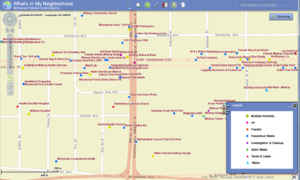
If a site has soil or groundwater contamination, there is a reasonable likelihood that contaminants at the site will be mobilized by stormwater infiltration. Contaminated sites include Brownfield sites, Superfund sites, petroleum leak sites or other sites where contamination is known to exist. Tank sites, solid waste sites, and hazardous waste sites do not necessarily have contamination and additional information should be sought to determine if these sites have contaminated soil or groundwater. Available tools include USEPA’s EnviroMapper or the MPCA’s What’s in My Neighborhood (recommended). What’s in My Neighborhood includes contact information for individual sites.
Although a site may be contaminated or may have had contamination, the contaminants may not exist at levels of concern or the site may have been remediated to acceptable levels. The next section on this page discusses how to determine acceptable levels of contamination.
For Construction Stormwater permittees, infiltration is prohibited when the infiltration system will be constructed in areas where high levels of contaminants in soil or groundwater will be mobilized by the infiltrating stormwater. If infiltration is pursued at a site with known soil or groundwater contamination, a Phase 1 or Phase 2 investigation should be conducted to confirm the location(s) of contamination and ensure that infiltration will not mobilize the contaminants.
Has a contaminated site been remediated to acceptable levels?
Many contaminated sites have been cleaned up (remediated) to levels where stormwater infiltration is acceptable, or contaminants may be present at concentrations that do not represent a risk. The following conditions constitute sites that are likely to be acceptable for stormwater infiltration.
- Soils that meet residential Soil Reference Values (SRVs). SRVs are soil contaminant-specific concentrations above which an unacceptable risk to human health is predicted. The SRVs are derived by MPCA staff using risk assessment methodology, modeling, and risk management policy. Residential SRVs, also called Tier 1 SRVs, represent the highest standard of remediation for soil. Sites remediated to residential SRVs are considered to represent no risk for human exposure. See Soil-human pathway documents and list of SRVs on MPCA’s Risk-based site evaluation guidance web page.
- Groundwater concentrations that meet Health Risk Levels (HRLs), Health-Based Values (HBVs), and Maximum Contaminant Levels (MCLs). These represent site cleanup levels for individual contaminants to protect human receptors from unacceptable risk associated with ground water contamination. See Groundwater pathway documents on MPCA’s Risk-based site evaluation guidance web page.
- Soils that meet soil-to-groundwater leaching values (SLVs). The SLV is an estimation of the unsaturated soil contaminant concentration for a given compound above which may result in groundwater contamination in excess of chemical specific drinking water criteria. See Soil to groundwater leaching pathway documents on MPCA’s Risk-based site evaluation guidance web page.
The MPCA provides closure letters at petroleum leaksites that pose no risk to receptors on- or off-site at the time the letter was sent. A closure letter does not guarantee that contamination has been completely removed from a site. Contaminants not posing a risk to receptors are left in-place to biodegrade. This means “closure” does not equate to “clean”, rather it means the remaining pollution is not a risk to human health or the environment. See MPCA's Petroleum Remediation Program web page for more information.
- If a closure letter was sent by the MPCA for the site in question, determine if contamination still exists at the property. This may be done by contacting the MPCA to review reports and other information for the site or through a Phase II environmental site assessment.
- If a closure letter was sent by the MPCA for an adjacent property, there may still be contamination on the adjacent property. Infiltration is appropriate if adequate separation can be achieved between the infiltration BMP and the off-site contamination. See the section on determining if adequate separation can be achieved between a potential contamination source and the BMP.
The MPCA provides assurance letters at Brownfield sites that pose no risk to receptors on-site. If the MPCA has issued an assurance letter, assume the site has been remediated to acceptable levels. An assurance letter provides no guarantees for off-site contamination. If off-site contamination exists, infiltration is appropriate if adequate separation can be achieved between the infiltration BMP and the off-site contamination. See the section on determining if adequate separation can be achieved between a potential contamination source and the BMP. See MPCA's Brownfields program web page for more information.
Cleanup at sites that have undergone remediation should be documented. For example, remediated sites that are included in MPCA's What's in my Neighborhood? should have associated documents and contact information.
Conducting a property review
There are several resources available for determining the current and past uses of a specific property. The following information sources and methods are readily available without needing to hire a consultant.
- Conduct a review of property history to identify past uses of the property. The following information sources can be utilized as available.
- Street directories
- Aerial photographs
- Topographic maps
- Sanborn, Kroll, Metzker and/or other historical maps
- Historical tax assessor records
- Interview persons knowledgeable of the property and area to obtain current and historical information. If additional historical information is needed, review historical records to identify past practices that may have contaminated soils or groundwater at the site. Specifically ask all property owners if they are aware of existing or past sources of potential contamination, such as sumps and tanks.
- Examination of state and federal records to identify if the property and adjacent or nearby properties or businesses are documented hazardous waste generators and/or are known or suspected of having contamination. Hazardous waste generators can be identified using the MPCA’s What’s in My Neighborhood online tool.
- Review of information provided by the owner, such as prior environmental reports, information on environmental cleanup liens, activity and land use limitations, purchase price relative to fair market value of the property, commonly known information regarding the property, as well as the chain-of-title, site drawings, and other pertinent information.
- Reports that present findings, opinions, and conclusions regarding contamination or the potential for contamination on or near the site.
The following sources may provide useful information in completing a property review.
- U.S. EPA’s EnviroMapper and the MPCA’s What’s in My Neighborhood are online tools to identify specific sites and locations of concern.
- The University of Minnesota John R. Borchert on line map directory provides online maps, including topographic maps and city maps. Specific websites with information include the following.
- The Minnesota Historical Society holds more than 950 Sanborn Fire Insurance maps.
- The University of Minnesota provides historical aerial photos on-line.
- The State of Minnesota provides on-line access to assessor and property tax records.
Conducting a site visit and determining an influence zone
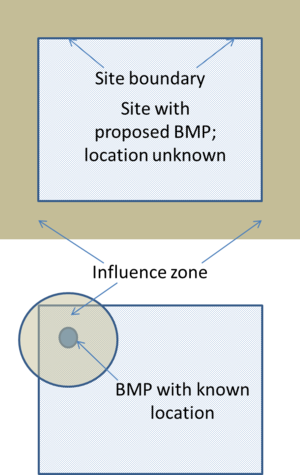
A site visit should be conducted to visibly identify features that may indicate the presence of contamination. This site visit includes a walking survey of the site and all properties within the influence zone of the proposed infiltration practice.The influence zone is the distance from a BMP at which a groundwater plume from the BMP would not intersect contamination. If the BMP location is not known, then assume the BMP is located at the property boundary and that groundwater flows on to adjacent property. For example, using the table below, if the soil beneath the BMP was fine sand and the underlying aquifer was coarse sand, the influence zone would extend 75 feet. This means during the site visit you would look for potential sources of contamination within 75 feet of your property boundary or the closest boundary of the proposed practice. Any feature detected beyond 75 feet would not be considered a concern for mobilizing contamination as a result of stormwater infiltration. Inspect the interior of all buildings, particularly in industrial areas. Look for the presence of presence of tanks, floor traps, etc.
| Influence zone distance (feet) | ||
| Soil beneath BMP | Aquifer material | Influence zone distance (feet) |
| Any soil | Fine sand or finer | 75 |
| Coarse sand | Coarse sand | 150 |
| Coarse sand | Gravel | 800 |
| Fine sand | Coarse sand | 75 |
| Fine sand | Gravel | 500 |
| Silt or finer | Coarse sand or finer | 75 |
| Silt or finer | Gravel | 150 |
| Unregulated fill | Coarse sand | 75 |
| Unregulated fill | Gravel | 500 |
| The influence zone distance was determined using a USGS groundwater mounding calculator with conservative assumptions (a 300 foot long practice with a maximum ponding depth of 4 feet). Hydraulic conductivity of the aquifer and daily recharge rate were varied to correspond with the soil and aquifer materials shown in the table. The calculator computes the extent of a mound that develops beneath the infiltration BMP. The resulting values were multiplied by a safety factor of 2 to give the influence zone distances. | ||
Presence of any of the following features may indicate potential contamination.
- Underground storage tank vents or fill ports. These are typically associated with an underground tank, such as gasoline. Consult the property owner or other people that may be familiar with the site or site history to determine the origin of the feature. If an underground tank was or is present at the site, determine what the tank was used for. Other information that may be useful includes information on the tank (size, material, etc.), where it is located (depth, etc.), when it was installed, if it was removed, has it been inspected or maintained, and is there any history of contamination associated with the tank.
- Monitoring wells. Monitoring wells are typically associated with water quality monitoring, often at sites where groundwater is contaminated. Monitoring wells are typically 4 inches or less in diameter, often being 2 inches in diameter (compared to domestic wells, which are 4 inches or greater in diameter). All wells should have an identifier plate attached to the well. A unique ID is shown on the plate. If the well has a Unique ID, it should exist in the Minnesota Department of Health's County Well Index, thereby allowing a person to find information about the well on-line. Note that many monitoring wells are installed up-gradient of contaminated sites and are therefore in "clean" groundwater. Water quality information should be available for many monitoring wells.
- Soil piles covered with plastic sheeting or tarps. Soil that is stockpiled at a site should be investigated for odors and staining. Consult the property owner or people knowledgeable with the site to determine why soil is being stockpiled. Determine if the soil has been sampled and, if it has, obtain the sampling information.
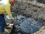
- Staining of soils and/or dead vegetation. These may be indicative of a wide range of contaminants. Petroleum-stained soils are relatively easy to identify and will show black staining. Patches of dead vegetation, particularly if adjacent to healthy vegetation, may indicate areas of contamination. Toxic levels of metals are often indicated by dead vegetation. If soil staining and/or dead vegetation is observed on a site, consult with the property owner or people knowledgeable with the site to determine the cause of the staining and/or dead vegetation.
- Unusual odors. The most common odors indicative of contamination will be from volatile organic chemicals, such as gasoline, fuel oils, and solvents. If odors are detected contact the property owner or people knowledgeable with the site to determine the source of the odors. Sites with historic use of volatile organic chemicals may have significant contamination, while odors at some sites may simply be the result of a small spill.
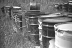
- Mismanaged drums. Drums containing chemicals typically should not be stored outdoors. Any outdoor area with stored drums should be viewed as a potential source of contamination. Through interviews with property or business owners, determine the contents and condition of the drums. Similarly, drums that are handled outdoors represent a potential contamination concern. Examine the handling area to determine if spills have occurred and ensure that proper spill response procedures are in place. More information on outdoor handling of materials can be found on the page addressing potential stormwater hotspots.
- Excavations that are not backfilled with clean material. Excavations should be treated similar to soil piles since they represent a situation where soil has been removed for some reason. Determine why soil was excavated and examine the excavation area to identify any odors or staining.
- Presence of debris that may indicate presence of structures or activities that could result in contamination. Examine the debris to determine if anything represents a potential source of contamination. Examples include empty paint or pesticide cans, caulking tubes and other construction materials, and machinery that contains or may have contained fluids. Examine the area for staining and odors. Contact the property owner or people knowledgeable with the site to determine the source of the debris. This should be done even if the debris appears harmless (e.g. wood or metal piles) since there may have been other materials or activities that could result in contamination.
- Site is a confirmed stormwater hotspot. Potential Stormwater Hotspots (PSHs) are activities or practices that have the potential to produce relatively high levels of stormwater pollutants. Designation as a PSH does not imply that a site is a hotspot, but rather that the potential to generate high pollutant runoff loads or concentrations exists. Common operations and areas for assessing PSHs include management of turf, waste, loading docks, downspouts, vehicle fueling, and parking lots. See the page on potential stormwater hotspots for additional information.
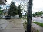
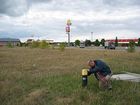
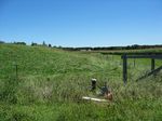
- Examples of different features that may indicate the presence of contamination. Click on an image to enlarge and for more information.
Determining if adequate separation can be achieved between a potential contamination source and the BMP
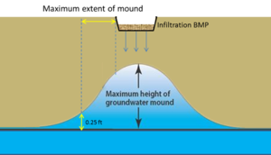
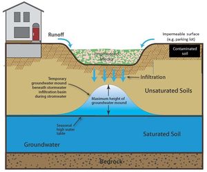
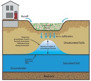
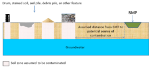
Even if contamination exists on a site or an adjacent property, an infiltration BMP may be located a safe distance from the contamination. This would be the distance at which contaminants will not be mobilized by infiltrated stormwater. This safe distance, called a setback or separation distance, can be determined using a simple tool developed by the United States Geological Survey (USGS). The separation distance is based on the assumption that a groundwater mound develops directly beneath the infiltration BMP. The USGS tool is a spreadsheet that calculates the extent of a groundwater mound that develops beneath an infiltration practice. The maximum extent of groundwater mounding is defined as a 0.25-ft water-level increase at a distance measured from the edge of the hypothetical infiltration basin (see USGS study). It is recommended that the calculated maximum extent of a mound be increased by a safety factor of 2. For example, if it is 50 feet from the edge of a BMP to a point where the underlying mound is 0.25 feet, the minimum acceptable distance from the edge of the mound to a point of contamination is 100 feet (50 times the safety factor of 2). That is, the infiltration practice should be no closer than 100 feet from the point of contamination. If soil on an adjacent site is contaminated but it is uncertain what depth the contamination extends to, assume the contamination extends to the underlying groundwater table (see figure at upper right).
Inputs needed for using the spreadsheet include the following.
- Infiltration rate of soil underlying the BMP. These may be measured values or values taken from tables.
- Specific yield of the aquifer material. This can be determined from this table.
- Hydraulic conductivity of the aquifer material. This can be determined from this table.
- Length and width of the basin. The spreadsheet calculates the plume in the x direction, which is called the length in the spreadsheet.
- Duration of infiltration. This is the length of time it takes the water captured by the BMP to infiltrate. For example, if the ponded depth in a BMP is 1.5 feet and the infiltration rate in the soil underlying the BMP is 1 foot per day, the duration time is 1.5 days.
- Initial thickness of the aquifer (saturated zone). This is the most difficult value to obtain since it requires subsurface sampling, but most water table aquifers are relatively thin. We therefore recommend using a value of 10 feet if data do not exist.
For guidance on using the calculator, link here.
Note that identifying the source of groundwater contamination is not the same as identifying the location of contaminated groundwater. If activities on adjacent properties may have resulted in groundwater contamination, determine where potential or actual groundwater plumes exist and determine groundwater flow at the potential infiltration site. This may be done either from information collected at the adjacent site if it exists, or from local groundwater flow maps. Determine whether groundwater contaminants would be mobilized by stormwater infiltration.
For more information see How to predict the extent of a mound. Example applications of this tool can be viewed in this document File:Plume examples 2.docx.
Example screening assessments
The following examples utilize the above guidance, including the screening assessment (see File:Contamination screening checklist for stormwater infiltration.xlsx or File:Contamination screening checklist for stormwater infiltration July 2018.xlsx).
Example 1
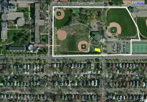
A bioinfiltration basin (rain garden) is proposed on city land currently used for recreation. Soils in the area of the proposed BMP are fine sands and the aquifer material is coarse sand, giving an Influence zone distance of 75 feet. The surrounding land use within 75 feet of the proposed BMP is single-family residential and a college. Interviews with the property owner indicate the site is not contaminated and has no history of contamination.There are no observed potential sources of contamination on the property. On an adjacent property a small quantity hazardous waste generator was identified using What's in My Neighborhood. Interviews with the owner of the small quantity hazardous waste generator indicates there is no history of contamination and the potential for contamination is very low. A site visit indicates there are no identified sources of contamination within 75 feet of the proposed BMP. Using the screening checklist, infiltration is deemed appropriate for this site. To see the checklist for this site, follow this link (File:Contamination screening checklist for stormwater infiltration.xlsx or File:Contamination screening checklist for stormwater infiltration July 2018.xlsx) and click on the worksheet called Example 1.
Example 2
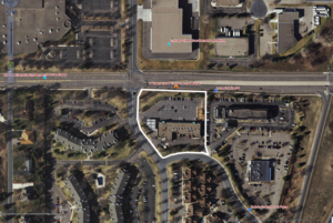
An existing parking lot will be replaced by a permeable pavement parking lot. Land use at the site of the proposed BMP is commercial business. The underlying soil is fine sand and the aquifer material is gravel, giving an Influence zone distance of 500 feet. Adjacent land uses (within 500 feet of the proposed BMP) include multiple-family residential, commercial, and industrial. There are also high volume transportation corridors within 500 feet of the proposed BMP. Interviews with the property owner indicate there is no known contamination on the site. Using What's in My Neighborhood, an old tank leak site is identified adjacent to the property. Clicking on the tank site in What's in my Neighborhood and opening the document associated with the site indicates a closure letter was issued by the MPCA 20 years ago indicating the site has been adequately addressed.
The next step is to conduct a site visit. The visit reveals no evidence for contamination. However, industries north of the property are within 500 feet of the proposed BMP. Loading docks are present at one of the industrial facilities. Loading docks represent a potential stormwater hotspot. Using the guidance on potential stormwater hotspots it is determined there are no activities that represent a contamination risk. It is therefore determined that infiltration is appropriate at this site.
Note that we could have conducted a mounding analysis for the BMP to determine if adequate separation could be achieved from the loading dock. This would assume the loading dock was a source of contamination.
To see the checklist for this site, follow this link (File:Contamination screening checklist for stormwater infiltration.xlsx or File:Contamination screening checklist for stormwater infiltration July 2018.xlsx) and click on the worksheet called Example 2.
Example 3
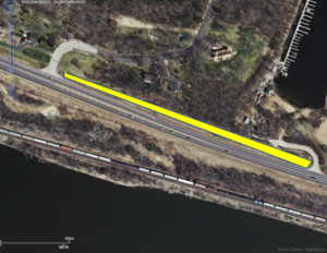
As part of a road reconstruction project, a swale with check dams will be constructed on permeable soils, thus allowing for infiltration. The underlying aquifer material is unknown, giving an Influence zone distance of 500 feet. In addition to the road, which is a major transportation route, land use within 500 feet of the swale consists of low density residential, a marina, and a railroad corridor. The site does not have known or past contamination. A site visit indicates there are fuel tanks at the marina and extensive soil staining along the railroad corridor. The fuel tanks are located 150 feet from the swale and, at their closest point, the stained soils are within 75 feet of the swale. Since the railroad has been in operation for several decades and because many different potential sources exist for the stained soils, it is difficult to obtain accurate information about the stained soils without field sampling. Rather than conduct soil sampling we assume the stained soils represent contaminated soil.
Using the County Geologic Atlas for the area, groundwater flow is determined to be toward the river. A mounding analysis is conducted using the USGS mounding calculator with the following inputs.
- Soils are sand and sandy loam for an infiltration rate of 0.8 inches per hour or 1.6 feet per day.
- The specific yield for a sand is 0.21
- The horizontal hydraulic conductivity is unknown so we assume the aquifer consists of gravel, giving a hydraulic conductivity of 283 feet per day.
- The swale is 1200 feet long by 20 feet wide. In the mounding calculator, the mound is calculated in the x direction, however, so we input a length of 10 feet (1/2 of the swale width) and a width of 600 feet (1/2 of the swale length).
- The drawdown time represents the duration of infiltration and is equal to 48 hours or 2 days
- The aquifer thickness is assumed to be 10 feet.
Using the mounding calculator, we are looking for the distance at which the mounded elevation is 0.25 feet. This is the height considered to be inconsequential for impacting groundwater flow. Using the information above, that distance is 120 feet. Since this is the distance from the center of the swale and we want the distance from the edge of the swale, we subtract 10 feet off this value, giving a distance of 110 feet. We multiply this by the safety factor of 2 to give a distance of 220 feet. This is greater than the distance to the stained soils (75 feet) so we choose not to infiltrate at this site because of the potential for mobilizing contaminants.
Note that contamination has not been confirmed through sampling. If the owner of the BMP wanted to continue pursuing infiltration at this site, a Phase 1 or Phase 2 investigation is highly recommended. Additional investigation would focus on soil and groundwater sampling in the railroad corridor. Alternatively, groundwater modeling could be conducted to determine if infiltrated stormwater would impact groundwater beneath the railroad corridor.
To see the checklist for this site, follow this link (File:Contamination screening checklist for stormwater infiltration.xlsx or File:Contamination screening checklist for stormwater infiltration July 2018.xlsx) and click on the worksheet called Example 3.
Example 4
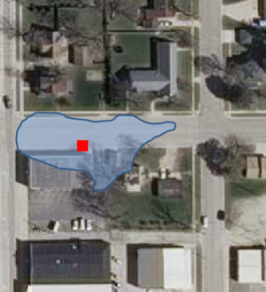
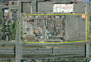
An infiltration BMP is proposed for a site located in a busy commercial area with major transportation corridors. The BMP is proposed for the northeast corner of the site, where there is no history of contamination. However, the western portion of the site is contaminated and has not been remediated. It is therefore appropriate to not infiltrate at this site.
If the owner of the BMP wants to continue pursuing infiltration at this site, a Phase 1 or Phase 2 investigation is highly recommended. This site poses significant risk of mobilizing contamination. In addition to existing known contamination, the nature of the area suggests a high potential for contaminated soils and groundwater. This includes numerous adjacent sites that have a history of contamination. There are also several features on the site that warrant concern, including considerable debris, monitoring wells, stained soils, odors, ponded water, and soil stockpiles.
To see the checklist for this site, follow this link (File:Contamination screening checklist for stormwater infiltration.xlsx or File:Contamination screening checklist for stormwater infiltration July 2018.xlsx) and click on the worksheet called Example 4.
What if I want to pursue infiltration even if my site may be contaminated?
The purpose of the screening guidance presented above was to identify sites where there is a reasonable likelihood that contaminants in soil and/or groundwater would be mobilized by infiltrated stormwater. The screening approach does not verify the presence of contamination and therefore represents a conservative approach to infiltrating stormwater.
The following discussion is aimed at individuals or entities who want to conduct additional site investigation to determine if infiltration is feasible at a site. It is recommended that a Phase 1 or Phase 2 environmental site assessment be conducted at this point.
Understanding the risks of infiltrating at a site that failed the above screening
The above screening assessment provides a qualitative analysis and identifies sites where a reasonable risk of mobilizing contaminants exists. There are sites that fail this screening where infiltration can still occur without mobilizing contamination. However, you must be aware of the risks associated with infiltrating at these sites.
- If high levels of contaminants are mobilized, you are in violation of the Construction Stormwater Permit.
- If contaminants are mobilized, you may associate yourself with a contaminant release, which can result in liability concerns.
Retaining a professional consultant
If you choose to continue pursuing infiltration at this point, a Phase 1 ESA is recommended. A qualified consultant should undertake and complete the investigation. Examples of qualified individuals include the following:
- hold a current Professional Engineer’s or Professional Geologist’s license or registration from a state, tribe, or U.S. territory and have the equivalent of 3 years of full-time relevant experience; or
- be licensed or certified by the federal government, a state, tribe, or U.S. territory to perform environmental inquiries and have the equivalent of 3 years of full-time relevant experience; or
- have a Baccalaureate or higher degree from an accredited institution of higher education in science or engineering and have the equivalent of 5 years of full-time relevant experience; or
- have the equivalent of 10 years of full-time relevant experience.
Phase 1 Environmental Site Assessment
If there is any reason to suspect soil or groundwater may be contaminated at a site, or if the current or recent land use is associated with activities involving potential contaminants, a Phase 1 ESA should be completed by a professional consultant. Industrial areas and areas where gas stations or dry cleaners are present are examples of areas where a Phase 1 ESA is recommended. The purpose of a Phase I ESA is to identify recognized environmental conditions that may exist on a site and assess whether any environmental impacts were likely present based on current and/or past on-site activities. Sources of information for determining site contamination are available from both the American Society for Testing and Materials (ASTM) and USEPA. These agencies provide information on the basics of performing Phase I Environmental Site Assessments (ESA). An ESA is conducted in accordance with the current ASTM Practice E 1527-13, Standard Practice for Environmental Site Assessments: Phase I Environmental Site Assessment Process, and 40 CFR Part 312, Standards and Practices for All Appropriate Inquiries.
A Phase I ESA involves collecting information similar to that for conducting a screening assessment, which is discussed in detail above.
Sources of information for Phase 1 ESA
The following sources may provide useful information in completing a Phase 1 ESA.
- U.S. EPA’s EnviroMapper and the MPCA’s What’s in My Neighborhood online tools to identify specific sites and locations of concern near the proposed infiltration site.
- The University of Minnesota John R. Borchert on line map directory provides online maps, including topographic maps and city maps.
- The Minnesota Historical Society holds more than 950 Sanborn Fire Insurance maps.
- The University of Minnesota provides historical aerial photos on-line.
- The State of Minnesota provides on-line access to assessor and property tax records.
If sources or potential sources of contamination are determined through a Phase I ESA, stormwater infiltration should not be considered unless a Phase II ESA is conducted.
Phase II Environmental Site Assessment
If sources or potential sources of contamination are determined through a Phase I ESA, stormwater infiltration should not be considered unless a Phase II ESA is conducted. During a Phase II Site Assessment, surface soil, subsurface soil, and groundwater samples are collected for laboratory analysis. The results should be compared to applicable standards to determine if the site needs to be classified as contaminated and/or reported in accordance with state regulations.
This section provides a summary and step-by-step process for conducting a Phase 2 ESA. Links to detailed information are included. A workplan should be prepared by a qualified professional. The workplan should include a detailed description of sampling methods, sampling equipment, sample analysis (including laboratory and field analysis), quality assurance procedures, a site safety and contingency plan, and a schedule. Because the purpose of this investigation is to determine if stormwater infiltration is feasible, the Phase 2 investigation only includes soil and groundwater sampling. However, if contamination is found at the site, other regulatory requirements may apply.
Determining sample analytes
Identifying potential contaminants of concern (COC) can save considerable cost associated with laboratory analysis. Different types of sites vary in their likely COCs. For more information, see here.
Soil sampling
The following procedure can be utilized for soil investigations.
- Determine the number and location of samples. Utilize a sampling grid if discrete sampling locations cannot be identified or if diffuse, area-wide contamination is likely.
- Obtain soil samples using appropriate equipment and methods. Conduct field analysis if appropriate (e.g. vapor samples for VOC contamination)
- Analyze samples (field or laboratory)
- Determine the extent and magnitude of contamination. This includes comparison with appropriate risk criteria to determine the likelihood of contaminants being transported at concentrations that represent a risk to human or ecological health. Additional sampling may be necessary at this point if the extent of contamination cannot be adequately determined.
Groundwater sampling
The following procedure can be utilized for groundwater investigations. Because of the expense involved in groundwater sampling, it is important to identify the source of contamination. Groundwater sampling should not be conducted until soil sampling has been completed at the site. Groundwater sampling may need to be completed in phases until the extent of any plume on the site can be defined. Consider temporary well samples and a geoprobe, which may provide better information at less cost.
- Determine depth to water and characterize the vertical profile through the vadose zone. This is important in determining the likelihood that contaminants will percolate through the vadose zone and into groundwater.
- Determine groundwater flow direction. This can be done with a geoprobe or using piezometers.
- Characterize the aquifer material (e.g. coarse sand, gravel). This is important for conducting a mounding analysis.
- Install monitoring wells.
- One to two weeks after monitoring wells are installed, properly develop the wells and then collect samples.
- Analyze samples (field or laboratory)
- Determine the extent and magnitude of contamination. This includes comparison with appropriate risk criteria to determine the likelihood of contaminants being transported at concentrations that represent a risk to human or ecological health. Additional sampling may be necessary at this point if the extent of contamination cannot be adequately determined.
Links to sampling and QA/QC guidance
- MPCA links
- Site characterization and sampling documents - General, comprehensive document for site remediation
- Underground Storage Tank and Petroleum Remediation Quality Assurance Program Plan - Petroleum guidance
- Spatial data collection at petroleum release sites - Petroleum guidance
- Excavation of petroleum-contaminated soil and tank removal sampling - Petroleum guidance
- Assessment of Petroleum Contamination at Closed Sites - Petroleum guidance
- Soil and groundwater assessments performed during site investigations - Petroleum guidance
- Vapor Intrusion Assessments Performed During Site Investigations - Petroleum guidance
- Assessment of Natural Attenuation at Petroleum Release Sites - Petroleum guidance
- Soil sample collection and analysis procedures (c-prp4-04) - Petroleum guidance
- Groundwater sample collection and analysis procedures (c-prp4-05) - Petroleum guidance
- Guidance Document #11 Phase II Investigation Work Plan - Brownfield guidance
- Other sites - note these guidance documents may include procedures not applicable to investigations in Minnesota
- Guidance for Cleaning Up Groundwater, Soil and Air at Corrective Action Facilities - U.S. EPA
- Remediation Technologies for Cleaning Up Contaminated Sites - U.S. EPA
- Arizona site investigation manual - see chapters 5, 6, and 7
- Guidance for Remediation of Petroleum Contaminated Sites - State of Washington; see Chapters 4, 5, 6, and 7
Supplemental Site Assessment
A Supplemental Site Assessment may be needed if pollutants detected during a Phase II are present at an unacceptable level. This level will be determined by local and federal regulations. The purpose of the supplemental site assessment is to determine the horizontal and vertical extent of the contamination. It is advisable to contact the MPCA for technical assistance before proceeding with a supplemental site assessment. Information on MPCA's role in providing technical assistance and liability assurances, including contact information, is described in this guidance document.
Liability issues
A concern with infiltrating stormwater through or into contaminated soils or groundwater is potential liability for a contaminant release. Minnesota statute 115B.03 defines the conditions under which a person may be associated with a release of a hazardous substance, pollutant, or contaminant from a facility. Specifically, "An owner of real property is not a person responsible for the release or threatened release of a hazardous substance from a facility in or on the property unless that person: ... (4) knew or reasonably should have known that a hazardous substance was located in or on the facility at the time right, title, or interest in the property was first acquired by the person and engaged in conduct associating that person with the release; or (5) took action which significantly contributed to the release after that person knew or reasonably should have known that a hazardous substance was located in or on the facility."
Thus, a person or party becomes liable only when a release occurs. In a case where a site investigation reveals the presence of contamination, but no release occurs, liability assurances can be given. These are explained in this guidance document. Specifically, the MPCA may provide No Association Determinations (NAD) or Off-site Source Determinations.
- A NAD is provided when the specific actions proposed by the voluntary party will not associate them with the identified contamination.
- An Off-site Source Determination is provided when groundwater contamination at a property originates from a source located on an adjacent or nearby property.
Each of these determinations is contingent on certain site conditions, which are described in detail in this guidance document.
Related pages
- Portal for Stormwater infiltration and contaminated soils and groundwater
- Contaminated sites and stormwater infiltration
- Stormwater Infiltration and soil/groundwater contamination: A guide to the Construction Stormwater Permit requirements
- Screening assessment for contamination at potential stormwater infiltration sites
- Stormwater infiltration guidance for sites with known or high potential for soil or groundwater contamination on or off-site
- Links to Minnesota Pollution Control Agency cleanup and remediation information
- Case studies for stormwater infiltration at contaminated sites
- Links to information and guidance on stormwater infiltration at contaminated sites
- References for stormwater infiltration at contaminated sites


