Difference between revisions of "Soil erodibility"
| (3 intermediate revisions by the same user not shown) | |||
| Line 29: | Line 29: | ||
*[https://www.ars.usda.gov/ARSUserFiles/50201000/USLEDatabase/AH_537.pdf Predicting Rainfall Erosion Losses] | *[https://www.ars.usda.gov/ARSUserFiles/50201000/USLEDatabase/AH_537.pdf Predicting Rainfall Erosion Losses] | ||
*[https://www.ars.usda.gov/midwest-area/west-lafayette-in/national-soil-erosion-research/docs/usle-database/research/ About the Universal Soil Loss Equation] - National Soil Erosion Research: West Lafayette, IN | *[https://www.ars.usda.gov/midwest-area/west-lafayette-in/national-soil-erosion-research/docs/usle-database/research/ About the Universal Soil Loss Equation] - National Soil Erosion Research: West Lafayette, IN | ||
| − | *[https:// | + | *[https://fargo.nserl.purdue.edu/rusle2_dataweb/RUSLE2_Index.htm Revised Universal Soil Loss Equation - Version 2] |
*[https://www.sciencedirect.com/topics/earth-and-planetary-sciences/revised-universal-soil-loss-equation Revised Universal Soil Loss Equation] | *[https://www.sciencedirect.com/topics/earth-and-planetary-sciences/revised-universal-soil-loss-equation Revised Universal Soil Loss Equation] | ||
| Line 45: | Line 45: | ||
[[File:Soil structure 2.jpg|300px|thumb|alt=image soil structure|<font size=3>Types of soil structure</font size>]] | [[File:Soil structure 2.jpg|300px|thumb|alt=image soil structure|<font size=3>Types of soil structure</font size>]] | ||
| − | *Use [https://websoilsurvey.nrcs.usda.gov/app/ NRCS Soil mapping tool] in advance of site visit | + | *Use [https://websoilsurvey.nrcs.usda.gov/app/ NRCS Soil mapping tool] in advance of site visit. |
*Determine the most erodible soil at a site. Soils with silt and fine or very fine sand are highly erodible. [https://www.youtube.com/watch?v=fufeaLBLGlk See this Youtube]. | *Determine the most erodible soil at a site. Soils with silt and fine or very fine sand are highly erodible. [https://www.youtube.com/watch?v=fufeaLBLGlk See this Youtube]. | ||
*Identify the <span title="Soil structure describes the arrangement of the solid parts of the soil and of the pore space located between them. It is determined by how individual soil granules clump, bind together, and aggregate, resulting in the arrangement of soil pores between them."> '''soil structure'''</span>. General erodibility is Platy > Massive > Blocky > Aggregated. You likely will not encounter columnar structure. Granular structure varies. Fine and very <span title="soil with a diameter of 0.063 mm to 0.2 mm"> '''fine sands'''</span> are granular but highly erosive, while medium to coarse sands are less erosive. Certain practices at a site may change the structure, especially soils with appreciable amounts of clay. See adjacent image. | *Identify the <span title="Soil structure describes the arrangement of the solid parts of the soil and of the pore space located between them. It is determined by how individual soil granules clump, bind together, and aggregate, resulting in the arrangement of soil pores between them."> '''soil structure'''</span>. General erodibility is Platy > Massive > Blocky > Aggregated. You likely will not encounter columnar structure. Granular structure varies. Fine and very <span title="soil with a diameter of 0.063 mm to 0.2 mm"> '''fine sands'''</span> are granular but highly erosive, while medium to coarse sands are less erosive. Certain practices at a site may change the structure, especially soils with appreciable amounts of clay. See adjacent image. | ||
| Line 54: | Line 54: | ||
==Suggested references and links== | ==Suggested references and links== | ||
*[https://stormwater.pca.state.mn.us/index.php?title=General_principles_for_erosion_prevention_and_sediment_control_at_construction_sites_in_Minnesota Soil Erodibility On Construction Areas] | *[https://stormwater.pca.state.mn.us/index.php?title=General_principles_for_erosion_prevention_and_sediment_control_at_construction_sites_in_Minnesota Soil Erodibility On Construction Areas] | ||
| − | *[https://dnr.wi.gov/ | + | *[https://dnr.wi.gov/topic/stormWater/documents/constructionSiteSoilLossSedimentDischarge.pdf Wisconsin Construction Site Soil Loss and Sediment Discharge Calculation Guidance] |
*[https://stormwater.pca.state.mn.us/index.php?title=Soils_and_geology Soil surveys and other resources] | *[https://stormwater.pca.state.mn.us/index.php?title=Soils_and_geology Soil surveys and other resources] | ||
| − | *[https://dec.vermont.gov/ | + | *[https://dec.vermont.gov/watershed/stormwater/permit-information-applications-fees/stormwater-construction-discharge-permits Vermont Soil Erodibility Evaluation for General Permit 3-9020 Stormwater Runoff From Construction Activities] |
*[https://mepas.pnnl.gov/mepas/formulations/source_term/5_0/5_32/5_32.html#targetText=The%20soil%20erodibility%20factor%20(K,transport%20by%20rainfall%20and%20runoff. Soil erodibility factor] | *[https://mepas.pnnl.gov/mepas/formulations/source_term/5_0/5_32/5_32.html#targetText=The%20soil%20erodibility%20factor%20(K,transport%20by%20rainfall%20and%20runoff. Soil erodibility factor] | ||
*[[General principles for erosion prevention and sediment control at construction sites in Minnesota]] | *[[General principles for erosion prevention and sediment control at construction sites in Minnesota]] | ||
| Line 63: | Line 63: | ||
<noinclude> | <noinclude> | ||
| + | |||
==Related links== | ==Related links== | ||
*Soil concepts | *Soil concepts | ||
| Line 81: | Line 82: | ||
**[[Sediment control practices]] | **[[Sediment control practices]] | ||
| − | [[Category: | + | [[Category:Level 2 - Technical and specific topic information/soils and media]] |
</noinclude> | </noinclude> | ||
Latest revision as of 17:53, 30 January 2023
Erodibility describes or is a measure of the inherent resistance of geologic materials (soils and rocks) to erosion. Highly erodible geologic materials are readily displaced and transported by water. This page provides basic information about soil erodibility.
Contents
Types of soil erosion
There are four types of soil erosion.
- Sheet erosion: the uniform removal of soil in thin layers by the forces of raindrops and overland flow. It can be a very effective erosive process because it can cover large areas of sloping land and go unnoticed for quite some time (National Soil Erosion Research Laboratory).
- Rill erosion: the removal of soil by concentrated water running through little streamlets, or headcuts. Detachment in a rill occurs if the sediment in the flow is below the amount the load can transport and if the flow exceeds the soil's resistance to detachment (National Soil Erosion Research Laboratory).
- Gully erosion: the removal of soil along drainage lines by surface water runoff. Once started, gullies will continue to move by headward erosion or by slumping of the side walls unless steps are taken to stabilise the disturbance (Agriculture Victoria).
- Dispersive soils: dispersive soils are structurally unstable, which makes them vulnerable to the forms of erosion described above. Dispersive soils are typically clay soils with an exchangeable sodium percent greater than 5%.
Calculating soil loss - Universal Soil Loss Equation
The Universal Soil Loss Equation (USLE) and it's update, the Revised Universal Soil Loss Equation (RUSLE) are used to predict sheet and rill erosion. These equations do not apply to gully erosion and dispersive soils. The annual soil loss, in tons per acre, is given by the following formula.
Annual soil loss = R * K * LS * C * P
where
- R = rainfall erosivity factor
- K = soil erodibility factor
- LS = slope length and gradient factor
- C = cover management factor
- P = erosion control practice factor
RUSLE factors are observable in the field and fairly simple to derive. The R and K variables are generally out of the hands of the construction site operator. Slope (S) and slope length (L) can sometimes be managed or impacted during the design phase of project development. Two RUSLE variables which can be controlled at active construction sites – the cover and practices factors (i.e., variables C and P) – are the focus of the erosion prevention measures. Erosion prevention practices, which mostly include soil preparation, vegetation, and the application of a mulch, blanket, mat, or other cover on bare soil, are the easiest, cheapest, and most effective approach for addressing runoff from construction sites. Sediment control – settling soil particles from temporarily ponded runoff water or filtering it using silt fencing or other materials – is more difficult, more expensive, and requires much more maintenance.
For more information on the USLE and RUSLE, see the following.
- Predicting Rainfall Erosion Losses
- About the Universal Soil Loss Equation - National Soil Erosion Research: West Lafayette, IN
- Revised Universal Soil Loss Equation - Version 2
- Revised Universal Soil Loss Equation
Soil erodibilty
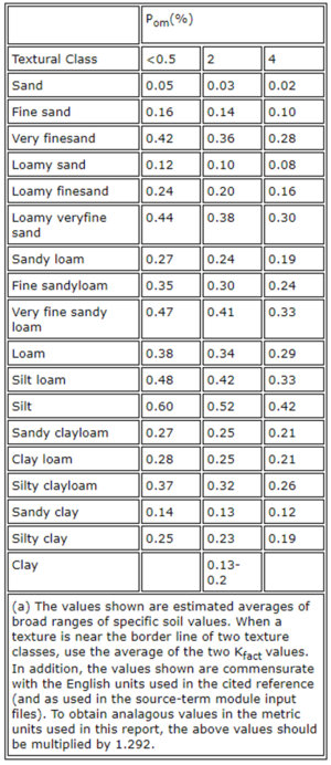
Soil erodibility ( K ) is the intrinsic susceptibility of a soil to erosion by runoff and raindrop impact. In general, the following affect K. See adjacent table.
- Increasing amounts of soil organic matter result in decreasing values of K
- Soil type effect on K: silt > silt loam = fine sand > loam > clay loam > clay > coarse sand. Note that wet clay soils that have expanded have increased risk.
- Coarse sand particles are too large to transport
- Clays are cohesive with good soil structure and it is difficult to dislodge soil particles
- Silts and fine sands are not cohesive and are easily transported
- Texture is the principal factor affecting Kfact, but structure, organic matter, and permeability also contribute
- The soil erodibility factor ranges in value from 0.02 to 0.69
Tools for assessing soil erodibility at construction sites
- Use NRCS Soil mapping tool in advance of site visit.
- Determine the most erodible soil at a site. Soils with silt and fine or very fine sand are highly erodible. See this Youtube.
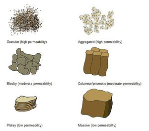
- Identify the soil structure. General erodibility is Platy > Massive > Blocky > Aggregated. You likely will not encounter columnar structure. Granular structure varies. Fine and very fine sands are granular but highly erosive, while medium to coarse sands are less erosive. Certain practices at a site may change the structure, especially soils with appreciable amounts of clay. See adjacent image.
- Examine the soil for organic matter content. Organic matter imparts a black color to soil. Organic matter binds soil and reduces the risk of erosion.
- If subsoils are exposed, this might increase erodibility since subsoils generally lack organic matter and disturbance may destroy the soil structure.
- Determine if rills and gullies are starting to form. These can lead to significant soil losses.
Suggested references and links
- Soil Erodibility On Construction Areas
- Wisconsin Construction Site Soil Loss and Sediment Discharge Calculation Guidance
- Soil surveys and other resources
- Vermont Soil Erodibility Evaluation for General Permit 3-9020 Stormwater Runoff From Construction Activities
- Soil erodibility factor
- General principles for erosion prevention and sediment control at construction sites in Minnesota
- Erosion prevention practices
- Sediment control practices
Related links
- Soil concepts
- Soil properties
- Determining soil infiltration
- Soil management
This page was last edited on 30 January 2023, at 17:53.


