![]()
Aaron test

Practices to consider
|
| Cities or other local units of government may have ordinances or regulations that promote or hinder implementation of practices that improve climate resilience. For example, tree preservation and replacement ordinances promote resilience, while restrictions on infiltration may hinder resilience. |
In Minnesota, climate trends show that conditions across the state are becoming warmer and wetter. Over the last 25 years, Minnesota’s annual average precipitation has increased by 3.4 inches and temperatures have warmed by 3.0°F (MN DNR, n.d.). With more rain becoming the norm and rain intensity increasing, the frequency and severity of local flooding are increasing as well (MPCA, n.d.). At the same time, summer droughts are also projected to get worse, partly due to increases in temperature (States at Risk, 2015) and longer dry times between rain events. These climate change trends present unique challenges to urban stormwater management systems that were historically not designed for these types of rain patterns.
Green stormwater infrastructure is one tool communities can use to mitigate and adapt to a changing climate and bolster a community’s resilience. Standard design practices for GSI can be modified or enhanced to better mitigate and adapt to climate change. These design mechanisms and practices include, but are not limited to:
- Planning GSI systems for climate change
- Enhancing infiltration and detention
- Enhancing interception and evapotranspiration
- Selecting climate resilient vegetation
- Preserving natural areas
- Enhancing harvest and reuse,
- Combining gray infrastructure and green practices
- Sequencing GSI in treatment trains, and
- Implementing real-time controls (dynamic design)
Each of these are explained in more detail in the sections below.
Contents
- 1 Planning GSI systems for climate change
- 2 Preserving Natural Areas
- 3 Enhancing Infiltration and Detention
- 4 Enhancing interception and evapotranspiration
- 5 Selecting climate resilient vegetation
- 6 Enhancing Harvest and Reuse
- 7 Combining grey and green practices
- 8 Sequencing GSI in treatment trains
- 9 Implementing real-time controls (Dynamic Design)
- 10 References
- 11 Image References
Planning GSI systems for climate change


Effective GSI climate change design strategies begin during the planning stage of GSI. Local climate change trends and hazards should be identified early in the planning stage to effectively design GSI that can withstand and mitigate the added stress brought about by climate change. The Planning GSI Projects and Practices section of the MN Stormwater Manual includes useful guidance for planners and practitioners who want to implement GSI. Some key questions to ask include:
- How will precipitation patterns change? Over the last 25 years, Minnesota’s annual average precipitation has increased by 3.4 inches (MN DNR, n.d.), but local trends can be different. The time between precipitation events is also changing, which can lead to drought conditions.
- How will freezing and thawing patterns change? Thawing may bring unseasonably high runoff volumes to GSI during the winter as snowmelt occurs due to fluctuating temperatures during the winter months.
- How will temperatures change? Certain plant species may not tolerate warmer temperatures.
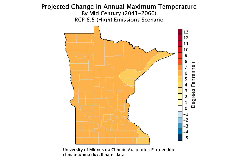
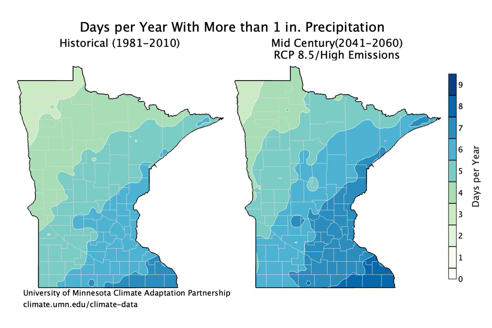
Planning for GSI systems can be informed by an understanding of future climate change projections as well as an understanding of past severe weather events. The Minnesota Department of Natural Resources has developed a Minnesota Climate Trends Tools that compiles and displays historic precipitation, temperature, and drought severity index data to understand temporal trends in each of the Minnesota watersheds. This tool is helpful in identifying past severe events and understanding current trends in the data. The University of Minnesota used statistical downscaling to project changes to Minnesota’s climate at the end of the century (2100) and published a variety of maps (shown below) showing projected changes to precipitation and temperature. The NOAA Atlas 14 Intensity-Duration-Frequency Curves, which are often used in engineering guidance, are currently being updated to incorporate climate change and are expected to be published in December of 2023. Other guidance is also available to update these curves based on climate change projections to update these curves (Batalini de Macedo et al., 2022).
Hydrologic and hydraulic (H&H) modeling of GSI can also help plan and design GSI for future climate change conditions. Most GSI model applications can effectively simulate conditions under different climate change precipitation and temperature projections. Precipitation and temperature projections are readily available from Global Climate Models, but these are often too coarse to apply at the local level. However, Maimone et al. (2019) provides guidance on scaling the Global Climate Model precipitation data to hourly and sub-hourly timeseries for local H&H model input. Note that temperature projections are sensitive to emission scenarios, so consideration should be given to which (and how many) emission scenarios to include in a modeling exercise. Several studies (Batalini de Macedo et al., 2022; De Paola et al., 2015; Madsen et al., 2014; Wang et al., 2013) recommend updating Intensity-Duration-Frequency precipitation curves to develop design storms under future climate change conditions. Additionally, it may also be appropriate to use historic extreme events in a model since these provide insight into the response of the local landscape and GSI to actual rainfall. When modeling future scenarios under climate change, also consider land use changes such as urbanization, since these often go hand-in-hand with climate change. Accounting for land use changes will increase peak flows and runoff volumes and add additional stress to GSI beyond that caused by climate change.

Some research examples of H&H models that include climate change considerations include:
- Researchers at Carnegie Mellon University assessed the performance of GI in response to changing precipitation patterns, and the accuracy of their performance predictions were evaluated in Pittsburgh and Memphis (Cook, 2021).
- Researchers at the South China University of Technology applied the Storm Water Management Model (SWMM) to assess the runoff and water quality control effect of GI under different climate change scenarios (Zeng, 2021).
- Researchers at TetraTech and EPA applied the Regional Hydro-Ecologic Simulation System (RHESSys), to investigate the sensitivity of different GI practices to climate change and the performance of GI practices for water quantity, water quality, and carbon sequestration (Sarkar, 2018).
Additional Resources and Guidance:
- Climate Ready DC Resilient Design Guidelines (DOEE): https://doee.dc.gov/sites/default/files/dc/sites/ddoe/service_content/attachments/CRDC%20resilient%20design%20guidelines_FINALApproved.pdf
- Climate-Resilient Planning and Design Guidance (Philadelphia Water Department): https://water.phila.gov/pool/files/climate-resilient-guidance.pdf
- Resource Guide for Planning, Designing, and Implementing Green Infrastructure in Parks: https://www.nrpa.org/siteassets/gupc-resource-guide.pdf
Preserving Natural Areas

Protecting and preserving natural areas from development is one of the most effective ways to mitigate future climate change. Preserved land can protect nearby neighborhoods from heavy rain and potential flooding, protect water quality, sequester carbon, reduce surrounding air temperature, and provide ecological habitat. The benefits of preserving natural areas are unrivaled compared to the benefits of any other GSI system. Communities can be selective in preserving natural areas, prioritizing, for example, natural areas around water bodies or creating continuous corridors of natural areas rather than stand-alone pockets. Preserving existing trees is an important component of preserving natural areas. Mature trees have a more expansive canopy cover and root network than saplings or young trees, so they are capable of providing greater shade, interception, evapotranspiration, and infiltration benefits and do not require the potentially lengthy maturation period that new plantings would require. Natural areas can also be used as means of connecting GSI through continuous corridors to design an interconnected, treatment train approach to stormwater treatment as well as to allow for connectivity of species and ecological processes through the GSI system (Snäll et al., 2016).
Many cities have established regulations and ordinances that require the preservation of natural areas. Some examples include:
- Maplewood, MN’s wetland ordinances (Code 1982, § 9-196; Ord. No. 848, § 1; Ord. No. 895, §§ 1—9; Ord. No. 928, §§ 1—9; Ord. No. 962, § 4) protect native or naturalized wetlands, streams, and buffers from being converted into lawn area.
- Lakeville, MN’s tree preservation ordinance (Ord. No. 673, §1) requires the submittal of a tree preservation plan to preserve as many significant trees as possible during development. If any tree listed as ‘save’ in the plan is destroyed, it must be replaced with two trees.
- Fairfax County, VA’s Chesapeake Bay Preservation Ordinance (Chapter 118) designates environmentally sensitive areas that lie alongside or near the shorelines of streams, rivers and other waterways as Resource Protection Areas (RPAs). Development, uses, and activities within RPAs are regulated.
- Cheltenham Township, PA’s site planning ordinance (§ 280-9) requires protection of viable trees in wooded lots, restricts grading from resulting in the removal of more than 50% of the site’s vegetation, and preservation of vegetation which provides wildlife food and cover or serves as a visual amenity.
- New York City, NY’s Special Natural Area District Resolution aims to preserve natural features with ecological and conservation values and function and protect natural features in areas of outstanding natural beauty.
Case Studies:
- Graco Park green infrastructure and habitat restoration https://www.mwmo.org/projects/graco-park-green-infrastructure/
- Journal article by Girault (2017): Between naturalness and urbanity, how are protected areas integrated into cities? The case of Helsinki (Finland) https://journals.openedition.org/articulo/3270
Additional Resources:
- Conservation Tools developed by WeConservePA summarizes useful land conservation resources: https://conservationtools.org/
Enhancing Infiltration and Detention
Infiltration based GSI such as bioretention can reduce the impact of localized inland flooding by providing storage and infiltration of rainfall and stormwater that would otherwise overwhelm sewer and drainage systems, including small streams. Infiltration based GSI can also help mitigate the impacts of drought by enhancing groundwater recharge as well as help improve local water quality through natural processes associated with infiltration such as filtration, settling, and biological uptake of some pollutants. Enhancing the infiltration potential of GSI can be an important design criterion when designing climate resilient infiltration based GSI. The primary mechanisms to enhance infiltration include:
- Improving the soil/media of the GSI
- Decompacting the GSI soil
- Establishing healthy vegetation
- Increasing the storage volume of the GSI
These techniques can increase the rate of infiltration (i.e., how fast stormwater can infiltrate into the GSI) and improve the overall capacity for infiltration (i.e., how much stormwater can infiltrate into the GSI). Enhancing a GSI’s detention time can also help mitigate climate change impacts such as downstream localized flooding by storing more water upstream for a longer period and, in the case of infiltration based GSI, by providing more time for water to infiltrate. The primary mechanisms to enhance detention include increasing the GSI storage volume and increasing the residence time of the system, both of which can also enhance infiltration.
The various mechanisms for enhancing infiltration and detention are explained in more detail below.
Soil/Media improvements
Soil and media improvements can be made through amendment with organic matter which promotes a healthy soil matrix and enhances infiltration (USDA, 2008). This is particularly helpful for soils that are compacted or consist largely of clay soil. Amendments should be added to the entire GSI rather than just the planting holes. Amendments can be incorporated throughout the GSI media using tillage equipment (USDA FS, 2020). If nutrients are a local water quality concern and the GSI is designed to be a filtration practice, avoid amendments with high phosphorus or nitrogen content as these can leach from the soil to surface water causing undesirable impacts like algal growth. If the GSI is designed to be an infiltration practice, then nutrient leaching may not be a concern. Biochar is a soil amendment that is gaining traction in the stormwater community for use in green infrastructure to improve filtration. Note that the benefits obtained from the amendment will diminish over time as the organic matter is broken down and consumed. It is, therefore, advised to incorporate other infiltration enhancement techniques such as decompaction and diverse deep-root vegetation to create lasting infiltration benefits.
Additional resources and guidance:
- Soils with low infiltration capacity (MPCA): https://stormwater.pca.state.mn.us/index.php/Soils_with_low_infiltration_capacity
- Design Infiltration Rates (MPCA): https://stormwater.pca.state.mn.us/index.php?title=Design_infiltration_rates
- Soil amendments to enhance phosphorus sorption (MPCA): https://stormwater.pca.state.mn.us/index.php?title=Soil_amendments_to_enhance_phosphorus_sorption&oldid=30950
- Soil Amendment Guidance for Infiltration and Stormwater Treatment (CalTrans): https://dot.ca.gov/-/media/dot-media/programs/research-innovation-system-information/documents/preliminary-investigations/soil-amendment-guidance-for-infiltration-stormwater-treatment-pi-a11y.pdf
- Applications for biochar in stormwater management (MPCA): https://stormwater.pca.state.mn.us/index.php?title=Biochar_and_applications_of_biochar_in_stormwater_management#Applications_for_biochar_in_stormwater_management
Soil decompaction

Soil compaction is common in urban environments and can reduce infiltration rates by as much as 70 to 99 percent (Gregory, 2006). Decompaction techniques can be used to break up dense, compacted soil. Both shallow (<18”) and deep soil decompaction (>18”) techniques exist. Deep soil decompaction will allow for roots, microbes, fungi, etc. to spread deeper into the soil, which enhances the soil structure and increases infiltration. Accompanying decompaction with soil/media amendments also allows for more rapid vegetation establishment and better infiltration (USDA FS, 2020; Schwartz, 2021). Note that the effectiveness of decompaction depends on the soil moisture. Soil that is too dry is at risk of pulverization by decompaction which could create fine sediment that is likely to recompact during rain events (USDA FS, 2020), while decompaction on soils that are too wet will not break up the soil effectively (Natural Resources Canada, 2018).
Additional resources and guidance:
- A guide to Soil Decompaction (Natural Resources Canada): http://www.cif-ifc.org/wp-content/uploads/2018/03/4_17-0006-Soil-Decompaction-EN_nov_29_acc-1.pdf
- The Effectiveness of Soil Decompaction for Stormwater Management (MD DOT): https://www.roads.maryland.gov/OPR_Research/MD-21-SHAUMBC2-01_Soil-Decompaction_Report.pdf
- A guide to successful subsoiling (CETAB): https://cetab.bio/system/files/publications/weill_2015._guide_to_successful_subsoiling._cetab.pdf
- Alleviating Compaction from Construction Activities (MPCA): https://stormwater.pca.state.mn.us/index.php/Alleviating_compaction_from_construction_activities
Establish Healthy Vegetation
Establishing healthy vegetation in GSI is a key component to enhancing infiltration and detention in GSI. Infiltration can be enhanced by the active roots creating macropores through which water can infiltrate and by dead roots providing organic matter to the soil and improving the integrity of the soil matrix. Deep rooted vegetation can be particularly favorable to infiltration. Certain grasses, shrubs, rushes, and forbs are among the plants that can have deep roots. Prairie species particularly, which have adapted and developed to recover from fires and other events, tend to have deep roots. These species may be sensitive to shading and, if planted beneath larger shrubs or trees, their growth may be inhibited (Shaw and Schmidt, 2003). A USGS study found that the median infiltration rate of clay soil planted with prairie species was more than three times the rate of clay soil planted in turf (0.88 vs 0.28 inches/hour) (Selbig, 2010). Additionally, leafy vegetation can shelter the soil beneath it by dissipating some of the energy of rain drops before they reach the soil surface and preventing crust formation (i.e., the formation of a compacted, poorly infiltrative layer at the top of the soil surface) on bare soil (Alizadehtazi et al., 2019).
Vegetation can also enhance the detention capacity by removing water from the GSI through uptake and evapotranspiration, thereby emptying the GSI and regenerating the storage volume between rain events. Incorporating vegetation with high evapotranspiration rates into the GSI increases the removal rate and detention of runoff (GSA, 2011). In the case of retention practices, which are functionally similar to detention practices with the exception that the water is stored permanently, performance is driven more strongly by evapotranspiration rather than the GSI’s overall storage capacity, further emphasizing the importance of incorporating vegetation with high evapotranspiration rates into the GSI design (Johannessen et al., 2018).

See the Selecting Climate Resilient Vegetation section below for more vegetation guidance.
GSI Storage Volume Sizing

Both infiltration and detention can be enhanced by increasing the storage capacity of the GSI. Increasing the storage capacity (i.e., making the GSI bigger) allows for more water to enter and be stored in the GSI, and depending on the surface area of the GSI, can also promote more diffuse infiltration into the surrounding soil.
Historical and future projections of rainfall data can help determine how much bigger to make GSI. For example, if GSI are designed to retain the 90th percentile of rainfall, future rainfall projections may show that the 90th percentile of rain may be more in the future compared to twenty years ago. For GSI with limited area, as is common in urban landscapes, vertical walls provide greater surface storage capacity than graded edges (see Figure 2 ). Figure 7 a) Bioretention cell with vertical walls. (Source: NACTO, n.d. (1)) b) Bioretention cell with graded walls. (Source: adapted from NACTO, n.d. (2))
Subsurface storage can be increased by increasing the dimensions (depth, width, length) of the GSI or by selecting media with higher void space. In areas with poor infiltrating native soils, underdrains are often required. While typical underdrains themselves do not add additional storage to GSI, they can be used to convey water from the GSI to the storm sewer system, reducing the risk of GSI flooding and allowing for more rapid draining of the GSI. However, underdrains can be strategically designed to increase subsurface storage by elevating the underdrain connection to the storm sewer network using two 90-degree elbows as shown in Figure 3. This technique allows for the formation of an internal water storage layer in GSI with an underdrain. In high infiltration soils, this design can result in substantial outflow reduction due to increased infiltration; therefore, the upturned elbow underdrain design may not only provide subsurface storage benefits but also infiltration benefits (Brown, Hunt, & Kennedy, 2009).
Additional Resources and Guidance:
- Bioretention Cell Sizing (NACTO): https://nacto.org/publication/urban-street-stormwater-guide/stormwater-elements/bioretention-design-considerations/bioretention-cell-sizing/
- Infiltration design guideline – underdrains (MPCA): https://stormwater.pca.state.mn.us/index.php?title=Infiltration_design_guideline_-_underdrains
Increasing Residence Time

Increasing the hydraulic residence time slows the rate of export of stormwater from the GSI and increases the detention time of water in the GSI. Residence time can be increased by lengthening the flow path between where water enters and leaves the GSI; by reducing the slope along the flow path; by installing small check dams, and, if using an underdrain, by reducing the size of the underdrain orifice. In tightly packed urban areas where there is not room to lengthen the flow path or expand the area of the GSI, increasing the GSI depth can be a meaningful way of increasing both the storage capacity and increasing the residence time. Residence time can also be increased by incorporating media with mixed particle size distribution that are packed more tightly, which will slow the rate of transport through the soil; however, this will also lower the infiltration rate, which may be undesirable depending on the design criteria for the GSI (GSA, 2011).
Case Studies:
- International Plaza Drive improvements, City of St. Ann, Missouri: https://stormwater.pca.state.mn.us/index.php?title=Case_studies_for_dry_swale_(grass_swale)
- Use of check dams on the 1201 Metropolitan Avenue blue roof in New York City. See page 42: https://www.nyc.gov/assets/dep/downloads/pdf/water/stormwater/green-infrastructure/gi-annual-report-2011.pdf
Regulatory Incentive Mechanisms
City and State stormwater regulations have the potential to either limit or promote infiltration activities. For example, the Minnesota Construction Stormwater General Permit prohibits construction of infiltration systems in areas where type D soils (low infiltration, clay soils) are dominant or where infiltration rates are greater than 8.3 inches/hour (MPCA, 2022). Regulatory agencies should consider re-evaluating permits to encourage infiltration and maintain protections against local flooding. Regulatory incentive mechanisms that can be used to promote infiltration include:
- Encourage maximizing infiltration.
- Allow credit for infiltration volume beyond the 1” volume requirement in the Minnesota permit which can then be sold or used on another project.
- Allow infiltration on poorly infiltrating soils by adding underdrains or amendments.
- For businesses and property owners who reduce the quantity of stormwater runoff from their property through infiltration, offer credits that can be used to reduce their stormwater utility bill (see an example of this in the of Springfield, OH).
See the EPA Municipal Handbook: Incentive Mechanisms for a detailed description of incentives offered by municipalities in the United States that promote the use of GSI, including infiltration based GSI It should be noted that while infiltration should be maximized, restrictions should exist to prevent adverse impacts to the system such as flooding.
Enhancing interception and evapotranspiration
Enhancing interception and evapotranspiration through targeted plant and tree selection can allow more stormwater to be treated by the GSI by intercepting rainwater before it reaches the GSI or by uptake of the water in the GSI by the vegetation, thereby draining the GSI faster than through infiltration or underdrains alone.
Plants and trees with larger leaf surface areas provide greater opportunity for interception. Further, trees with more rigid and rough surfaced leaves have greater interception potential compared to flexible and smooth-surfaced leaves (Xiao and McPherson, 2016). This applies to bark as well: stemflow, or rainfall reaching the ground by conveyance down tree bark, decreases with increasing bark roughness (Barbier et al., 2009). This results in lower throughfall rates for rough-barked trees compared to smooth-barked trees (Beidokhti & Moore, 2021). Table 1 below shows interception rates for numerous mature coniferous and deciduous tree species. Interception by trees can also be estimated using models (Gómez et al., 2001 and Xiao et al., 2000)
In addition to enhanced interception, tree selection can also target species that have enhanced evapotranspiration capabilities. Tree xylem structure is one feature that can influence evapotranspiration since water is transported through the tree by xylem. Trees with deep sapwood and diffuse-porous xylem (e.g., birch and maple trees) have been shown to evapotranspire greater volumes of water than shallow sapwood species with ring-porous, semi-ring-porous, or tracheid xylem such as oak and conifers (USDA FS, 2020).
Understory plants (i.e., plants under the tree canopy) can also support interception and evapotranspiration. Consider selection of shade-, heat-, and salt- tolerant vegetation to better prepare for climate change.
Interception rate for various tree species
Link to this table
| Tree type | Tree name | Percent interception | Reference |
|---|---|---|---|
| Coniferous | Red cedar | 76 | Huang et al (2017) |
| Douglas fir | 69 | Huang et al (2017) | |
| Red cedar | 61 | Asadian & Weiler (2009) | |
| Douglas fir | 49 | Asadian & Weiler (2009) | |
| Black pine | 47 | Zabret & Srag (2019) | |
| White pine | 43 | Hathaway (2019) | |
| Deciduous | White peppermint | 44 | Livesley et al (2013) |
| Gingko | 38 | Xiao & McPherson (2011) | |
| Red maple | 29 | Hathaway (2019) | |
| Willow oak | 29 | Hathaway (2019) | |
| Blue gum | 29 | Livesley et al (2013) | |
| Silver birch | 24 | Zabret & Sraj (2019) | |
| Sweetgum | 14 | Xiao & McPherson (2011) |
See the Selecting Climate Resilient Vegetation section below for more vegetation guidance.
Selecting climate resilient vegetation
While native plants are the best choice for a GSI plant palette, it is important to choose the natives that are appropriate for the site’s particular conditions. Considerations include:
|
Vegetation helps enhance GSI functions like infiltration, interception, and evapotranspiration and can make GSI more resilient to climate change impacts such as increased rain, longer dry spells, or warmer temperatures. Vegetation that is native, climate change tolerant, and, if needed, salt tolerant, can help GSI function better and longer in the face of climate change impacts.
Native plants typically are better adapted to local conditions and have a natural resiliency to the variations in climate of the region where they are native. This makes them naturally more resilient to long term changes in climate change too. Additionally, native vegetation provides ecological benefits for local wildlife (ASLA, n.d.).
The Minnesota Department of Natural Resources’ Native Plant Encyclopedia includes detailed information on native plants in Minnesota and the US Department of Agriculture Agricultural Research Service’s Plant Hardiness Zone Map identifies the plant types that are likely to thrive in different regions across Minnesota. Selection of native vegetation for GSI should include consideration for the local site conditions (e.g., soil type, amount of sunlight received, periods of drought, or standing water at the site). For instance, if the GSI will be holding water for an extended time, it is essential that the native plants can tolerate wet conditions while also potentially withstanding periods of drought. It is also important to incorporate a diverse palette (e.g., grouping of plants appropriate for certain site or environmental conditions) to reduce the risk of vegetation loss from plant diseases or insect infestations. The Minnesota Board of Water and Soil Resources has guidelines on native vegetation establishment and enhancement that provides useful information in the selection, growing, and maintenance of native vegetation in Minnesota (MN BWSR, 2019).
Native plants often produce extensive root structures that assist in creating a complex and diverse soil structure which promotes infiltration and a healthy soil structure. If selecting vegetation to increase infiltration, design a plant palette with a diversity in plant roots. Shallow-rooted vegetation typically establish quickly but deep-rooted and slower-growing vegetation such as trees will over time develop extensive root networks and should also be considered for selection. In fact, trees have been shown to increase infiltration at a young age (Bartens et al., 2008).
To select vegetation for climate resilience, consider future rainfall, temperature, and drought potential. See the Climate Adapted Urban Trees List from the MN Department of Natural Resources for a breakdown of trees suitable to several climate change conditions (e.g., increased temperatures, more frequent drought). Incorporate drought-tolerant plants that will survive long dry spells once established (typically after the first growing season).
Additionally, consider salt-tolerance when selecting vegetation for GSI particularly when designing GSI near roads and paths that are likely to receive salt application in the winter. Salt reduces a root’s ability to absorb water, and the sodium in road salt can attach to the soil particle and increase soil density and compaction which has negative infiltrative results (Gould, 2013). Refer to the Minnesota stormwater manual “Salt Tolerant Plants” page for lists of salt tolerant vegetation (including trees) as well as recommended salt tolerant mixes.
Additional Resources and Guidance:
- A Design Manual: Engineering With Nature Using Native Plant Communities (USACE ERDC): https://ewn.erdc.dren.mil/wp-content/uploads/2021/03/EWN_Design_Manual.pdf
- Plants for Stormwater Design: Species Selection for the Upper Midwest (MPCA): https://www.pca.state.mn.us/sites/default/files/pfsd-section1.pdf
Enhancing Harvest and Reuse

Rainwater harvest and reuse systems capture and store rainfall on-site and reduce the volume of stormwater going into the storm sewer network. Rainwater harvest and reuse systems can be designed to mitigate climate change trends such as increased rainfall and increased periods of drought by increasing the capacity of the storage tank. This allows more rainwater to be captured and stored on-site for future use during dry periods, and for less rainwater to flow to, and potentially overwhelm, the storm sewer system.
To determine the size of the rainwater storage tank, consider future precipitation projections as well as historic extreme storm events. The Minnesota Department of Natural Resources has developed a Minnesota Climate Trends tool that compiles and displays historic precipitation data to understand temporal trends Minnesota watersheds. This tool is helpful in identifying past severe events and understanding current trends in the data. The University of Minnesota used statistical downscaling to project changes to Minnesota’s climate at the end of the century (2100) and published a variety of maps showing projected changes to precipitation and temperature. The NOAA Atlas 14 Intensity-Duration-Frequency Curves, which are often used in engineering guidance, are also currently being updated to incorporate climate change and are expected to be published in December of 2023.
When including rainwater harvesting and reuse systems in a building’s design, also consider using smoother roofing material (e.g., standing seam metal or corrugated metal) to reduce water losses and capture a greater portion of the rainwater. This provides more reserve water for use during dry spells. Additionally, dynamic design with real-time controls can prevent losses that occur from overtopping the storage tank. Real-time controls optimize water reuse and draw down the stored water prior to storm events to increase storage capacity (Traver & Ebrahimian, 2017; Xu et al., 2018). Incorporating real-time controls increases the long-term storage capacity without increasing the physical footprint of the storage tank. For more information on real-time controls, see the “Implementing Real-Time Controls (Dynamic Design)” section below. Rainwater harvest can be enhanced by utilizing blue-green roof designs. Blue-green roofs incorporate a reservoir (blue) underneath the green component in the roof design (Figure 5). With the reservoir, a greater volume of precipitation can be stored during an event for later use as a water source to the green layer. Real-time controls can be integrated in blue-green roof design to dynamically open the valves to the reservoir to regulate the water level in anticipation of a large event. For more information on blue-green roofs with real-time controls, see Busker et al., 2022.
Case Studies:
- Journal article by Busker et al. (2022): Blue-green roofs with forecast-based operation to reduce the impact of weather extremes https://www.sciencedirect.com/science/article/pii/S0301479721018120
- Saint Paul Saints’ CHS Field rainwater harvesting: https://www.capitolregionwd.org/projects/clean-water-projects-at-chs-field/
Combining grey and green practices

Combining grey and green practices can be a powerful approach to climate resilient stormwater management in urban MS4 communities. Gray stormwater infrastructure was traditionally used to whisk stormwater away as quickly as possible from public property as a flood mitigation technique. Examples of grey infrastructure include stormwater pipes, ditches, culverts, and traditional detention ponds. Grey infrastructure is or was typically designed for a certain design storm and are costly to retrofit to changing rainfall patterns. However, grey practices can be combined with green infrastructure to provide more capacity for stormwater mitigation, particularly in light of climate change, and to provide more ecological benefits. For example, some communities have programs to disconnect roof leaders from stormwater sewer and install rain gardens between the roof leaders and the stormwater sewers to promote stormwater infiltration, provide local ecological benefits, and restore some of the natural hydrologic cycle that had been previously lost. Another example of a grey-green system is to route runoff from a green roof to an underground cistern where the water can be stored and reused at a later time. A large-scale example of this is at the Kauffman Center for the Performing Arts and Arts District Garage in Kansas City, Missouri where two 44,000 gallon underground cisterns were constructed to store runoff from a 2.5 acre green roof. The stored water is reused to irrigate the green roof during the dry season.
Prior to designing a combined grey-green system, a hazard analysis should be performed to identify weak points in the existing grey infrastructure that could be ameliorated with GSI. For example, if flood control capacity is a weak point, the additional required upstream flood capacity should be determined and used to size the GSI. If contamination or poor water quality is an issue, the required water quality improvements should be incorporated in the GSI selection and design process.
Additional considerations include the timeline for the GSI to mature and reach full effectiveness. Any anticipated water quality or water quantity benefits should be assessed in the context of this timeline, as well as ecosystem and public health benefits. Gray and green infrastructure can be used in series as part of a treatment train. See the section “Sequencing GSI in treatment trains” below for more information.
For an extensive list of case studies on combining green and grey infrastructure, visit the Practical Guide to Implementing Green-Gray Infrastructure by Conservation International.
Case Studies:
- Kauffman Center for the Performing Arts and Arts District Garage – green roof-underground cistern system: http://www.jlbruce.com/kauffman-center-for-the-performing-art
- The Practical Guide to Implementing Green-Gray Infrastructure by Conservation International includes case studies at small and large scales: https://www.conservation.org/docs/default-source/publication-pdfs/ci-green-gray-practical-guide-v08.pdf
- Beira’s green-grey approach to flood management under climate change: https://www.worldbank.org/en/news/feature/2022/01/31/building-resilience-through-green-gray-infrastructure-lessons-from-beira
Additional Resources and Guidance:
- Integrating Green and Gray: Creating Next Generation Infrastructure (WRI): https://www.wri.org/research/integrating-green-and-gray-creating-next-generation-infrastructure
- Global Green-Gray Community of Practice (Conservation International): https://www.conservation.org/projects/global-green-gray-community-of-practice
Sequencing GSI in treatment trains

A GSI treatment train is the application of multiple GSI in sequence. One example of this is the sequence of a green roof, rain barrel, permeable pavement, bioretention, and sewer (Figure 6). Rain and runoff will be channeled from one GSI practice into the next, allowing for greater runoff storage, infiltration, and treatment than a single GSI could achieve on its own. Treatment trains provide stormwater capture and treatment redundancy, thereby improving the ability to capture increased rainfall anticipated under climate change.
Consider the goals of the treatment train. If the goal is improved water quality, include GSI with strong filtration and pollutant reduction mechanisms. If the goal is flood control, include GSI with greater infiltration or storage capacities. To determine the size of the GSI included in treatment trains, consider future precipitation projections as well as historic extreme storm events (refer to section “Enhancing harvest and reuse” for additional guidance on future precipitation projections). Treatment trains are easiest to design as part of an initial GSI design during the planning stages of development, but they can also be included as part of a retrofit of existing GSI to adapt to climate change.
Case Studies:
- Xcel Energy green infrastructure in Minneapolis https://www.mwmo.org/projects/xcel-energy-green-infrastructure/
- UDC Bertie Backus Campus green infrastructure treatment train project: https://chesapeakestormwater.net/awards/udc-bertie-backus-campus-green-infrastructure-treatment-train-project/
- Mini-wetland and bioswale study in the Spring Creek bus depot parking lot. See page 38: https://www.nyc.gov/assets/dep/downloads/pdf/water/stormwater/green-infrastructure/gi-annual-report-2011.pdf
- Charleston Trees to Offset Stormwater project: https://www.charleston-sc.gov/DocumentCenter/View/19091/Trees-and-Stormwater-Study-Charleston-SC-2018?bidId=
- Portland, OR Holman pocket park: https://www.portlandoregon.gov/bes/article/408707
Additional Resources and Guidance:
- Using the treatment train approach to BMP selection (MPCA): https://stormwater.pca.state.mn.us/index.php/Using_the_treatment_train_approach_to_BMP_selection
- Low impact development treatment train tool (Sustainable Technologies): https://sustainabletechnologies.ca/lid-ttt/
Implementing real-time controls (Dynamic Design)

Dynamic design uses real-time rainfall data and weather forecasting to automatically open or close GSI controls such as valves or pumps to control the timing and rate of stormwater flows through the GSI. This allows for GSI to, for example, release stored water to increase storage capacity before a storm event. Incorporating real-time controls increases the long-term storage capacity without increasing the physical footprint of the GSI. Dynamic design can enhance detention and infiltration and can be used as part of a grey-green or treatment train approach (Lewellyn et al., 2017).
Continuous monitoring and real-time control can be used to release water between and prior to storm events. This increases the available storage capacity of the system, promotes greater infiltration and evapotranspiration if the water is released to a vegetated infiltration based GSI (Traver & Ebrahimian, 2017) and also has the potential to prevent downstream flooding by strategically capturing and releasing water.
Additional Resources and Guidance:
- Upper Villa Stormwater Reuse Project (CRWD): https://www.capitolregionwd.org/projects/upper-villa-park/
- Journal article by Zhou et al (2023): Real-time control enhanced blue-green infrastructure towards torrential events: A smart predictive solution https://www.sciencedirect.com/science/article/abs/pii/S2212095523000330
Additional Resources and Guidance:
- Optimizing Stormwater Management (Opti): https://optirtc.com/
References
- Alizadehtazi, B., Gurian, P., & Montalto, F. (2019). Impact of successive rainfall events on the dynamic relationship between vegetation canopies, infiltration, and recharge in engineered urban green infrastructure systems. Ecohydrology. 13(2). https://doi.org/10.1002/eco.2185
- Asadian, Y. & Weiler. (2009). M. A new approach in measuring rainfall interception by urban trees in coastal British Columbia. Water Quality Research Journal of Canada. 44(1), 16–25. https://doi.org/10.2166/wqrj.2009.003
- American Society of Landscape Architects (ASLA). Residential Design: 5 Reasons Native Plants Help You Save Money and the Planet. American Society of Landscape Architects. https://www.asla.org/nativeplantssavemoney.aspx#:~:text=Native%20plants%20help%20the%20environment.&text=They%20require%20much%20less%20watering,for%20mowers%20and%20other%20equipment.
- Barbier, S., Balandier, P., & Gosselin, F. (2009). Influence of several tree traits on rainfall partitioning in temperate and boreal forests: A review. Annals of Forest Science, 66(6), 602–602. https://doi.org/10.1051/forest/2009041
- Bartens, J., Day, S.D., Harris, J.R., Dove, J.E., & Wynn, T.M. (2008). Can urban tree roots improve infiltration through compacted subsoils for stormwater management? Journal of Environmental Quality, 37(6), 2048-2057. https://doi.org/10.2134/jeq2008.0117
- Batalini de Macedo, M., Gomes Júnior, M.N., Jochelavicius, V., de Oliveira, T.R.P., & Mendiondo, E.M. (2022). Modular Design of Bioretention Systems for Sustainable Stormwater Management under Drivers of Urbanization and Climate Change. Sustainability. 14, 6799. https://doi.org/10.3390/su14116799
- Beidokhti, A.N. & Moore. T.L. (2021). The effects of precipitation, tree phenology, leaf area index, and bark characteristics on throughfall rates by urban trees: A meta-data analysis. Urban Forestry & Urban Greening. 60. https://doi.org/10.1016/j.ufug.2021.127052.
- Brown, R.A., Hunt, W.F., and Kennedy, S.G. (2009). Designing Bioretention with an Internal Water Storage (IWS) Layer (AG-588-19). https://digital.ncdcr.gov/digital/api/collection/p16062coll9/id/232317/download
- Cook, L.M., VanBriesen, J.M., and Samaras, C. (2021) Using rainfall measures to evaluate hydrologic performance of green infrastructure systems under climate change. Sustainable and Resilient Infrastructure, 6:3-4, 156-180, DOI: 10.1080/23789689.2019.1681819
- De Paola, F., Galdiero, E., Giugni, M., & Pugliese, F. (2015). Sustainable development of storm-water systems in African cities considering climate change. Procedia Eng. 119, 1181–1191
- Ding, B., Rezanezhad, F., Gharedaghloo, B., Van Cappellen, P., & Passeport, E. (2019). Bioretention cells under cold climate conditions: Effects of freezing and thawing on water infiltration, soil structure, and nutrient removal. Science of The Total Environment. 649. 749-759. https://doi.org/10.1016/j.scitotenv.2018.08.366.
- Gómez, J.A., Giráldez, J.V., & Fereres E. (2001). Rainfall interception by olive trees in relation to leaf area. Agricultural Water Management. 49(1), 65-76. https://doi.org/10.1016/S0378-3774(00)00116-5.
- Gould, Ann. (2013, March 20). Impact of Road Salt on Adjacent Vegetation. Plant & Pest Advisory – Rutgers Cooperative Extension. https://plant-pest-advisory.rutgers.edu/impact-of-road-salt-on-adjacent-vegetation/#:~:text=The%20sodium%20ion%20component%20in,drainage%20and%20aeration%20are%20reduced.
- Gregory, J.H., Dukes M.D., Jones P.H., and Miller G.L. (2006) Effect of urban soil compaction on infiltration rate. Journal of Soil and Water Conservation. 61(3), 117-124. https://abe.ufl.edu/faculty/mdukes/pdf/stormwater/Gregor-et-%20al-JSWC-compaction-article.pdf
- Hathaway, J. (2019). Quantifying rainfall interception in the urban canopy.
- Huang, J.Y., Black, T.A., Jassal, R.S. & Lavkulich, L.M. (2017). L. Modelling rainfall interception by urban trees. Canadian Water Resources Journal. 42(4), 336–348. https://doi.org/10.1080/07011784.2017.1375865
- Johannessen, B.G., Muthanna, T.M., & Braskerud, B.C. (2018). Detention and retention behavior of four extensive green roofs in three Nordic climate zones. Water. 10(6), 671. https://doi.org/10.3390/w10060671
- Livesley, S.J., Baudinette, B. & Glover, D. (2014). Rainfall interception and stem flow by eucalypt street trees – The impacts of canopy density and bark type. Urban Forestry & Urban Greening. 13(1). https://doi.org/10.1016/j.ufug.2013.09.001
- Lewellyn, C., Wadzuk, B.M., Traver, R.G. (2017). Performance Optimization of a Green Infrastructure Treatment Train Using Real-Time Controls. International Low Impact Development Conference 2016: Mainstreaming Green Infrastructure. https://ascelibrary.org/doi/abs/10.1061/9780784480540.014
- Madsen, H., Lawrence, D., Lang, M., Martinkova, M., & Kjeldsen, T.R. (2014). Review of trend analysis and climate change projections of extreme precipitation and floods in Europe. Journal of Hydrology. 519, 3634–3650
- Maimone, M., Malter, S., Rockwell, J., & Raj, V. (2019). Transforming global climate model precipitation output for use in urban stormwater applications. Journal of Water Resources Planning and Management. 145(6). https://doi.org/10.1061/(ASCE)WR.1943-5452.0001071
- Minnesota Board of Water and Soil Resources (MN BWSR). (2019) Native Vegetation Establishment and Enhancement Guidelines. https://bwsr.state.mn.us/sites/default/files/2019-07/Updated%20guidelines%20Final%2007-01-19.pdf
- Minnesota Department of Natural Resources (MN DNR). Climate Trends. https://www.dnr.state.mn.us/climate/climate_change_info/climate-trends.html
- Minnesota Department of Natural Resources (MN DNR). (2019). Minnesota’s Climate is Already Changing. https://files.dnr.state.mn.us/natural_resources/climate/change/climatechange-factsheet.pdf
- Minnesota Pollution Control Agency (MPCA). Climate Change Impacts. https://www.pca.state.mn.us/air-water-land-climate/climate-change-impacts#:~:text=Rising%20temperatures%20statewide,4.9%20degrees%20in%20southern%20Minnesota.
- Minnesota Pollution Control Agency (MPCA). (2022). Summary of permit requirements for infiltration. https://stormwater.pca.state.mn.us/index.php?title=Summary_of_permit_requirements_for_infiltration
- Natural Resources Canada (2018). A Guide to Soil Decompaction. http://www.cif-ifc.org/wp-content/uploads/2018/03/4_17-0006-Soil-Decompaction-EN_nov_29_acc-1.pdf
- Sarkar S., Butcher J., Johnson T., Clark C. (2018). Simulated Sensitivity of Urban Green Infrastructure Practices to Climate Change. Earth Interactions 22(13) 1-37. https://doi.org/10.1175/EI-D-17-0015.1
- Schwartz, S. (2021). The effectiveness of soil decompaction for stormwater management. https://www.roads.maryland.gov/OPR_Research/MD-21-SHAUMBC2-01_Soil-Decompaction_Report.pdf
- Selbig, W.R., and Balster, Nicholas, 2010, Evaluation of turf-grass and prairie-vegetated rain gardens in a clay and sand soil, Madison, Wisconsin, water years 2004–08: U.S. Geological Survey Scientific Investigations Report 2010–5077, 72 p. https://pubs.usgs.gov/sir/2010/5077/pdf/sir20105077.pdf
- Shaw, D. & Schmidt, R., (2003). Plants for stormwater design: species selection for the upper Midwest. MPCA. https://www.pca.state.mn.us/sites/default/files/pfsd-section1.pdf
- Snäll, T., Lehtomäki, J., Arponen, A., Elith, J. & Moilanen, A. (2016) Green infrastructure design based on spatial conservation prioritization and modeling of biodiversity features and ecosystem services. Environmental Management. 57, 251-256. https://doi.org/10.1007/s00267-015-0613-y
- States at Risk, 2015. America’s Preparedness Report Card 2015: Minnesota. http://assets.statesatrisk.org/summaries/Minnesota_report.pdf
- Traver, R. & Ebrahimian, A. (2017). Dynamic design of green stormwater infrastructure. Frontiers of Environmental Science & Engineering. 11, 15. https://doi.org/10.1007/s11783-017-0973-z
- URS Corporation. (2011). Green Infrastructure Design Manual. https://webcms.pima.gov/UserFiles/Servers/Server_6/File/Government/Flood%20Control/Floodplain%20Management/Low%20Impact%20Development/LID%20Working%20Group/07-ky-msd-louisville-green-infrastructure-manual-chapter18-20.pdf
- U.S. Department of Agriculture, Forest Service (USDA FS). (2020). Urban forest systems and green stormwater infrastructure. FS-1146. Washington, DC. 23 p. https://www.fs.usda.gov/sites/default/files/fs_media/fs_document/Urban-Forest-Systems-GSI-FS-1146.pdf
- U.S. Department of Agriculture (USDA). (2008). Soil Quality Physical Indicator Information Sheet Series. https://www.nrcs.usda.gov/sites/default/files/2022-10/Infiltration.pdf
- U.S. Environmental Protection Agency (USEPA). (2012). City of Neosho Green Infrastructure Design Handbook. https://www.epa.gov/sites/default/files/2015-10/documents/neosho-handbook-508.pdf
- U.S. General Services Administration (GSA). (2011). The benefits and challenges of green roofs on public and commercial buildings. https://www.gsa.gov/cdnstatic/Benefits_optimized.pdf
- Wang, D., Hagen, S.C., & Alizad, K. (2013). Climate change impact and uncertainty analysis of extreme rainfall events in the Apalachicola River basin, Florida. Journal of Hydrology. 480, 125–135.
- Xiao, Q. & McPherson, E.G. (2011). Rainfall interception of three trees in Oakland, California. Urban Ecosystems. 14, 755–769. https://doi.org/10.1007/s11252-011-0192-5
- Xiao, Q. & McPherson, E.G. (2016). Surface water storage capacity of twenty tree species in Davis, California. Journal of Environmental Quality. 45, 188-198. https://doi.org/10.2134/jeq2015.02.0092
- Xiao, Q., McPherson, E.G., Ustin, S.L., & Grismer, M.E. (2000). A new approach to modeling tree rainfall interception. Journal of Geophysical Research Atmospheres. 105(D23), 29173–29188. https://doi.org/10.1029/2000JD900343
- Xu, W.D., Fletcher, T.D., Duncan, H.P., Bergmann, D.J., Breman, J., & Burns, M.J. (2018). Improving the multi-objective performance of rainwater harvesting systems using real-time control technology. Water. 10(2), 147. https://doi.org/10.3390/w10020147
- Zabret, K. & Šraj, M. (2019). Evaluating the influence of rain event characteristics on rainfall interception by urban trees using multiple correspondence analysis. Water (Switzerland). 11(12), 2659. https://doi.org/10.3390/w11122659
- Zeng, J., Guangsi, L., Huang G. (2021) Evaluation of the cost-effectiveness of Green Infrastructure in climate change scenarios using TOPSIS. Urban Forestry & Urban Greening. Volume 64, 2021, 127287. https://doi.org/10.1016/j.ufug.2021.127287
Image References
- University of Minnesota. Minnesota Climate Projections. https://climate.umn.edu/climate-data
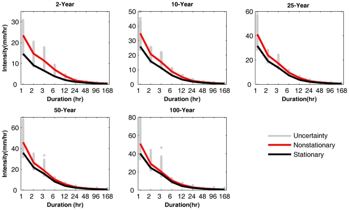
- Cheng, L. and AghaKouchak, A. (2014). Nonstationary Precipitation Intensity-Duration-Frequency Curves for Infrastructure Design in A Changing Climate. Scientific Reports. 4
- North Carolina Urban Forest Council. “Tree Protection During Construction.” https://www.ncufc.org/tree-protection-during-construction.php
- Baker, P. (2006). “Soil-Compaction-Diagram.” Hollandscapes. https://www.hollandscapes.co.uk/landscaping-to-improve-clay-soil/soil-compaction-diagram/
- Bonetti, S., (2021). The legacy of plant roots affects large scale hydrological processes. Sustainability. https://sustainabilitycommunity.springernature.com/posts/the-legacy-of-plant-roots-affects-large-scale-hydrological-processes
- “Growing a Meadow.” The Meadoway Explore. https://themeadoway.ca/restoration/
- National Association of City Transportation Officials (NACTO). Urban Street Stormwater Guide – Bioretention Cell Sizing. https://nacto.org/publication/urban-street-stormwater-guide/stormwater-elements/bioretention-design-considerations/bioretention-cell-sizing/
- National Association of City Transportation Officials (NACTO). Urban Street Stormwater Guide – Bioretention Swale. https://nacto.org/publication/urban-street-stormwater-guide/stormwater-elements/green-stormwater-elements/bioretention-swale/
- U.S. Environmental Protection Agency (USEPA). (2012). City of Neosho Green Infrastructure Design Handbook.
- “The Role of Trees and Forests in Healthy Watersheds.” PennState Extension, 30 Aug. 2022, https://extension.psu.edu/the-role-of-trees-and-forests-in-healthy-watersheds
- USDA. (2012). Plant Hardiness Zone Map. https://planthardiness.ars.usda.gov/
- “Subdivision Scale Rainwater Harvesting: A Solution for Texas?” Public Citizen, 1 May 2019, https://www.citizen.org/news/subdivision-scale-rainwater-harvesting-a-solution-for-texas/.
- “Greater Design Resilience Achieved Thanks to ACO's Patented Blue Roof Attenuation System.” Specification Online, Specification Online, 28 Feb. 2022, https://specificationonline.co.uk/sections/sustainability/articles/2022-02-28/aco-building-drainage/greater-design-resilience-achieved-thanks-to-aco-s-patented-blue-roof-attenuation-system.
- “Kauffman Center for the Performing & Arts District Garage Kansas City, Missouri.” JBC. http://www.jlbruce.com/kauffman-center-for-the-performing-art
- “How Cities Are Incorporating Green Infrastructure to Help with Storm Surges.” Norwalk Tomorrow, 14 Nov. 2019, https://tomorrow.norwalkct.org/news/cities-incorporating-green-infrastructure-help-storm-surges/
- Capitol Region Watershed District. “Upper Villa Park.” https://www.capitolregionwd.org/projects/upper-villa-park/
This page was last edited on 7 May 2024, at 16:22.