Tracking street sweeping activities
This page provides a discussion of why and how to track street sweeping program activities. Street sweeping is the capture and removal of debris from roadways prior to entering the storm drain system. This debris includes natural and manmade organic and inorganic materials such as leaves, sediment, food scraps, garbage, deicer salt, and roadway materials. This guide covers why tracking street sweeping efforts is important, how to track street sweeping, and an evaluation of various tracking methodologies.
Contents
Why track street sweeping
Reasons for engaging in street sweeping vary based on desired benefits street sweeping provides. Benefits include but are not limited to the following.
- Improved Water Quality of downstream waters related to removal of garbage (trash, floatables), suspended sediments, particulate heavy metals, and nutrients like phosphorus and nitrogen
- Improved Roadway Safety for vehicles, bicycles, and pedestrians by removing physical obstacles and preventing debris from clogging storm drains, which can lead to localized flooding hazards
- Improved Aesthetics of roadways, sidewalks, and downstream waterways
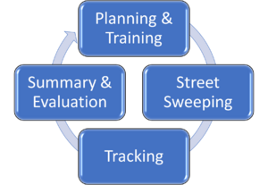
The adjacent image illustrates a four-step process for street sweeping. Tracking occurs after sweeping and is an essential step prior to evaluation, documentation, and reporting (Summary and Evaluation). Tracking is important and beneficial for any of the following reasons.
- Program or Permit Compliance: Compliance with total maximum daily loads (TMDLs), MS4 permits, or other program requirements may require documentation of observable and/or quantifiable improvements associated with pollutant reduction(s). Typically, related pollutants include total phosphorus (TP), total nitrogen, sediment, or trash/floatables.
- Asset Management: Tracking usage and trends of street sweeping can be integral to keeping up with potential and/or required scheduled maintenance on vehicles and equipment. Successful fleet management improves program effectiveness and minimizes conflicts between various department schedules and routes for curbside recycling and trash collection.
- Positive Benefit Quantification: Whether sweeping activities are conducted exclusively for aesthetic reasons (to keep streets and roadsides attractive) or for health and safety purposes (to keep travel ways obstacle-free for vehicles, bikes, and pedestrians), quantifying improvements provides proof of benefit if questions arise related to justification for maintaining or increasing expenditures of public funding allocations.
- Program Effectiveness Evaluation: Tracking sweeping activities can be used to evaluate the effectiveness of the sweeping program, identify shortfalls, successes, potential sweeping hot spots, and trends across a municipality. Data on debris collected per curb mile swept for example can indicate that some locations should be swept more or less frequently to optimize removal. Frequency and timing of sweeping events can inform potential schedule modifications to maximize debris collected prior to storm events. Additionally, vehicles which consistently underperform relative to other sweepers in similar conditions may indicate that available equipment is not adequate.
- Public Engagement: The success of a street sweeping program is reliant on community engagement. Personal vehicles must be moved to adequately sweep curb and gutters, and yard waste such as grass clippings and leaves should not be swept into the roadway. When the public understands why a sweeper program exists, they are more likely to recognize and value their role in the success of the program. Public engagement includes access to static maps of street sweeping routes and schedules, live tracking of sweeper fleet vehicles online, automated email or text programs, and more. Additionally, tracking sweeper activities can be a useful tool of historical record when resolving service disputes.
How to track street sweeping
How a municipality, agency, or consultant tracks their street sweeping program efforts depends primarily on why they are performing street sweeping activities and what resources are available. According to a recent Minnesota Pollution Control Agency (MPCA) street sweeping survey of Minnesota communities, the greatest challenge facing street sweeping programs statewide is funding, which plays a large role in deciding when and where to sweep and how to track sweeping. Implementation of a tracking method involves a three-step process.
- Determine the goal(s) of street sweeping (e.g., water quality, aesthetics, etc.)
- Identify questions that need to be answered
- Identify data that need to be collected to answer the question(s)
To successfully implement a tracking method, instructions for what data to collect and how to collect and record it should be clear and simple. Tracking efforts in the long run should provide enough information to accurately record sweeping activities, while not requiring overly burdensome work for staff
Data tracking and management of street sweeping activities must strike a balance between collecting data at a fine enough resolution to provide helpful insight to the program, while at a coarse enough resolution to remain manageable for those conducting the tracking. There is no one-size-fits all method for tracking street sweeping activities because of factors which can vary by municipality, neighborhood, and street, including:
- Type, number, hopper volume, sweeper width, speed, and age/condition of sweeper vehicles
- Number and attentiveness of staffing of sweeping program drivers, managers, and support staff
- Funding of sweeping program
- Access to various potential resources (external scales, internal hopper scales, various computer software and/or Global Positioning System (GPS) devices,
- Frequency and timing of sweeping (daily or seasonally; regularly scheduled or targeted)
- Volume of vehicle and pedestrian traffic on roadway swept
- Land use, land cover, and tree cover of the drainage area and adjacent to the roadway
- Frequency and intensity of local weather (wind, rainfall, snowfall, freezing temperatures, etc.)
- Presence and frequency of obstructions such as parked cars or low-hanging vegetation
The level of detail and/or specificity included in data tracked from sweeping events varies greatly based on the capacity, interest, and/or requirement a municipality may have to further analyze and evaluate the sweeper data to potentially optimize program activities.
Tracking methods
There are many ways to track street sweeping activities, though they can be divided into the following two categories.
|
There are many ways to track street sweeping activities, thought they can be divided into the following two categories.
- Tracking debris collected
- Tracking distance swept
Tracking objectives, advantages, disadvantages, and challenges for some of the most common tracking methods are discussed below.
Some methods are borrowed from other municipal tracking methods associated with fleet management such as those used for tracking snowplows or road winterizing application vehicles. Some methods are relatively low-tech, while others require significant investment in electronic tracking hardware and software. While tracking of street sweeping activities can have a perceived burden on municipal staff, there are some tracking approaches that do not involve cumbersome paperwork, but rather can be accomplished with an upfront lift in developing a “hybrid approach” to tracking.
Below are descriptions of various methods that can be employed to track street sweeping activities. Typically, municipalities track distance swept or debris collected, or both. Tracking methods can be combined to establish routines that work for an individual municipality based on time, budget, and goals for tracking. Although uncommon, effectiveness of a street sweeping program can be monitored indirectly by tracking water quality within the storm drain system; however, this method takes significantly more time and requires an extensive level of effort before a difference in water quality can usually be documented. The various common methods for tracking street sweeping for water quality described in this section are ones which can most directly apply to using the MPCA Street Sweeping Credit Calculator for TP removal credit for street sweeping activities:
- Distance Swept: Manual Records
- Distance Swept: GPS Recording
- Debris Collected: Mass Measurement
- Debris Collected: Mass Measurement with Lab Analysis
- Debris Collected: Volume Measurement
- Debris Collected: Volume-Mass Relationship Development
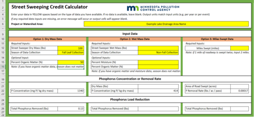
To calculate TP load reduction credit using the MPCA Street Sweeping Credit Calculator, minimum inputs include either curb miles swept (which can be tracked by methods 1 or 2 above), pounds of sweeper debris as wet mass (tracking method 3), or pounds of sweeper debris as dry mass which can be ascertained using tracking method 3 with additional laboratory analyses (method 4). Tracking based exclusively on volume of sweeper loads (tracking method 5) is not currently linked to TP load removal credit; however, where volume to mass relationships can be developed (tracking method 6), mass methods can be employed.
Distance swept: manual records
|
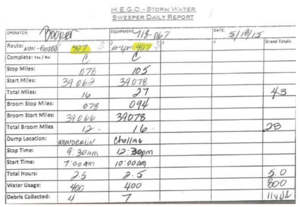
The distance swept by a street sweeping vehicle can be recorded manually by an operator (on paper logs and/or input into a spreadsheet or database) using a variety of options which may include recording:
- Manhours completed by an operator
- Total curb miles swept vs. lane miles swept
- Beginning and end of sweeping route odometer mileage
- Tracking completion of a planned route with known mileage (typically lane or curb miles)
Tracking distance swept can be a useful way to address asset management, positive benefit quantification, and public engagement objectives. If sweeping for water quality benefits, this tracking method can only be used to calculate credits using the miles swept option in the MPCA Street Sweeping Credit Calculator, which results in the lowest TP credit.
It should be noted that any methods which involve estimation on behalf of street sweeping staff or program managers are not recommended. Estimating the distance swept based on an approximation of when sweeper brooms are engaged or based on likely routes driven has significant room for inaccuracy due to impracticality of tracking parked cars or route changes that can throw off planned routes and mileage.
Distance swept: GPS records
Digital automated recording of distance swept is a higher tech option and produces high accuracy results. Onboard GPS and/or Automatic Vehicle Locator (AVL) devices allow for integrated fleet management between sweeper vehicles. Depending on the type and features of GPS/AVL hardware and software employed, beneficial features may include
- precise tracking of routes driven,
- vehicle speed (which may inform sweeper broom engagement),
- actual sweeper broom engagement or disengagement,
- time savings for operators to perform duties without manual tracking,
- reduced fuel costs and mileage with route optimization,
- job performance verification,
- deterrence of equipment theft with tracking capabilities to retrieve equipment,
- generation of maintenance alerts, and
- usage for better job performance like pre-start check lists.
GPS/AVL for fleet management can be expensive; however, results can lead to cost-saving measures down the road. Many municipalities employ GPS trackers on snowplow fleets. These specific hardware and software linkages may also be employed for street sweeping fleet management and tracking.
GPS records of distance swept can be used to address asset management, positive benefit quantification, and public engagement objectives. If sweeping for water quality benefits, this tracking method can only be used to calculate credits using the miles swept option in the MPCA Street Sweeping Credit Calculator, which results in the lowest TP credit.
Debris collected: mass measurement
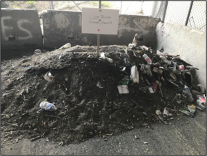
Traditional mass measurement of sweeper debris is the weighing of a sweeper waste load by a number of potential methods.
- On an internal hopper scale (integrated or using an aftermarket on-board scale)
- Weighing by deposition/offloading onto an external scale at a disposal site
- Weighing a sweeper vehicle on a truck scale both before and after conducting sweeping activities, accounting for applicable differences in masses of fuel and water.
This type of mass measurement is considered “wet mass” in the context of TP load reduction using the MPCA Street Sweeping Credit Calculator because “dry mass” is only obtained when sweeper waste has undergone desiccation techniques in a laboratory. When wet mass is measured for water quality, it is valuable to record the season of data collection (fall or non-fall leaf collection season) because street sweepings from the fall season are typically laden with organic leaf matter, which correlates with higher TP removal credit using the MPCA Credit Calculator. Due to this strong seasonality observed in Minnesota municipal datasets, it may be advantageous to collect wet mass measurements by individual load or of aggregate debris piles from a given time period.
The accuracy of estimating true TP load reduction associated with street sweeping can be increased by processing representative samples of seasonal sweeper loads for laboratory analysis (see next section).
Debris Collected: Mass Measurement with Lab Analysis
Directly weighing street sweeping waste collected from sweeping events yields the wet mass. To obtain the dry mass, a representative sample or set of samples is collected for percent moisture analysis (dry basis moisture content). The analysis may be done by a laboratory or on-site following procedures described in Methods for sampling street sweeping material - Standard Operating Procedures. The resulting information can be applied to the relevant sweeper load(s) to approximate the total load dry mass as a function of the known wet mass and the dry basis moisture content. An additional laboratory analysis that can be input to the MPCA Street Sweeping Credit Calculator is percent organic matter content, which can refine TP load reduction credit based on an empirical relationship between organic matter content and TP concentration in street sweeping waste materials. Further lab analyses can also identify the locally specific TP content associated with sweeping materials, though this method is not available for credit in the MPCA Street Sweeping Calculator.
Higher accuracy in quantifying TP removal from street sweeping can be achieved by conducting representative laboratory sampling of multiple sweeping loads from various seasons, watersheds, and primary routes in the municipality. While the gold standard for approximating quantifiable TP removed from sweeping is direct measurement of TP content in sweeper waste via laboratory methods, significant research has shown valuable empirical relationships can be developed between various data tracking methods and lab results for percent moisture, percent organic matter, nutrient content and more (Hobbie et al., 2020; King et al, 2020). High-intensity mass measurements (high frequency, comprehensive geographic/seasonal representation) of sweeping waste and associated laboratory analysis can be used to develop empirical relationships between easier-to-track methodologies (such as total load wet weight or total load dry weight), and these more direct methods of determination of TP mass present in a typical sweeping load.
Tracking of the wet mass or dry mass of sweeper waste collected requires additional time and funds beyond what is needed for conducting the sweeping activities themselves, especially if laboratory analyses are used. However, the additional benefits of higher potential TP crediting relative to distance swept may outweigh the costs.
Debris collected: volume measurement
Tracking the volume of sweeper debris collected requires knowing the volume of each street sweeper hopper and tracking how full each hopper is when it is emptied. Measurement of the volume of swept materials requires recording the volume of each hopper load that is collected. Volume tracking may contribute to asset management, positive benefit quantification, program effectiveness evaluations and public engagement objectives. However, it is not currently a viable option for tracking when sweeping for water quality credit is an objective. The MPCA Street Sweeping Credit Calculator currently does not have an option for entering a volume of swept material to calculate pounds of TP removed because empirically based relationships have not yet been developed for this metric in a reliably applicable manner. To receive water quality credit in terms of TP removal, a relationship between volume and mass must be developed (see next section).
Debris collected: volume-mass relationship development
The MPCA Street Sweeping Calculator does not currently include input of volume of street sweeping debris directly for TP load reduction credit due to a lack of empirically based data. Although MPCA is supporting ongoing research to potentially develop volume-to-mass relationships for TP load reduction credit, municipalities may wish to collect data to develop locally specific relationships. If a municipality is interested in developing a locally specific relationship, it is required that they seek approval from MPCA prior to engaging in the process to ensure appropriate methodologies and best practices are established. When the goal of street sweeping is related to water quality, there can be value in developing locally specific relationships between an easier-to-measure tracking element (such as wet mass collected) and a more difficult-to-measure tracking element (such as actual total phosphorus removed by street sweeping).
Representative tracking can be conducted to develop an empirical relationship between a full hopper load of swept materials and the average mass of the swept materials. The total mass is tracked by recording the number of full or partially full hoppers collected during sweeping events. This mass to full hopper volume relationship can be developed through a pilot study using the actual mass of hopper contents for several locations throughout the jurisdiction, with consideration in variability between seasons, routes, watersheds, sweeper type, and potentially other factors. Although estimating wet mass by volume is less precise than weighing sweeper loads by direct measurement, if supported by empirical relationships, counting hopper loads is very inexpensive and low-tech in the long term.
Tracking methods summary
Most municipalities perform some level of tracking street sweeping activities associated with distance swept and/or debris collected. When the goal of street sweeping is related to water quality, there is value in developing locally specific relationships between an easier-to-measure tracking element (such as wet mass collected) and a more difficult-to-measure tracking element (such as actual TP concentration removed by street sweeping). The various methods detailed in the above sections are summarized below relative to their advantages, disadvantages, data collected, and TP load reduction potential.
Summary of street sweeping tracking methodologies
Link to this table
| Tracking method | Advantages | Disadvantages | Data collected | Relative TP load reduction credit potential1 |
|---|---|---|---|---|
| Distance Swept: Manual Logging |
|
Low accuracy, reliant on self-reporting | Miles swept | Low potential |
| Distance Swept: GPS Records | Automated tracking | More expensive than manual logging (hardware, software, data interpretation) | Miles swept | Low potential |
| Debris Collected: Mass Measurement | Once method is established, easy to track | Requires special equipment (scale) | Wet mass of swept materials | High potential |
| Debris Collected: Mass Measurements with Lab Analysis | More representative of actual material swept | Pilot study may be initially time intensive and costly | Wet mass of swept materials plus initial lab work for dry basis moisture content, and optionally organic matter content, TP content | High potential and high accuracy |
| Debris Collected: Volume Measurement |
|
Not currently applicable for TP load reduction credit by MPCA | Count of hopper dumps | No potential |
| Debris Collected: Volume-Mass Relationship | Provides pathway for TP load reduction credit based on a low-tech measurement | Pilot study may be initially time intensive and costly | Count of hopper dumps plus initial lab work in developing volume/mass relationship | High potential |
1Relative TP Load Reduction Credit Ratings based on the MPCA Street Sweeping Credit Calculator:
|
||||
Data logging
Data Logging is the process of collecting and storing data over a period of time for potential review and analysis
Once a street sweeping program establishes its sweeping methods, frequencies, waste disposal, and practices – data logging is important to keep records of sweeping data. Data logging for street sweeping provides programmatic insight on efficiencies or inefficiencies, identifies areas for enhanced or targeted sweeping, allows for program optimization, and ensures future program funding on a basis of demonstrating quantifiable progress with value to the community both aesthetically and for water quality. The manner in which data is logged is dependent on identification of the best tracking method to efficiently capture monitoring data that answers the question a municipality is asking based on available resources.
Data logging of street sweeping tracking data can include paper records, Excel spreadsheets, Access databases, web-based applications (e.g., PlowTracker), tablets (e.g., iPads), smart trackers (e.g., AVL), etc. The following questions may help a program identify which tracking methods works best for them.
- Does the city prefer a specific proprietary software system for municipal records?
- Who will be in charge of data tracking, data entry, data reporting, and data summary?
- Are there staff who are proficient in geographical information systems (GIS) and/or GPS?
- Are other municipal vehicles/programs tracked in a way that can be mirrored (e.g., snowplows)?
- Are existing tracking methods providing data sufficient to meet program goals?
- Is there a regulatory reason to track data a specific way (e.g., tracking by watershed)?
There is no one-size-fits-all solution, but the examples used for several municipalities across the country included in the following section give some perspective into how and why various data logging options are implemented. No matter which method is selecting for tracking, data management that is easily accessible and understandable is crucial for a successful program. Being able to analyze data collected is essential to answering the question of whether the street sweeping program is meeting its goals.
Data reporting
Whether the purpose for of street sweeping activities is focused primarily on receivinggenerating phosphorus removal credit, meeting permit requirements, or for other reasons, after data is tracked and logged, it is reported. Sometimes data reporting comes in the form of monthly, quarterly, or annual reporting of municipal activities for review and accounting. For potential credit for phosphorus removal, all tracked and logged data should be documented and reported with sufficient detail to adequately estimate credit for the methodology selected (e.g., mass collected).
Case studies
Municipalities across the United States perform and track street sweeping activities in various ways based on their specific goals and available resources. The fall 2021 MPCA volunteer survey of street sweeping programs across Minnesota indicated that both funding and staff remain challenges for programs, so those items may drive which tracking methodology is feasible for a given municipality. Many municipalities that already have GPS tracking devices and software for monitoring a snowplow fleet employ the same methodology for tracking routes of street sweepings. Several examples of tracking methodology employed within and outside of Minnesota are included below. See Case studies for street sweeping.
Examples of Street sweeping tracking methods in various municipalities
Link to this table
| Municipality | Tracking methods |
|---|---|
| Forest Lake, Minnesota | GPS tracking is conducted with proprietary software. Route completion status is recorded by software with mileage calculated internally. Operators record debris load weights which are input into an Excel spreadsheet. |
| Lakeville, Minnesota | GPS/AVL tracking is used for street sweeper fleet and snowplow fleet. The city uses ESRI’s GeoEvent server to connect and record data online with a publicly accessible interface. Drivers do not record mileage manually since it is digitally logged and stored in a SQL database. Sweeper loads are not screened, but total tonnage amounts are provided via invoice from the landfill after disposal. City staff log the total count of hopper loads of fall leaf litter, but individual load weights or volumes are not measured. Some of the biggest challenges have been related to software reliability using the GPS/AVL system. |
| Rochester, Minnesota | Rochester uses GPS/AVL tracking with the proprietary software system PreCise (same system used for snowplow fleet). Web-based software runs reports, tracks sweeper progress, and live exports to ArcGIS for mapping for residents theoretically (no current GIS team capacity for this last item). Sweepers were recently equipped with GPS, so they are using paper logs and electronic logs to compare tracking results. They log paper records in an Access database, but its less supported, so they are looking for a long-term solution. It is too labor and time intensive to ask drivers to manually track sweeper broom engagement, which the GPS tracking input can track. The biggest challenge is that the electronic tracking cannot currently track the kind of sweeping performed, but the city categorizes its sweeping by time of year as “spring sand” or “fall leaves”. Sweeper staff tried using iPads installed in cabs, but it was too cumbersome. They perceive volume/weight of material hardest to track. The iPad tracking counted hopper dumps. The Pelican sweeper allows users to raise/shift the hopper to get more space while sweeping, so counting hopper dumps was not providing a consistent metric. In addition, the hoppers are emptied opportunistically when the collection dump truck passes by leading to uncertainty in how full each hopper is. Rochester tracks the number of hopper dumps and swept mileage but believe they should weight material for accuracy in the future. |
| St Cloud, Minnesota | Street sweeper operators of 3 broom-style and 2 regenerative air sweepers do not manually log miles swept but manually log full loads dumped directly into larger dump trucks for disposal. No GPS system is currently used for tracking, but the city hopes in the future to use an AVL system to track areas swept each day. Tracking at this time is detailed with the following process: All sweeping full loads are counted and tracked, but methods vary seasonally. In fall, leaf sweeping loads are not screened, but total loads are weighed prior to composting (averaging 3 tons per load). Load counts are kept and recorded by sweeper operators. Spring/Summer sweeping loads are counted and tracked, with a total seasonal pile that is stored until end-of season screening of “spoils” (swept material is weighed as it is screened using a scale on the loader) and the non-recyclable trash component is sent to the public landfill (approximately 2% of loads), while remaining waste is recycled or composted. The city keeps statistics on sweeping including annual averages: 2,000 lane miles of streets and alleys, 4,500 staff hours, 500 pre-screened dump truck loads of waste, 3,000 tons of material removed, and an estimated 1,500 pounds of TP removed. |
| Bloomington, Minnesota | The city conducts its own street sweeping with 3 Pelican sweepers and 2 regenerative air sweepers. Sweeper drivers do not manually log miles swept or full loads of sweeper waste dumped; however, sweeper trucks are tracked using GPS routed to PreCise software. Sweeper waste loads are weighed at the disposal location, lumped together from all sites. The city is working on a process to accurately weigh subsets of swept material to identify sweeping load mass associated with designated zones around the city. |
| St. Anthony, Minnesota | The city uses a single street sweeper vehicle for which the operator uses paper logs to manually record miles swept. Sweeper data logs are input into an Excel spreadsheet, documenting miles swept, estimated material volume collected (count of full hopper loads dumped), and the associated watershed where the material was collected. |
| Durham, North Carolina | Durham uses a hybrid approach to tracking street sweeping based on North Carolina Department of Environmental Quality methods. In 2020, the city conducted a pilot study to weigh their sweeper trucks (with full gas and water tanks) with and without full sweeper waste loads at the city’s Solid Waste Disposal and Recycling Center truck scales. Loads were dumped onto a fresh plastic drop cloth, photographed, tallied for observable items, and composite representative subsampling of the pile was conducted for laboratory analysis of dry weight, particle size distribution, metals, nutrients, etc. This detailed sampling method was completed once per season due to spring impacts of grass clippings in sweeper debris. The city then developed seasonally specific relationships of pounds of TP removed per curb mile swept based on their data which they use moving forward (and to back-calculate previous years) to estimate pounds of TP removed by only tracking curb miles swept. |
| Salt Lake City, Utah | Salt Lake City uses real-time GPS tracking on its snowplow fleet which can be organized using the SnowPaths application for fleet management. SnowPaths records truck types, names, locations, starts and stops, percent of planned route completion, whether plows were engaged or not, idle times, and generates reports. The app can also indicate how many hours it has been since a particular road was last plowed for prioritization. While not a specific street sweeping example, this demonstrates that an GIS/AVL app like SnowPaths could be utilized during non-snow seasons for street sweeping, since much of the same data are needed for tracking both activities. |
References
- Hobbie, S.A., R. King, T. Belo, L.A. Baker, J.C. Finlay. 2020. Developing a Street Sweeping Credit for Stormwater Phosphorus Source Reduction: Final Report. Minnesota Stormwater Research Council.
- King, R.A., L.A. Baker, J.C. Finlay, T. Belo, S.E. Hobbie. 2020. Developing a Street Sweeping Credit for Stormwater Phosphorus Source Reduction: Report to Inform Phosphorus Credit for Street Sweeping. Minnesota Stormwater Research Council.
This page was last edited on 20 December 2022, at 22:36.
