![]()
Case study for using the MIDS calculator to meet TMDL permit requirements
The following case study highlights an example total maximum daily load (TMDL) and describes how a Municipal Separate Storm Sewer System (MS4) permittee can use the Minimal Impact Design Standards (MIDS) Calculator to evaluate wasteload allocation (WLA) compliance.
Contents
TMDL Description: Lake Independence Phosphorus TMDL
| MS4 | Existing TP loading | WLA TP loading | TP load reduction (lbs) | ||
| lbs/year | lbs/day | lbs/year | lbs/day | ||
| Independence | 891 | 2.44 | 356 | 0.95 | 535 |
| Loretto | 69 | 0.19 | 16 | 0.07 | 53 |
| Medina | 515 | 1.41 | 231 | 0.63 | 284 |
| Total | 1475 | 4.04 | 603 | 1.65 | 872 |

The Lake Independence Phosphorus TMDL (MPCA, 2007) is a nutrient TMDL completed for Lake Independence (AUID 27-0176-00) located in the Pioneer-Sarah Creek Watershed approximately 15 miles west of the City of Minneapolis. The WLA developed by the approved TMDL is shown on the right.
The WLA developed in the Lake Independence Phosphorus TMDL document is an individual WLA, meaning that allocations are assigned to each individual MS4, rather than combining the WLAs assigned to all MS4s into a single combined (categorical) WLA. The TMDL and WLAs developed in the TMDL document include an estimate of existing loading (pounds of TP per year, lbs/yr), WLA TP loading, and pounds of TP reduction required by each MS4 to achieve the WLAs. TMDLs structured in this way provide clear guidance and reduction targets for included MS4s.
MS4 compliance: Medina
The following subsections provide an overview of reporting related to TMDL requirements and how the City of Medina could use the MIDS Calculator to evaluate and demonstrate progress towards TMDL compliance. The following links provide information related to permit compliance and to the TMDL and TMDL Implementation Plan.
- Summary of TMDL requirements in storm water permits
- MS4 Permit TMDL Attachment Spreadsheet
- 2020 MS4 General Permit
- Lake Independence Phosphorus TMDL
- Lake Independence TMDL Implementation Plan
- City of Medina TMDL Annual Report Form (2017)
Using the MIDS Calculator to demonstrate WLA compliance: Medina
As shown in the City of Medina’s TMDL Annual Report Form for 2017, the City has achieved 30 lbs/yr of TP reduction since completion of the Lake Independence Phosphorus TMDL. Comparing this reduction to the required WLA reduction of 284 pounds per year, Medina has achieved 11% of the required TP reduction. To track progress towards achieving their WLA target reduction goal, the City of Medina may choose to use the MIDS Calculator to both track existing water quality BMP performance and evaluate implementation of proposed BMPs. The MIDS Calculator can be used to produce annual removal estimates for a large variety of BMPs from a variety of land uses and is therefore an acceptable model for evaluating WLA compliance. An overview of general steps which could be taken by Medina to demonstrate compliance with the Lake Independence Phosphorus TMDL using the MIDS Calculator is included below. More detailed information related to each step can be found in the Lake Independence TMDL Implementation Plan.
Note: the case study example developed in this section is provided as an example of how an individual MS4 can demonstrate WLA compliance using the MIDS Calculator, and was not developed with input or coordination with the MS4 permittees.
| MS4 | Proposed annual TP WLA loading reduction (lbs/year) | |||||
| Loretto sewage treatment facility | Livestock manure management | Failing septic systems | Agricultural cropland | Urban development | Geese management | |
| Independence | - | 260 | 6 | 187 | 80 | 8 |
| Loretto | 53 | - | - | - | - | - |
| Medina | - | 110 | 2 | 97 | 66 | 3 |
| Total | 53 | 370 | 8 | 284 | 146 | 11 |
1) Review applicable WLAs developed in the TMDL. The Lake Independence TP TMDL develops a target WLA reduction target of 284 lbs/yr for the City of Medina (Lake Independence Phosphorus TMDL; MPCA, 2007). In addition to developing WLA targets for the three MS4s included in the TMDL, the TMDL includes recommended target reduction from six (6) individual sources, as shown on the right. The table shows that reductions from a number of sources will likely be needed for the City of Medina to achieve its target WLA reduction.
Note: Typically, some of the sources identified in the table, such as agricultural cropland, would be included in the load allocation and the permittee could not be credited for reductions associated with these sources. However, because the entire jurisdictional area of the City within the watershed was included in the WLA, regardless of current loand use, the activities shown in the table may be credited toward the WLA if they occur within the City's jurisdictional area. For example, conversion of cropland to residential development could be credited toward the WLA if the conversion resulted in a reduction of phosphorus loading.
Of the sources included in the table, “urban development” (i.e., load reduction from urban development achieved through BMP implementation) is the only source that can be evaluated and tracked using the MIDS Calculator. The “agricultural cropland” source is another that could potentially be evaluated using the MIDS Calculator (e.g., evaluate structural water quality BMPs receiving runoff from agricultural areas), but as discussed in the TMDL Implementation Plan (see step #6), implementation options for agricultural cropland include large-scale land management practices (e.g., land terracing, riparian buffers, nutrient management) which can be evaluated using other models (e.g., Revised Universal Soil Loss Equation (RUSLE)). For this reason, subsequent steps included in this case study example focus on achieving the required WLA reduction from urban areas for the City of Medina.
Note: The table on the right is a guide to sources that contribute to phosphorus loading. The reductions shown in the table are not required reductions, but instead target reductions. The permittee may choose to address any or all of these sources. The required reduction is 284 lbs/yr, regardless of the phosphorus source.


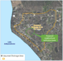
2) Review the drainage area used to develop the TMDL. The portion of Medina included in the TP TMDL for Lake Independence is shown on the left. Approximately 4,500 acres of Medina is included in the Lake Independence drainage area, which is approximately twenty-five percent (25%) of the total municipal area of Medina. It is critical to determine the drainage area the TMDL applies to, as the WLA and required pollutant reduction apply only to the area tributary to the impaired waterbody. Because the WLA applies to the impaired water, pollutant reduction achieved within the MS4 but not within the tributary area to the impaired water does not apply to the required reduction targets developed by the WLA.
Note: for TMDLs developed for large, regional waterbodies, the tributary MS4 area may be the entire municipal area. If the applicable MS4 area is not clearly outlined within the TMDL, mapping and associated digital files can be requested directly from the MPCA.
3) Review the TMDL modeling period and existing BMPs incorporated into the TMDL (i.e., determine the baseline condition used to establish the WLA). In addition to determining existing loading and required pollutant reduction, it is critical to determine (a) what modeling period was used to establish the TMDL and (b) what BMPs were incorporated into the TMDL model used to develop WLA reduction targets. Before selecting an annualized model (i.e., models that produce annualized, rather than continuous results), it is critical to first make sure that applicable TMDLs are also developed on an annualized basis (e.g., required pounds of TP reduction per year). If the TMDL was developed for a non-annualized period (e.g., the April to October growing season), annualized models like the MIDS Calculator, MPCA Simple Estimator, etc. may not be the best choice for evaluating WLA compliance.
Note: if desired, the permittee can contact and work with MPCA stormwater staff to adjust the non-annualized WLAs (e.g., growing-season) to annualized WLAs.
Review of the Lake Independence TP TMDL shows that existing loading and TMDL loading was developed annually based on “normal annual precipitation”. Because the MIDS calculator estimates annual loading and BMP removal for average annual precipitation for the assigned Minnesota zip code, the MIDS Calculator is a good candidate model for evaluating and demonstrating WLA compliance for this TMDL. Further review of the Lake Independence TP TMDL shows that existing loading and TMDL loading was developed using BATHTUB calibrated to monitored stream inflow data collected in 2001 and lake water quality data collected from 1990 to 2003. Because the model was calibrated to watershed conditions during these periods, the model implicitly incorporates treatment from lakes, ponds, and BMPs which existed in the watershed during this period. The TMDL establishes a baseline year of 2001. The baseline year is the year which establishes the watershed condition for the TMDL, meaning that any BMPs constructed post-2001 within the portion of Medina tributary to Lake Independence can be incorporated into the MIDS Calculator model and counted towards Medina’s WLA reduction target
4) Develop an inventory of existing water quality BMPs related to the TMDL pollutant. There are many large wet ponds, wetlands, and lakes within the portion of Medina tributary to Lake Independence. All wet ponds, lakes, wetlands, and other BMPs constructed or existing in the watershed prior to 2001 are implicitly included in existing conditions modeling used to develop the TMDL (see discussion in step #3), but any BMPs constructed or implemented (e.g., street sweeping) post 2001 were not incorporated into TMDL modeling and can therefore be modeled and counted towards Medina’s WLA reduction target. For this reason, it is critical that permittees develop an inventory of all structural (e.g., infiltration BMPs) and non-structural BMPs (e.g., street sweeping) within the portion of the MS4 tributary to the impaired water body. For maintenance and tracking purposes, some MS4s may already have an established BMP inventory, while other will need to create a BMP inventory for the purposes of WLA compliance evaluation and tracking. For the Lake Independence TP TMDL, a list of structural and non-structural BMPs to consider in the existing BMP inventory is listed, below.
Note: a detailed implementation plan for targeting each TP loading source is included in the “Implementation Plan” section of the Lake Independence Phosphorus TMDL (MPCA, 2007). Many of the non-structural BMPs listed below were developed directly from the Lake Independence TMDL implementation plan and may not be specific to WLA compliance.
Examples of structural BMPs to inventory related to TP reduction include the following.
- Wet ponds
- Bioretention (i.e., rain gardens)
- Infiltration basins and trenches
- Sand filters and iron-enhanced sand filters
- Hydrodynamic separators (i.e., grit chambers)
- Alum and ferric chloride treatment plants
- Spent lime filtration
Examples of non-structural BMPs to inventory related to TP reduction (Barr, 2016) include the following.
- Street sweeping
- City ordinances (e.g., related to agricultural fertilizer application)
- Public education and outreach (e.g., related to establishment of agricultural buffer strips along drainage ditches, crop residue and nutrient management programs, land terracing and contour farming, etc.)
- Improvements to individual sewage treatment systems (ISTSs) inspection and enforcement program
- Manure hauling and disposal service
- Geese removal and management
As discussed above, the Lake Independence TMDL implicitly include all BMPs implemented in the watershed prior to 2001. This means that pollutant reduction associated with any BMPs, structural or non-structural, constructed or implemented post-2001 can be applied towards target WLA reductions. For example, if a raingarden constructed in 2006 was modeled in the MIDS Calculator and found to remove six (6) pounds of TP per year, this could be applied to the WLA reduction.
5) Develop a MIDS Calculator model to evaluate WLA compliance. After review of the TMDL and development of the existing BMP inventory, the next step is to develop a MIDS Calculator model for the drainage area outlined in the TMDL
Note: A number of methods (e.g., monitoring) and models (e.g., the MPCA Simple Estimator) can be used to evaluate TMDL compliance, however, because this section focuses on the MIDS Calculator, the following steps reference model development and analysis using the MIDS Calculator.
- a) Develop inputs for existing BMPs and incorporate into the model. Because the Lake Independence TP TMDL was developed based on watershed conditions prior to 2001, BMPs constructed or existing in the watershed prior to 2001 will not count towards WLA reduction targets, while BMPs constructed post-2001 will count towards WLA reduction targets. For this reason, it is not critical to include BMPs existing prior to 2001 unless a newly constructed or proposed BMP is upstream of the existing BMP features. It is critical to model existing BMPs in series with newly-constructed or proposed BMPs, as reduction provided by the existing BMP will reduce the total reduction achieved in terms of outfall loading to the lake. For example, if a raingarden is constructed which reduces TP by 8 lbs/yr is constructed upstream of an existing, large wet pond which reduces inflow TP loading by 60%, the total load reduction to the lake (i.e., WLA reduction) achieved by construction of the raingarden) may be closer to 3.2 lbs/yr (60% of the 8 lbs/yr).
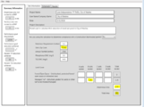
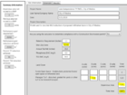
- An example of MIDS Calculator job control parameters and inputs for a wet pond in Medina treating a large parking lot is shown in the image gallery below.
- Note: although this example illustrates a model set up to review one (1) BMP, typically, an MS4 will use one model to evaluate either (a) the entire municipal area, (b) individual models for major watersheds within the MS4 boundary, or (c) the MS4 area tributary to the impaired waterbody, meaning that the MIDS calculator will model and produce results for many water quality BMPs.
- b) Determine existing load reduction and compare to WLA. After generating inputs for all BMPs incorporated into the MIDS Calculator, the MIDS calculator can be run to determine existing load reduction. In the case of the Lake Independence TP TMDL, it is recommended that a version of the existing conditions model be retained which only include BMPS constructed or existing in the watershed prior to 2001 (the TMDL modeling period). Updated versions of the model with BMPs constructed post-2001 and proposed BMPs can then be compared back to the pre-2001 existing conditions model. Using this methodology, any additional TP reduction beyond the pre-2001 existing conditions model represent progress towards the target WLA load reduction, and can be counted towards achieving the WLA target reduction value established in the TMDL. For example, if a wet pond was constructed post-2001, based on the assumed drainage area and BMP dimensions, Medina could take credit for the 3.5 lbs/yr of TP removal calculated at this BMP and apply this reduction to their target WLA reduction.
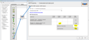
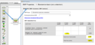
- MIDS Calculator screen shots for inputs for bioretention without an underdrain (bioinfiltration). Click on an image for enlarged view.
Lake independence site information tab
Lake independence schematic tab
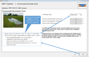
Constructed pond on schematic tab
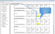
Lake independence results tab


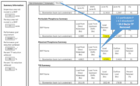
| Phosphorus source | Phosphorus reduction strategy |
| Agricultural cropland | Vegetated buffer strips |
| Animal waste |
|
| Urban development |
|
| Failing ISTS |
|
| Geese |
|
| Loretto Sewage Treatment Facility | Eliminate all discharge of effluent |
6) Review the TMDL implementation plan, Watershed Restoration and Protection Strategies report, Use Attainability Analysis (UAA) report, or other relevant watershed planning documents (if applicable). The Lake Independence Phosphorus TMDL (MPCA, 2007) was updated in March of 2007 to include an expanded “Implementation Plan” section. The implementation plan provides detailed descriptions, cost-estimates, and implementation strategies for achieving the target WLA reduction values from each of the TP sources. The table to the right shows the specific TP reduction strategies evaluated in the implementation plan for each phosphorus source evaluated in the TMDL. The implementation plan is a useful tool for developing a strategy and timeline for achieving WLA compliance, but in the case of the Lake Independence TP implementation plan, the plan does not provide specific recommendation related to BMP implementation.
Note: Phosphorus reduction strategies included below are related to both point (WLA, e.g., raingarden installation) and non-point (LA, e.g., geese management) sources. MS4 permittees may only claim credits for WLA activities.
If the TMDL does not include an implementation plan or does not develop specific recommendations related to BMP implementation, results for the existing conditions MIDS Calculator model can be used to target areas for BMP implementation. One method of identifying and targeting areas of high pollutant loading within the modeled watershed for BMP implementation is to calculate the “watershed pollutant areal loading (pre-treatment) (lbs/acre/year)” and “outflow pollutant areal loading (post-treatment) (lbs/acre/year)”. Joining these results to modeled subcatchment areas allows the user to visualize “hot spots” of pollutant loading generated from the watershed (pre-treatment) and leaving modeled pipe and BMP devices (post-treatment). An example showing watershed pollutant areal loading for the existing conditions for a different TMDL and lake area, the Lake Riley RP TMDL, illustrates how watershed pollutant loading is correlated to land use, with more-developed portions of the watershed generating more TP loading than less-developed areas.
7) Utilize model to track progress towards meeting the WLA (e.g., use the model to evaluate BMPs and incorporate BMPs as they are implemented). As discussed in item #6, above, the existing conditions MIDS Calculator can be used to identify areas to target for BMP implementation, and can be updated as BMPs are constructed to track progress towards attaining WLA compliance. The TMDL implementation plan provides cost estimates guidance regarding the implementation of rain gardens throughout developed portions of the watershed. Based on this recommendation, the following example evaluates the implementation of a large, regional infiltration basin (i.e., bioretention basin w/o underdrain) in a developed portion of Medina between Lake Independence and Lake Ardmore.
Although the majority of Medina consists of undeveloped and agricultural land, there are significant areas of residential development, particularly along the lake shore of Lake Independence. Based on evaluation of area topography, it is assumed for the purposes of this example that the drainage area currently discharges directly to Lake Independence through overland and stormsewer without receiving any treatment in area lakes, ponds, or existing BMPs. To provide water quality treatment to this drainage area prior to discharge to Lake Independence, a large infiltration basin has been proposed. After calculating the drainage area to the infiltration basin, the basin was sized using guidance provided by the MPCA, model inputs were developed and input into the calculator, and the MIDS Calculator was run to determine the annual TP reduction of the proposed regional infiltration basin. As shown in image gallery below, the proposed regional infiltration basin produces 10 lbs/yr of TP reduction. Comparing this value to the target WLA reduction from urban development of 66 lbs/yr, the City of Medina would need to implement 6 to 7 similarly performing BMPs to achieve the target WLA from urban development.
- MIDS Calculator screen shots for inputs for bioretention without an underdrain (bioinfiltration). Click on an image for enlarged view.
Lake Independence proposed infiltration basin
Lake independence site information tab for infiltration
Infiltration basin on schematic tab
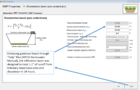
Infiltration basin on schematic tab
Lake independence results tab for infiltration basin


Related pages
- Summary of TMDL requirements in stormwater permits
- Forms, guidance, and resources for completing the TMDL annual report form
- Overview of models used to meet MS4 TMDL permit requirements
- Recommendations and guidance for utilizing P8 to meet TMDL permit requirements
- Case study for using P8 to meet TMDL permit requirements
- Recommendations and guidance for utilizing WINSLAMM to meet TMDL permit requirements
- Case study for using WINSLAMM to meet TMDL permit requirements
- Recommendations and guidance for utilizing the MIDS calculator to meet TMDL permit requirements
- MIDS calculator
- Case study for using the MIDS calculator to meet TMDL permit requirements
- Recommendations and guidance for utilizing the MPCA Simple Estimator to meet TMDL permit requirements
- MPCA Simple Estimator
- Case study for using the MPCA Simple Estimator to meet TMDL permit requirements
- Recommendations and guidance for utilizing monitoring to meet TMDL permit requirements
- Case studies for monitoring to meet TMDL permit requirements
This page was last edited on 12 January 2023, at 16:08.