Soils are typically classified based on a specific property, such as infiltration or texture. This page provides a summary of the more commonly used classification systems.
Contents
- USDA classification based on soil textures
- Natural Resource Conservation Service Hydrologic Soil Groups
- Unified Soil Classification System (USCS)
- American Association of State Highway and Transportation Officials (AASHTO) Soil Classification System
- USDA Soil Taxonomy
- Other classification systems
- Related links
USDA classification based on soil textures
![image of soil texture triangle]](/sites/stormwater/files/Soil_texture_triangle.jpg)
The United States Department of Agriculture defines twelve major soil texture classifications ( sand, loamy sand, sandy loam, loam, silt loam, silt, sandy clay loam, clay loam, silty clay loam, sandy clay, silty clay, and clay). Soil textures are classified by the fractions of sand, silt, and clay in a soil. Classifications are typically named for the primary constituent particle size or a combination of the most abundant particles sizes (e.g. sandy clay, silty clay). Loams are soils having roughly equal proportions of sand, silt, and/or clay in a soil sample.
Texture affects many soil properties, such as infiltration, structure, porosity, water holding capacity, and chemistry. For more information on the role and importance of soil texture, link here.
The soil texture triangle is based on grain size, that is the distribution of sand, silt, and clay in a soil. The texture triangle is shown in the adjacent image. The relationship to hydrologic soil group, which is used in stormwater applications, is illustrated in this image.
Natural Resource Conservation Service Hydrologic Soil Groups
Reference: Urban Hydrology for Small Watersheds - TR-55 (USDA)
Soils are classified by the Natural Resource Conservation Service into four Hydrologic Soil Groups (HSG) based on the soil's runoff potential. The four Hydrologic Soils Groups are A, B, C and D. Where A's generally have the smallest runoff potential and Ds the greatest.
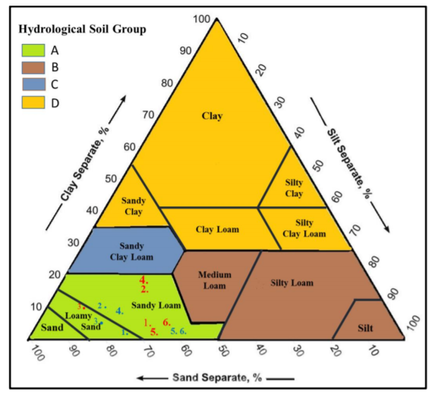
- Group A: sand, loamy sand or sandy loam types of soils. It has low runoff potential and high infiltration rates even when thoroughly wetted. They consist chiefly of deep, well to excessively drained sands or gravels and have a high rate of water transmission.
- Group B: silt loam or loam. It has a moderate infiltration rate when thoroughly wetted and consists chiefly or moderately deep to deep, moderately well to well drained soils with moderately fine to moderately coarse textures.
- Group C: sandy clay loam. They have low infiltration rates when thoroughly wetted and consist chiefly of soils with a layer that impedes downward movement of water and soils with moderately fine to fine structure.
- Group D: clay loam, silty clay loam, sandy clay, silty clay or clay. This HSG has the highest runoff potential. They have very low infiltration rates when thoroughly wetted and consist chiefly of clay soils with a high swelling potential, soils with a permanent high water table, soils with a claypan or clay layer at or near the surface and shallow soils over nearly impervious material.
This classification system is the most widely used system in the Minnesota Stormwater Manual and in most stormwater applications in the U.S. Best management practice (BMP) selection and design are typically based on soils at a site. For example, infiltration bmps are preferred on HSG A and B soils when there are no other site restrictions (e.g. contamination, presence of active karst).
Link to infiltration rates based on hydrologic soil group
Unified Soil Classification System (USCS)
The Unified Soil Classification System (USCS) (see ASTM D-2487) is used in engineering and geology to describe the texture and grain size of a soil. Unconsolidated materials are represented by a two-letter symbol based on type of material (gravel (G), sand (S), silt (M), clay (C), organic (O)) and grading or plasticity (well-graded (W), poorly-graded (P), high plasticity (H), low plasticity (L)). For example, CH materials consist of clay with high plasticity, and SP materials consist of poorly-graded sands. Specific properties of these soils can be found here. This classification is used for engineering applications, where factors such as soil strength and uniformity are important for structural applications.
The adjacent image shows the relationship between the USCS, AASHTO and USDA classifications.
American Association of State Highway and Transportation Officials (AASHTO) Soil Classification System
The AASHTO Soil Classification System was developed by the American Association of State Highway and Transportation Officials, and is used as a guide for the classification of soils and soil-aggregate mixtures for highway construction purposes. It roughly divides soils into two groups, granular and silt-clay materials, based on sieve analysis. Granular materials are considered good as a subgrade, while silt-clay materials are less satisfactory.
| General Classification | Granular Materials (35% or less passing the 0.075 mm (No. 200) sieve) | Silt-Clay Materials (>35% passing the 0.075 mm (No. 200) sieve) | |||||||||||
|---|---|---|---|---|---|---|---|---|---|---|---|---|---|
| Group Classification | A-1 | A-3[1] | A-2 | A-4 | A-5 | A-6 | A-7 | ||||||
| A-1-a | A-1-b | A-3 | A-3a | A-2-4 | A-2-5 | A-2-6 | A-2-7 | A-4a | A-4b | A-7-5 A-7-6 | |||
| Sieve Analysis maximum % passing | |||||||||||||
| 2.00 mm (No. 10) 0.4255 mm (No. 40) 0.0755 mm (No. 200) |
50 30 15 |
... 50 25 |
... 51 10 |
... ... 35 |
... ... 35 |
... ... 35 |
... ... 35 |
... ... 35 |
... ... 36 |
... ... 50 |
... ... 36 |
... ... 36 |
... ... 36 |
| Characteristics of maximum fraction passing 0.425 mm (No. 40) | |||||||||||||
| Liquid Limit | 40 max | ||||||||||||
| Plasticity index | 10 max | ||||||||||||
| Group Index | 0 | 4 max | 8 max | 12 max | 20 max | ||||||||
| Usual types of significant constituent materials | Stone fragments, grave and sand | Fine sand | Sand | Silty or clayey gravel and sand | Silty soils | Clayey soils | |||||||
| General rating as a subgrade | Excellent to good | Good to fair | |||||||||||
| Source: Wisconsin Department of Transportation Notes: With the test data available, the classification of a soil is found by proceeding from left to right on the chart. The first classification that the test data fits is the correct classification. * A-2-5 is not allowed under 703.16B. A-5 and A-7-5 is not allowed under 703.16.A. See "Natural Soil and Natural Granular Soils" (203.02.H) in this manual ** A-4b is not allowed in the top 3 feet (1.0 m) of the embankment under 203.03.A. [1] The placing of A-3 before A-2 is necessary in the "left to right" process, and does not indicate superiority of A-.3 over A-2 [2] A-3a must contain a minimum 50 percent combined coarse adn find sand sizes (passing No. 10 but retained on No. 200, between 2 mm and 75 ųm. [3] A-4a must contain less than 50 percent silt size material (between 75 ųm and 5 ųm). [4] A-4b must contain 50 percent or more silt size material (between 75 ųm and 5 ųm). |
|||||||||||||
The adjacent image shows the relationship between the USCS, AASHTO and USDA classifications.
USDA Soil Taxonomy
USDA soil taxonomy provides a classification of soil types according to several parameters (most commonly their properties) and in several levels: Order, Suborder, Great Group, Subgroup, Family, and Series. There are currently twelve soil orders. Suborders are based on a specific property, such as temperature or moisture (e.g. aquic for wet) regime. The following soil orders occur in Minnesota.
- Mollisols: Soils with a dark, humus-rich surface layer containing high concentrations of calcium and magnesium, typical of prairies.
- Alfisols: Leached basic or slightly acid soils with a clay-enriched B horizon (subsoil), typical of deciduous forests.
- Entisols: Mineral soils that have not yet differentiated into distinct horizons, such as soils found on glacial sand plains.
- Histosols: Peaty soils, with a deep surface layer of purely organic material, such as soils found in north central Minnesota.
- Inceptisols: Freely draining soils in which the formation of distinct horizons is not far advanced, such as some soils found in northeastern Minnesota.
- Vertisols: Clayey soils with little organic matter which occurs in regions having distinct wet and dry seasons, such as some soils found in the Red River Valley Basin.
- Spodosols: Acid soils characterized by a subsurface accumulation of humus that is complexed with aluminum and iron, such as some soils found in northeastern Minnesota.
For more information, visit the USDA soil taxonomy web page.
Other classification systems
- Australia classification system
- Canadian classification system
- Food and Agricultural Organization of the United Nations
Related links
- Soil Classification Systems - Wisconsin Department of Transportation
- World Reference Base for Soil Resources
- Soil Taxonomy - USDA